
Eucalyptus is a genus of more than 700 species of flowering plants in the family Myrtaceae. Most species of Eucalyptus are trees, often mallees, and a few are shrubs. Along with several other genera in the tribe Eucalypteae, including Corymbia and Angophora, they are commonly known as eucalypts or "gum trees". Plants in the genus Eucalyptus have bark that is either smooth, fibrous, hard, or stringy, the leaves have oil glands, and the sepals and petals are fused to form a "cap" or operculum over the stamens. The fruit is a woody capsule commonly referred to as a "gumnut".

Eucalyptus marginata, commonly known as jarrah, djarraly in Noongar language and historically as Swan River mahogany, is a plant in the myrtle family, Myrtaceae and is endemic to the south-west of Western Australia. It is a tree with rough, fibrous bark, leaves with a distinct midvein, white flowers and relatively large, more or less spherical fruit. Its hard, dense timber is insect resistant although the tree is susceptible to dieback. The timber has been utilised for cabinet-making, flooring and railway sleepers.

Brisbane Water National Park is a national park on the Central Coast of New South Wales, Australia. The national park is situated 70 kilometres (43 mi) north of Sydney and 12 kilometres (7.5 mi) southwest of Gosford. It consists the Brisbane Water and Mooney Mooney Creek waterways.

The Chiltern-Mt Pilot National Park is a national park that is located in the Hume region of Victoria, Australia. The 21,650-hectare (53,500-acre) national park is situated approximately 275 kilometres (171 mi) northeast of Melbourne, and extends west from Beechworth across the Hume Freeway and the Albury-Melbourne railway line to the west of Chiltern.

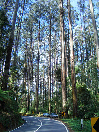
The Great Otway National Park is a national park located in the Barwon South West region of Victoria, Australia. The 103,185-hectare (254,980-acre) national park is situated approximately 162 kilometres (101 mi) southwest of Melbourne, in the Otway Ranges, a low coastal mountain range. It contains a diverse range of landscapes and vegetation types.

Brockman National Park is a national park in the South West region of Western Australia, 288 kilometres (179 mi) south of Perth and 10 km (6.2 mi) south of Pemberton.
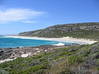
Leeuwin-Naturaliste National Park is a national park in the South West region of Western Australia, 267 km (166 mi) south of Perth. It is named after the two locations at either end of the park which have lighthouses, Cape Leeuwin and Cape Naturaliste. It is located in the Augusta-Margaret River and Busselton council areas, and is claimed to have the highest visiting numbers of any national park in Western Australia. The park received 2.33 million visitors through 2008–2009.
Eucalyptus regnans, known variously as mountain ash, swamp gum, or stringy gum, is a species of medium-sized to very tall forest tree that is native to the Australia states of Tasmania and Victoria. It is a straight-trunked tree with smooth grey bark, but with a stocking of rough brown bark at the base, glossy green, lance-shaped to curved adult leaves, flower buds in groups of between nine and fifteen, white flowers, and cup-shaped or conical fruit. It is the tallest of all flowering plants; the tallest measured living specimen, named Centurion, stands 100 metres tall in Tasmania.

Sclerophyll is a type of vegetation that is adapted to long periods of dryness and heat. The plants feature hard leaves, short internodes and leaf orientation which is parallel or oblique to direct sunlight. The word comes from the Greek sklēros (hard) and phyllon (leaf). The term was coined by A.F.W. Schimper in 1898, originally as a synonym of xeromorph, but the two words were later differentiated.
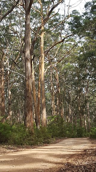
Eucalyptus diversicolor, commonly known as karri, is a species of flowering plant in the family Myrtaceae and is endemic to the south-west of Western Australia. It is a tall tree with smooth light grey to cream-coloured, often mottled bark, lance-shaped adult leaves and barrel-shaped fruit. Found in higher rainfall areas, karri is commercially important for its timber.

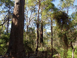
Eucalyptus jacksonii, commonly known as the red tingle, is a species of tall tree endemic to the southwest of Western Australia and is one of the tallest trees found in the state. It has thick, rough, stringy reddish bark from the base of the trunk to the thinnest branches, egg-shaped to lance-shaped adult leaves, flower buds in groups of seven, white flowers and shortened spherical to barrel-shaped fruit.

Eucalyptus patens, commonly known as yarri or blackbutt, is a species of flowering plant in the family Myrtaceae and is endemic to the south-west of Western Australia. It has rough bark on the trunk and branches, lance-shaped leaves, creamy-white flowers and spherical to oval fruit.
Karridale is a small township in the south-west of Western Australia. It is located just north of Augusta and south of Margaret River between Caves Road and Bussell Highway. A newer township was built a short distance north east of the original Old Karridale following fires that destroyed the town in 1961. At the 2006 census, Karridale had a population of 285.

Warren, also known as Karri Forest Region and the Jarrah-Karri forest and shrublands ecoregion, is a biogeographic region in southern Western Australia. Located in the southwest corner of Western Australia between Cape Naturaliste and Albany, it is bordered to the north and east by the Jarrah Forest region. Its defining characteristic is an extensive tall forest of Eucalyptus diversicolor (karri). This occurs on dissected, hilly ground, with a moderately wet climate. Karri is a valuable timber and much of the karri forest has been logged over, but less than a third has been cleared for agriculture. Recognised as a region under the Interim Biogeographic Regionalisation for Australia (IBRA), and as a terrestrial ecoregion by the World Wide Fund for Nature, it was first defined by Ludwig Diels in 1906.
The Campaign to Save Native Forests (W.A.) (CSNF) was the name of a grassroots organisation which grew from a campaign started in Perth, Western Australia, in 1975, as a response to the development of a woodchipping industry in the south-west jarrah and karri forests of Western Australia. The Manjimup woodchip project aroused significant levels of protest in Perth and the South West region out of public concern that inadequate measures had been made for conservation alongside exploitation of the south west hardwood forests.
Jarrah Forest, also known as the Southwest Australia woodlands, is an interim Australian bioregion and ecoregion located in the south west of Western Australia. The name of the bioregion refers to the region's dominant plant community, jarrah forest – a tall, open forest in which the dominant overstory tree is jarrah.
The Forest Products Commission (FPC) is a Western Australian Government trading enterprise established under an Act of Parliament, responsible for the development and marketing of the state's renewable timber resources. The agency was established as part of the then-Court Government's response to the debate regarding logging in old-growth forests. The minister responsible for the agency is the Minister for Forestry, currently Jackie Jarvis of the Labor Party.
Bertmainius tingle, also called the tingle trapdoor spider, is a small basal spider endemic to the tingle and karri forest of southwestern Western Australia. This migid family species of Bertmainius was first recorded in the 1990s.
The Warby-Ovens National Park is a national park located on the lands of the Bangerang clan of the Yorta Yorta Nation in the Hume region of Victoria, Australia near Killawara. The 14,655-hectare (36,210-acre) national park is situated approximately 10 kilometres (6.2 mi) west of Wangaratta and 240 kilometres (150 mi) northeast of Melbourne.

The Cumberland Plain Woodland, also known as Cumberland Plain Bushland and Western Sydney woodland, is a grassy woodland community found predominantly in Western Sydney, New South Wales, Australia, that comprises an open tree canopy, a groundcover with grasses and herbs, usually with layers of shrubs and/or small trees.

