King's Highway Historic District (New Jersey)

Last updated

King's Highway Historic District
Kingston Bridge, Kingston, NJ - south view.jpg
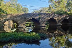
The Kingston Bridge built 1798 to replace one destroyed by George Washington's troops to prevent British pursuit after the Battle of Princeton
Location map of Mercer County, New Jersey.svg
Red pog.svg
The route of the King's Highway Historic District
USA New Jersey location map.svg
Red pog.svg
King's Highway Historic District (New Jersey) (New Jersey)
Usa edcp location map.svg
Red pog.svg
King's Highway Historic District (New Jersey) (the United States)
Location U.S. Route 206 from mile marker 48.30 to 53.90 and New Jersey Route 27 from mile marker 0.0 to 4.10
Coordinates 40°20′53.8″N74°39′52.0″W / 40.348278°N 74.664444°W / 40.348278; -74.664444
Area81 acres (33 ha)
Built1660–1950
ArchitectMultiple
NRHP reference No. 00001493
NJRHP No.353 [1]
Significant dates
Added to NRHPDecember 21, 2000
Designated NJRHPOctober 23, 2000

The King's Highway Historic District covers the portions of U.S. Route 206 and New Jersey Route 27 in New Jersey that connect Lawrenceville (in Lawrence Township) with Kingston (in Franklin Township / South Brunswick, New Jersey) through Princeton. This historic roadway dates to colonial times and was a portion of the King's Highway that was laid out by order of Charles II of England to connect Boston with Charleston. It is lined with many institutions and sites that have played an important role in the History of the United States, including Princeton University and the Princeton Theological Seminary.

Contents

Along the road can be found five National Historic Landmarks: the Lawrenceville School, Morven, Maclean House, Nassau Hall, and the Joseph Henry House. The highway also runs through eight historic districts, from west to east, Lawrence Township Historic District, Princeton Battlefield / Stony Brook Village Historic District, Princeton Historic District, Jugtown Historic District, Kingston Mill Historic District, Lake Carnegie Historic District, Delaware and Raritan Canal Historic District and the Kingston Village Historic District. The governor's mansion of New Jersey, Drumthwacket, independently listed on the National Register of Historic Places, is found on the road in the western part of Princeton. The district was added to the National Register of Historic Places on December 21, 2000 for its significance in commerce, exploration, settlement, military, politics, government and transportation from 1660 to 1950. The highway itself is the only contributing structure. [2]

See also

Related Research Articles

<span class="mw-page-title-main">New Jersey Route 27</span> Highway in New Jersey

Route 27 is a state highway in New Jersey, United States. It runs 38.53 mi (62.01 km) from U.S. Route 206 (US 206) in Princeton, Mercer County northeast to an interchange with Route 21 and Broad Street in Newark, Essex County. The route passes through many communities along the way, including New Brunswick, Highland Park, Edison, Metuchen, Rahway, and Elizabeth. Route 27 is a two- to four-lane undivided highway for most of its length, passing through a variety of urban and suburban environments. It intersects many roads along the way, including Route 18 in New Brunswick, Interstate 287 (I-287) in Edison, the Garden State Parkway in Woodbridge Township, Route 35 in Rahway, Route 28 in Elizabeth, and U.S. Route 22 in Newark. Route 27 crosses the Raritan River on the Albany Street Bridge, which connects Highland Park on the east with New Brunswick on the west.

<span class="mw-page-title-main">Princeton, New Jersey</span> Borough in New Jersey, United States

Princeton is a municipality with a borough form of government in Mercer County, in the U.S. state of New Jersey. It was established on January 1, 2013, through the consolidation of the Borough of Princeton and Princeton Township, both of which are now defunct. As of the 2020 United States census, the borough's population was 30,681, an increase of 2,109 (+7.4%) from the 2010 census combined count of 28,572. In the 2000 census, the two communities had a total population of 30,230, with 14,203 residents in the borough and 16,027 in the township.

<span class="mw-page-title-main">Lawrenceville, New Jersey</span> Place in Mercer County, New Jersey, United States

Lawrenceville is an unincorporated community and census-designated place (CDP) and a major commercial hub within Lawrence Township in Mercer County, in the U.S. state of New Jersey. The community is situated roughly halfway between Princeton and Trenton, although Lawrenceville constitutes part of the New York metropolitan area, the CDP actually is located approximately 15 miles closer to Philadelphia than to New York City; and as with the remainder of Mercer County, lies within the Federal Communications Commission's Philadelphia Designated Market Area. As of the 2020 United States census, the CDP's population was 3,751, a decrease of 136 (−3.5%) from the 3,887 recorded at the 2010 census, which in turn had reflected a decrease of 194 (−4.8%) from the 4,081 counted in the 2000 census.

<span class="mw-page-title-main">Mercer County, New Jersey</span> County in New Jersey, United States

Mercer County is a county located in the U.S. state of New Jersey. Its county seat is Trenton, also the state capital, prompting its nickname The Capital County. Mercer County alone constitutes the Trenton–Princeton metropolitan statistical area and is considered part of the New York combined statistical area by the U.S. Census Bureau, but also directly borders the Philadelphia metropolitan area and is included within the Federal Communications Commission's Philadelphia Designated Media Market Area.

<span class="mw-page-title-main">Lawrence Township, Mercer County, New Jersey</span> Township in Mercer County, New Jersey, United States

Lawrence Township is a township in Mercer County, in the U.S. state of New Jersey. Located at the cross-roads between the Delaware Valley region to the south and the Raritan Valley region to the north, the township is an outer-ring suburb of New York City in the New York Metropolitan area, as defined by the United States Census Bureau, while also directly bordering the Philadelphia metropolitan area and is part of the Federal Communications Commission's Philadelphia Designated Market Area. The township is a regional commercial hub for central New Jersey. As of the 2020 United States census, the township's population was 33,077, a decrease of 395 (−1.2%) from the 2010 census count of 33,472, which in turn reflected an increase of 4,313 (+14.8%) from the 29,159 counted in the 2000 census.

<span class="mw-page-title-main">Princeton Township, New Jersey</span> Populated place in Mercer County, New Jersey, US

Princeton Township was a township in Mercer County, New Jersey, United States, that existed from 1838 until it was dissolved after it was merged with Princeton Borough in 2013 to form Princeton, New Jersey. As of the 2010 United States Census, the township's population was 16,265, reflecting an increase of 238 (+1.5%) from the 16,027 counted in the 2000 Census, which had in turn increased by 2,829 (+21.4%) from the 13,198 counted in the 1990 Census.

<span class="mw-page-title-main">West Windsor, New Jersey</span> Township in Mercer County, New Jersey, US

West Windsor is a township in Mercer County, in the U.S. state of New Jersey. Located within the Raritan Valley region, the township is an outer-ring suburb of New York City in the New York metropolitan area, as defined by the United States Census Bureau. As of the 2020 United States census, the township's population was 29,518, its highest decennial count ever and an increase of 2,353 (+8.7%) from the 27,165 recorded at the 2010 census, which in turn reflected an increase of 5,258 (+24.0%) from the 21,907 counted in the 2000 census.

<span class="mw-page-title-main">Kingston, New Jersey</span> Populated place in Middlesex and Somerset counties, New Jersey, US

Kingston is an unincorporated community and census designated place (CDP) along the border of South Brunswick Township in Middlesex County and Franklin Township in Somerset County, and also located relatively near Princeton in Mercer County in the U.S. state of New Jersey. The historic settlement is in the Raritan Valley region, located along the course of the Millstone River. As of the 2010 United States Census, the CDP's population was 1,493, of which 1,222 were in South Brunswick Township and 271 in Franklin Township.

<span class="mw-page-title-main">U.S. Route 206</span> Highway in New Jersey and Pennsylvania

U.S. Route 206 is a 130.23-mile-long (209.58 km) north–south United States highway in New Jersey and Pennsylvania, United States. Only about a half a mile of its length is in Pennsylvania; the Milford–Montague Toll Bridge carries it over the Delaware River into New Jersey, where it connects to the remainder of the route. Its southern terminus is at an intersection with US 30 and Route 54 in Hammonton. The highway's northern terminus is at an intersection with US 209 near Milford, Pennsylvania; some sources and signs show an overlap with US 209 to end at its parent route US 6. For much of its length, US 206 is a rural two-lane undivided road that passes through the Pine Barrens, agricultural areas, and the Appalachian Mountains of northwestern New Jersey, with some urban and suburban areas. The route connects several cities and towns, including Bordentown, Trenton, Princeton, Somerville, Roxbury, Netcong, and Newton. The road is known as the Disabled American Veterans Highway for much of its length.

<span class="mw-page-title-main">Drumthwacket</span> Historic house in New Jersey

Drumthwacket is the official residence of the governor of the U.S. state of New Jersey at 354 Stockton Street in Princeton, New Jersey, near the state capital of Trenton.

<span class="mw-page-title-main">Clarksburg, New Jersey</span> Populated place in Monmouth County, New Jersey, US

Clarksburg is an unincorporated community located within Millstone Township in Monmouth County, in the U.S. state of New Jersey. The area is served as United States Postal Service ZIP code 08510.

<span class="mw-page-title-main">Millstone River</span> Tributary of the Raritan River in New Jersey, United States

The Millstone River is a 38.6-mile-long (62.1 km) tributary of the Raritan River in central New Jersey in the United States.

<span class="mw-page-title-main">Morven (Princeton, New Jersey)</span> United States historic place

Morven, known officially as Morven Museum & Garden, is a historic 18th-century house at 55 Stockton Street in Princeton, Mercer County, New Jersey, United States. It served as the governor's mansion for nearly four decades in the twentieth century, and has been designated a National Historic Landmark for its association with Richard Stockton (1730-1781), a signer of the United States Declaration of Independence.

<span class="mw-page-title-main">County Route 533 (New Jersey)</span>

County Route 533 is a county highway in the U.S. state of New Jersey. The highway extends 32.78 miles (52.75 km) from the White Horse Circle, in Hamilton Township to Middlesex CR 607 on the border of Bound Brook and Middlesex Borough. CR 533 shares a long concurrency with U.S. Route 206 through Princeton and Montgomery Township, while portions of the roadway in Somerset County are part of the Millstone River Valley Scenic Byway.

<span class="mw-page-title-main">Lawrence Township Historic District</span> Historic house in New Jersey, United States

The Lawrence Township Historic District is a 550-acre (220 ha) historic district encompassing the community of Lawrenceville in Lawrence Township, Mercer County, New Jersey, United States. It was added to the National Register of Historic Places on September 14, 1972 for its significance in architecture, landscape architecture, literature, military history, and transportation. The district includes 45 contributing buildings.

The Assunpink Trail was a Native American trail in what later became Middlesex, Somerset, and Mercer counties in the central and western part of New Jersey. Like Assunpink Creek, the trail takes its name from the Algonquian language Ahsën'pink, meaning "stony, watery place".

<span class="mw-page-title-main">Princeton Historic District (Princeton, New Jersey)</span> Historic district in New Jersey, United States

The Princeton Historic District is a 370-acre (150 ha) historic district located in Princeton, New Jersey that was listed on the U.S. National Register of Historic Places in 1975. It stretches from Marquand Park in the west to the Eating Clubs in the East, from the Princeton Cemetery in the north to the Graduate College in the south. The district encompasses the core parts of the campuses of the Princeton Theological Seminary and Princeton University. It also includes the business district centered on Nassau Street and many historic homes, both mansions in the western section and more humble dwellings in the Witherspoon/Jackson neighborhood. Notable churches within the district include Nassau Presbyterian Church, Trinity Episcopal, Nassau Christian Center, and the Princeton University Chapel. The district is home to seven of Princeton's nine, and New Jersey's fifty-eight, National Historic Landmarks, the largest concentration of such sites in the state.

<span class="mw-page-title-main">Kingston Mill Historic District</span> Historic district in New Jersey, United States

The Kingston Mill Historic District is a 49-acre (20 ha) historic district in Kingston, New Jersey. It is roughly bounded by the Millstone, River, and Princeton-Kingston Roads in the townships of Princeton in Mercer County, South Brunswick in Middlesex County, and Franklin in Somerset County. It was added to the National Register of Historic Places on April 10, 1986 for its significance in engineering, exploration/settlement, industry, and transportation. The district includes 16 contributing buildings and 2 contributing structures.

<span class="mw-page-title-main">Washington Road Elm Allée</span> United States historic place

The Washington Road Elm Allée is a 0.7-mile-long (1.1 km) stretch of Washington Road in West Windsor, New Jersey that is lined with Princeton Elm trees. The allée runs through the West Windsor fields of Princeton University and provides, along with the bridge over Lake Carnegie, a dramatic entrance to the campus. The Delaware and Raritan Canal can be found at the northern end of the allée, just before the lake. A jogging path runs through the allée and connects to the canal towpath, the main campus of the university, and other trails through the adjacent fields.

<span class="mw-page-title-main">Baker–Brearley House</span> United States historic place

The Brearley House is a historic Georgian house built in 1761 in Lawrenceville, New Jersey. It was added to the National Register of Historic Places in 1979.

References

  1. "New Jersey and National Registers of Historic Places — Mercer County" (PDF). New Jersey Department of Environmental Protection — Historic Preservation Office. April 5, 2013. p. 8. Archived from the original (PDF) on May 16, 2013. Retrieved June 4, 2013.
  2. Greiff, Constance. "National Register of Historic Places Inventory/Nomination: King's Highway Historic District". National Register of Historic Places. National Park Service.With 63 accompanying pictures