Lake City, Michigan

Last updated
Lake City, Michigan
Lake City, Michigan.jpg
Looking north along Main Street (M-66)
Nickname: 
"Michigan's Christmas Tree Capital"
Lake City, MI location.png
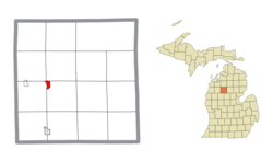
Location within Missaukee County and the state of Michigan
USA Michigan location map.svg
Red pog.svg
Lake City
Usa edcp location map.svg
Red pog.svg
Lake City
Coordinates: 44°19′57″N85°12′47″W / 44.33250°N 85.21306°W / 44.33250; -85.21306
CountryFlag of the United States.svg United States
State Flag of Michigan.svg  Michigan
County Missaukee
Settled1868
Incorporated1889 (village)
1932 (city)
Government
  Type Mayor–council
   Mayor Craig Ardis
Area
[1]
  Total1.05 sq mi (2.71 km2)
  Land1.05 sq mi (2.71 km2)
  Water0.00 sq mi (0.00 km2)
Elevation
1,250 ft (381 m)
Population
 (2020) [2]
  Total829
  Density791.79/sq mi (305.68/km2)
Time zone UTC-5 (Eastern (EST))
  Summer (DST) UTC-4 (EDT)
ZIP Code
49651
Area code 231
FIPS code 26-44480 [3]
GNIS feature ID0629968, [4] 1626581 [5]
Website cityoflakecity.com

Lake City is a city in the U.S. state of Michigan. It is the county seat of Missaukee County, and is the largest city within the county. The city is located in the Northern Lower Peninsula of Michigan. As of the 2020 census, the population of Lake City was 829. [2] Lake City has been nicknamed "Michigan's Christmas Tree Capital", due to the high number of farms near the city. [6] [7] [8]

Contents

History

Lake City, 1890s Lake City, Michigan (1890's).jpg
Lake City, 1890s

The community's first settler, Daniel Reeder, built his cabin on Muskrat Lake, now Lake Missaukee, in 1868. On January 22, 1872, Reeder was the name of post office open and the last name of its first postmaster, Daniel. The county selected Reeder by a one-vote margin as the county seat in 1873. The community became a station of the Grand Rapids and Indiana Railroad. The community was renamed on January 25, 1877, to Lake City. Lake City was incorporated as a village and platted in 1889. [9] The village became a city in 1932. [6]

Much of Missaukee County grew in the early 20th century because of the region's timber industry. The community continues to thrive because of local lumber mills. [8]

Geography

Lake City is in western Missaukee County, 14 miles (23 km) by road northeast of Cadillac and 13 miles (21 km) southeast of Manton. According to the United States Census Bureau, the city has a total area of 1.05 square miles (2.72 km2), all land. [1]

Lake City derives its name from the numerous lakes within the vicinity, including Lake Missaukee, which forms the western boundary of the city. Other large lakes nearby include Crooked Lake and Sapphire Lake. [6]

Climate

Climate data for Lake City, Michigan (1991–2020 normals, extremes 1896–present)
MonthJanFebMarAprMayJunJulAugSepOctNovDecYear
Record high °F (°C)61
(16)
60
(16)
86
(30)
87
(31)
93
(34)
103
(39)
106
(41)
100
(38)
97
(36)
86
(30)
76
(24)
64
(18)
106
(41)
Mean daily maximum °F (°C)27.3
(−2.6)
30.3
(−0.9)
40.5
(4.7)
53.2
(11.8)
66.3
(19.1)
76.2
(24.6)
80.4
(26.9)
78.6
(25.9)
71.1
(21.7)
57.3
(14.1)
43.4
(6.3)
32.6
(0.3)
54.8
(12.7)
Daily mean °F (°C)18.6
(−7.4)
19.9
(−6.7)
28.9
(−1.7)
41.3
(5.2)
53.6
(12.0)
63.4
(17.4)
67.5
(19.7)
65.7
(18.7)
57.9
(14.4)
46.1
(7.8)
34.8
(1.6)
25.0
(−3.9)
43.6
(6.4)
Mean daily minimum °F (°C)9.9
(−12.3)
9.6
(−12.4)
17.3
(−8.2)
29.4
(−1.4)
40.9
(4.9)
50.7
(10.4)
54.5
(12.5)
52.8
(11.6)
44.7
(7.1)
35.0
(1.7)
26.2
(−3.2)
17.5
(−8.1)
32.4
(0.2)
Record low °F (°C)−37
(−38)
−41
(−41)
−37
(−38)
−11
(−24)
17
(−8)
24
(−4)
32
(0)
27
(−3)
20
(−7)
11
(−12)
−13
(−25)
−25
(−32)
−41
(−41)
Average precipitation inches (mm)1.88
(48)
1.45
(37)
1.88
(48)
3.53
(90)
3.47
(88)
3.48
(88)
3.11
(79)
3.42
(87)
3.04
(77)
3.67
(93)
2.52
(64)
1.94
(49)
33.39
(848)
Average snowfall inches (cm)18.7
(47)
13.9
(35)
9.4
(24)
5.2
(13)
0.3
(0.76)
0.0
(0.0)
0.0
(0.0)
0.0
(0.0)
0.0
(0.0)
1.4
(3.6)
9.0
(23)
16.1
(41)
74.0
(188)
Average precipitation days (≥ 0.01 in)16.212.211.112.513.011.611.111.212.114.913.615.1154.6
Average snowy days (≥ 0.1 in)14.811.57.83.80.20.00.00.00.01.06.513.258.8
Source: NOAA [10] [11]

Education

Lake City is served by the Lake City Area Schools district. High school students are served by Lake City High School.

Transportation

Major highways

Demographics

Historical population
CensusPop.Note
1880 61
1890 663986.9%
1900 81623.1%
1910 740−9.3%
1920 582−21.4%
1930 6104.8%
1940 69313.6%
1950 7193.8%
1960 718−0.1%
1970 704−1.9%
1980 84319.7%
1990 8581.8%
2000 9237.6%
2010 836−9.4%
2020 829−0.8%
U.S. Decennial Census [12]

2010 census

As of the census [13] of 2010, there were 836 people, 337 households, and 216 families living in the city. The population density was 796.2 inhabitants per square mile (307.4/km2). There were 489 housing units at an average density of 465.7 per square mile (179.8/km2). The racial makeup of the city was 95.2% White, 1.2% African American, 1.7% Native American, 0.7% Asian, and 1.2% from two or more races. Hispanic or Latino of any race were 2.9% of the population.

There were 337 households, of which 28.8% had children under the age of 18 living with them, 45.4% were married couples living together, 12.2% had a female householder with no husband present, 6.5% had a male householder with no wife present, and 35.9% were non-families. 32.0% of all households were made up of individuals, and 17% had someone living alone who was 65 years of age or older. The average household size was 2.35 and the average family size was 2.89.

The median age in the city was 40.5 years. 23.4% of residents were under the age of 18; 8.6% were between the ages of 18 and 24; 21.2% were from 25 to 44; 27.5% were from 45 to 64; and 19.3% were 65 years of age or older. The gender makeup of the city was 51.2% male and 48.8% female.

2000 census

As of the census [3] of 2000, there were 923 people, 381 households, and 238 families living in the city. The population density was 854.9 inhabitants per square mile (330.1/km2). There were 493 housing units at an average density of 456.6 per square mile (176.3/km2). The racial makeup of the city was 97.72% White, 0.11% African American, 0.43% Native American, 0.76% Asian, 0.43% from other races, and 0.54% from two or more races. Hispanic or Latino of any race were 1.63% of the population.

There were 381 households, out of which 29.1% had children under the age of 18 living with them, 46.7% were married couples living together, 12.9% had a female householder with no husband present, and 37.3% were non-families. 33.1% of all households were made up of individuals, and 15.7% had someone living alone who was 65 years of age or older. The average household size was 2.32 and the average family size was 2.93.

In the city, the population was spread out, with 24.1% under the age of 18, 9.6% from 18 to 24, 22.5% from 25 to 44, 23.6% from 45 to 64, and 20.2% who were 65 years of age or older. The median age was 41 years. For every 100 females, there were 89.9 males. For every 100 females age 18 and over, there were 86.4 males.

The median income for a household in the city was $28,864, and the median income for a family was $34,286. Males had a median income of $27,361 versus $19,044 for females. The per capita income for the city was $17,067. About 10.7% of families and 13.1% of the population were below the poverty line, including 13.7% of those under age 18 and 17.2% of those age 65 or over.

Notable people

Related Research Articles

<span class="mw-page-title-main">Winterfield Township, Michigan</span> Civil township in Michigan, United States

Winterfield Township is a civil township of Clare County in the U.S. state of Michigan. The population was 460 at the 2020 census.

<span class="mw-page-title-main">Fife Lake Township, Michigan</span> Civil township in Michigan, United States

Fife Lake Township is a civil township of Grand Traverse County in the U.S. state of Michigan. As of the 2020 census, the township population was 1,526, a slight increase from 1,517 at the 2000 census. The village of Fife Lake is located within the township.

<span class="mw-page-title-main">Bloomfield Township, Missaukee County, Michigan</span> Civil township in Michigan, United States

Bloomfield Township is a civil township of Missaukee County in the U.S. state of Michigan. As of the 2020 census, the township population was 574.

<span class="mw-page-title-main">Butterfield Township, Michigan</span> Civil township in Michigan, United States

Butterfield Township is a civil township of Missaukee County in the U.S. state of Michigan. As of the 2020 census, the township population was 473.

<span class="mw-page-title-main">Caldwell Township, Michigan</span> Civil township in Michigan, United States

Caldwell Township is a civil township of Missaukee County in Michigan, in the U.S. The population was 1,394 at the 2020 census.

<span class="mw-page-title-main">Clam Union Township, Michigan</span> Civil township in Michigan, United States

Clam Union Township is a civil township of Missaukee County in the U.S. state of Michigan. The population was 907 at the 2020 census.

<span class="mw-page-title-main">Enterprise Township, Michigan</span> Civil township in Michigan, United States

Enterprise Township is a civil township of Missaukee County in Michigan, in the U.S. The population was 174 at the 2020 census.

<span class="mw-page-title-main">Forest Township, Missaukee County, Michigan</span> Civil township in Michigan, United States

Forest Township is a civil township of Missaukee County in the U.S. state of Michigan. The population was 1,184 at the 2020 census.

<span class="mw-page-title-main">Lake Township, Missaukee County, Michigan</span> Civil township in Michigan, United States

Lake Township is a civil township of Missaukee County in the U.S. state of Michigan. The population was 2,827 at the 2020 census, which makes it the county's most-populated municipality.

<span class="mw-page-title-main">McBain, Michigan</span> City in Michigan, United States

McBain is a city in Missaukee County in the U.S. state of Michigan. The population was 637 at the 2020 census, making McBain the eighth-smallest city in the state of Michigan by population.

<span class="mw-page-title-main">Pioneer Township, Michigan</span> Civil township in Michigan, United States

Pioneer Township is a civil township of Missaukee County in the U.S. state of Michigan. The population was 508 at the 2020 census, up from 451 in 2010.

<span class="mw-page-title-main">Reeder Township, Michigan</span> Civil township in Michigan, United States

Reeder Township is a civil township of Missaukee County in the U.S. state of Michigan. As of the 2020 census, the township population was 1,199.

<span class="mw-page-title-main">Riverside Township, Michigan</span> Civil township in Michigan, United States

Riverside Township is a civil township of Missaukee County in the U.S. state of Michigan. The population was 1,124 at the 2020 census.

<span class="mw-page-title-main">Haring Township, Michigan</span> Township in Wexford County, Michigan

Haring Township is a charter township of Wexford County in the U.S. state of Michigan. The population was 3,556 at the 2020 census, making it the most populous township in Wexford County. The township has a boundary with the city of Cadillac, to the south.

<span class="mw-page-title-main">Springfield Township, Kalkaska County, Michigan</span> Civil township in Michigan, United States

Springfield Township is a civil township of Kalkaska County in the U.S. state of Michigan. The population was 1,562 at the 2020 census.

<span class="mw-page-title-main">Aetna Township, Missaukee County, Michigan</span> Civil township in Michigan, United States

Aetna Township is a civil township of Missaukee County in the U.S. state of Michigan. As of the 2020 census, the township population was 429.

<span class="mw-page-title-main">Holland Township, Missaukee County, Michigan</span> Civil township in Michigan, United States

Holland Township is a civil township of Missaukee County in the U.S. state of Michigan. The population was 221 at the 2020 census.

<span class="mw-page-title-main">Norwich Township, Missaukee County, Michigan</span> Civil township in Michigan, United States

Norwich Township is a civil township of Missaukee County in the U.S. state of Michigan. The population was 631 at the 2020 census.

<span class="mw-page-title-main">Richland Township, Missaukee County, Michigan</span> Civil township in Michigan, United States

Richland Township is a civil township of Missaukee County in the U.S. state of Michigan. The population was 1,489 at the 2020 census.

<span class="mw-page-title-main">West Branch Township, Missaukee County, Michigan</span> Civil township in Michigan, United States

West Branch Township is a civil township of Missaukee County in the U.S. state of Michigan. The population was 452 at the 2020 census.

References

  1. 1 2 "2023 U.S. Gazetteer Files: Michigan". United States Census Bureau. Retrieved October 23, 2023.
  2. 1 2 "P1. Race – Lake City city, Michigan: 2020 DEC Redistricting Data (PL 94-171)". U.S. Census Bureau. Retrieved October 23, 2023.
  3. 1 2 "U.S. Census website". United States Census Bureau . Retrieved 2008-01-31.
  4. U.S. Geological Survey Geographic Names Information System: Lake City, Michigan
  5. U.S. Geological Survey Geographic Names Information System: City of Lake City
  6. 1 2 3 "The 18 tiniest cities in Michigan". Flint Journal. Mlive Media Group. December 4, 2016. p. 9. Retrieved December 5, 2016.
  7. "Find a County". National Association of Counties. Retrieved 2011-06-07.
  8. 1 2 "Lake City Area History". Lake City Area Chamber of Commerce. 2015-12-07. Retrieved 2017-08-16.
  9. Romig 1986, pp. 312.
  10. "NowData - NOAA Online Weather Data". National Oceanic and Atmospheric Administration. Retrieved September 2, 2021.
  11. "Station: Lake City EXP Farm, MI". U.S. Climate Normals 2020: U.S. Monthly Climate Normals (1991-2020). National Oceanic and Atmospheric Administration. Retrieved September 2, 2021.
  12. "Census of Population and Housing". Census.gov. Retrieved June 4, 2015.
  13. "U.S. Census website". United States Census Bureau . Retrieved 2012-11-25.

Sources