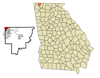
Lakeview is an unincorporated community and census-designated place (CDP) in Catoosa and Walker counties in the U.S. state of Georgia. The population was 4,820 at the 2000 census and 4,777 at the 2020 census. It is part of the Chattanooga, TN–GA Metropolitan Statistical Area.
Lakeview Estates, also known as Sunrise Lakes by local residents, is an unincorporated community and census-designated place (CDP) in Rockdale County, Georgia, United States. The population was 2,660 in 2020.

Killona is a census-designated place (CDP) in St. Charles Parish, Louisiana, United States. The population was 724 in 2020. On December 14, 2022, the town was hit by a destructive and deadly EF2 tornado that damaged or destroyed numerous structures, killed one person, and injured eight others.

Lakeview is a hamlet and census-designated place (CDP) in the Town of Hempstead in Nassau County, on Long Island, in New York, United States. The population was 6,077 at the 2020 census.

Lakeview is a census-designated place (CDP) in Grant County, Washington, United States. The population was 915 at the 2010 census, up from 797 at the 2000 census. The community is referred to as Lakeview Park on topographic maps and by locals.
Eagle Bend is a census-designated place and unincorporated community in Warren County, Mississippi. It is approximately 31 miles northwest of downtown Vicksburg, and is part of the Vicksburg Micropolitan Statistical Area.
St. James is a census-designated place in St. James Parish, Louisiana, United States on the west bank of the Mississippi River. It is part of the New Orleans Metropolitan Area. Its population was 828 as of the 2010 census.
Austin is a census-designated place and unincorporated community in Tunica County, Mississippi, United States. Per the 2020 Census, the population was 51.
Eudora is a census-designated place and unincorporated community located in southwestern DeSoto County, Mississippi, United States, approximately 25 miles (40 km) south of Memphis, Tennessee. The intersection of Mississippi Highway 301 and old Mississippi Highway 304 has been the traditional heart of Eudora for decades.

Rena Lara is a census-designated place and unincorporated community located along Mississippi Highway 1 in southwestern Coahoma County, Mississippi, United States. Rena Lara is located on the former Riverside Division of the Yazoo and Mississippi Valley Railroad. Rena Lara was once home to two general stores, two grocery stores, and the Richardson and May Land & Planting Company.
De Soto is a census-designated place and unincorporated community in Clarke County, Mississippi, United States.
Darling is a census-designated place in Quitman County, Mississippi. Darling is located on Mississippi Highway 3, north of Marks. Per the 2020 Census, the population was 154.
Bobo is a census-designated place and unincorporated community in Coahoma County, Mississippi, United States. Bobo is located on U.S. routes 61 and 278, southwest of Clarksdale.
Van Vleet is a census-designated place and unincorporated community in Chickasaw County, Mississippi, United States. Van Vleet is located at the junction of Mississippi Highway 32 and Mississippi Highway 385, 8 miles (13 km) northeast of Houston. Van Vleet has a post office with ZIP code 38877.

Dundee is a census-designated place and unincorporated community in Tunica County, Mississippi, United States. Dundee is 12 miles (19 km) south-southwest of Tunica. Dundee has a post office with ZIP code 38626.
Pleasant Hill is a census-designated place and unincorporated community located in DeSoto County, Mississippi, United States, located approximately 9 miles (14 km) southwest of Hernando and 8 miles (13 km) southeast of Eudora, just east of Arkabutla Lake.
Red Banks is a census-designated place and unincorporated community in Marshall County, Mississippi, United States. It was first listed as a CDP in the 2020 census, which reported a population of 215.
Victoria is a census-designated place and unincorporated community in Marshall County, Mississippi, United States. It was first listed as a CDP in the 2020 census, which recorded a population of 1,066.
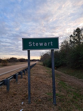
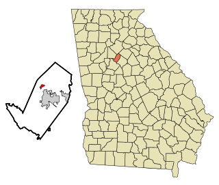
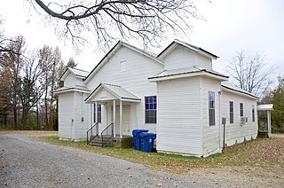
Stewart is a census-designated place and unincorporated community in Montgomery County, Mississippi, United States. As of the 2020 census, it had a population of 99.

Bolivar is a census-designated place and unincorporated community in Bolivar County, Mississippi, United States.


