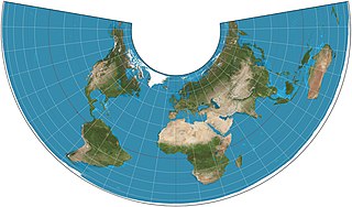
In cartography, a map projection is any of a broad set of transformations employed to represent the curved two-dimensional surface of a globe on a plane. In a map projection, coordinates, often expressed as latitude and longitude, of locations from the surface of the globe are transformed to coordinates on a plane. Projection is a necessary step in creating a two-dimensional map and is one of the essential elements of cartography.

Johann Heinrich Lambert was a polymath from the Republic of Mulhouse, generally identified as either Swiss or French, who made important contributions to the subjects of mathematics, physics, philosophy, astronomy and map projections.

The azimuthal equidistant projection is an azimuthal map projection. It has the useful properties that all points on the map are at proportionally correct distances from the center point, and that all points on the map are at the correct azimuth (direction) from the center point. A useful application for this type of projection is a polar projection which shows all meridians as straight, with distances from the pole represented correctly.

A Lambert conformal conic projection (LCC) is a conic map projection used for aeronautical charts, portions of the State Plane Coordinate System, and many national and regional mapping systems. It is one of seven projections introduced by Johann Heinrich Lambert in his 1772 publication Anmerkungen und Zusätze zur Entwerfung der Land- und Himmelscharten.

The Albers equal-area conic projection, or Albers projection, is a conic, equal area map projection that uses two standard parallels. Although scale and shape are not preserved, distortion is minimal between the standard parallels.

The Lambert azimuthal equal-area projection is a particular mapping from a sphere to a disk. It accurately represents area in all regions of the sphere, but it does not accurately represent angles. It is named for the Swiss mathematician Johann Heinrich Lambert, who announced it in 1772. "Zenithal" being synonymous with "azimuthal", the projection is also known as the Lambert zenithal equal-area projection.

In cartography, the Lambert cylindrical equal-area projection, or Lambert cylindrical projection, is a cylindrical equal-area projection. This projection is undistorted along the equator, which is its standard parallel, but distortion increases rapidly towards the poles. Like any cylindrical projection, it stretches parallels increasingly away from the equator. The poles accrue infinite distortion, becoming lines instead of points.

The Aitoff projection is a modified azimuthal map projection proposed by David A. Aitoff in 1889. Based on the equatorial form of the azimuthal equidistant projection, Aitoff first halves longitudes, then projects according to the azimuthal equidistant, and then stretches the result horizontally into a 2:1 ellipse to compensate for having halved the longitudes.

The Hammer projection is an equal-area map projection described by Ernst Hammer in 1892. Using the same 2:1 elliptical outer shape as the Mollweide projection, Hammer intended to reduce distortion in the regions of the outer meridians, where it is extreme in the Mollweide.

The Schmidt net is a manual drafting method for the Lambert azimuthal equal-area projection using graph paper. It results in one lateral hemisphere of the Earth with the grid of parallels and meridians. The method is common in geoscience.
In cartography, a conformal map projection is one in which every angle between two curves that cross each other on Earth is preserved in the image of the projection; that is, the projection is a conformal map in the mathematical sense. For example, if two roads cross each other at a 39° angle, their images on a map with a conformal projection cross at a 39° angle.
There are several projections used in maps carrying the name of Johann Heinrich Lambert:
The European grid is a proposed, multipurpose Pan-European mapping standard. It is based on the ETRS89 coordinate reference system and the Lambert Azimuthal Equal-Area projection, with the centre of the projection at the point 52° N, 10° E and false easting: x0 = 4321000 m, false northing: y0 = 3210000 m .

The Wiechel projection is an pseudoazimuthal, equal-area map projection, and a novelty map presented by William H. Wiechel in 1879. When centered on the pole, it has semicircular meridians arranged in a pinwheel. Distortion of direction, shape, and distance is considerable in the edges.
In geodesy, a map projection of the triaxial ellipsoid maps Earth or some other astronomical body modeled as a triaxial ellipsoid to the plane. Such a model is called the reference ellipsoid. In most cases, reference ellipsoids are spheroids, and sometimes spheres. Massive objects have sufficient gravity to overcome their own rigidity and usually have an oblate ellipsoid shape. However, minor moons or small solar system bodies are not under hydrostatic equilibrium. Usually such bodies have irregular shapes. Furthermore, some of gravitationally rounded objects may have a tri-axial ellipsoid shape due to rapid rotation or unidirectional strong tidal forces.
The Eckert-Greifendorff projection is an equal-area map projection described by Max Eckert-Greifendorff in 1935. Unlike his previous six projections, it is not pseudocylindrical.

Snyder equal-area projection is a polyhedral map projection used in the ISEA discrete global grids. It is named for John P. Snyder, who developed the projection in the 1990s.

In cartography, an equivalent, authalic, or equal-area projection is a map projection that preserves relative area measure between any and all map regions. Equivalent projections are widely used for thematic maps showing scenario distribution such as population, farmland distribution, forested areas, and so forth, because an equal-area map does not change apparent density of the phenomenon being mapped.


