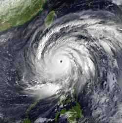
The Philippines is archipelagic country in Southeast Asia, located in the northwest Pacific Ocean. It consists of 7,641 islands. The country is known to be "the most exposed country in the world to tropical storms", with about twenty tropical cyclones entering the Philippine area of responsibility each year. In the Philippine languages, tropical cyclones are generally called bagyo. [1]
Climatologically, in the Northwest Pacific basin, most tropical cyclones develop between May and October. However, the Philippines can experience a tropical cyclone anytime in the year, with the most storms during the months of June to September. This article includes any tropical cyclone of any intensity that affected the Philippines between 1963 and 1999.
This section is empty. You can help by adding to it. (January 2022) |
1970:
October 13–14, 1970: Typhoon Joan (Sening) lashes Luzon and particularly Visayas, killing 770 total.
October 19–21, 1970: Typhoon Kate (Titang) was one of the tropical cyclones closest to form on the equator, makes landfall to Mindanao killing 631 people in total.
November 19–21, 1970: Typhoon Patsy (Yoling) made landfall in Luzon and killed 264 people.
August 26–29, 1984: Tropical Storm June (Maring) made landfall in Luzon just days before Typhoon Ike (Nitang) made a more deadly and devastating landfalls.
September 1–4, 1984: Typhoon Ike (Nitang) devastated Visayas, Mindanao and some parts of Southern Luzon, Deaths from the typhoon is 1,474.
October 28–31, 1984: Severe Tropical Storm Warren (Reming) though didn’t make any landfalls, its outflow caused intense rainfall over parts of Visayas, Palawan and Luzon. Killing 69 people.
November 5–7, 1984: Typhoon Agnes (Undang) made several landfalls across Visayas region, killing 895 people.
Month | Number of Storms |
---|---|
January | |
February | |
March | |
April | |
May | |
June | |
July | |
August | |
September | |
October | |
November | |
December |
The following list are the deadliest storms that impacted the Philippines between 1963 and 1999. This list only includes typhoons that had death tolls exceeding 300. Only two storms exceeded death numbers above 1,000: Thelma (Uring) and Ike (Nitang). The total number of deaths recorded are only from the country itself.
Rank | Name | Year | Number of Deaths |
---|---|---|---|
1 | Thelma (Uring) | 1991 | 5,081 |
2 | Ike (Nitang) | 1984 | 1,426 |
3 | Nina (Sisang) | 1987 | 979 |
4 | Angela (Rosing) | 1995 | 936 |
5 | Agnes (Undang) | 1984 | 895 |
6 | Joan (Sening) | 1970 | 768 |
7 | Mike (Ruping) | 1990 | 748 |
8 | Kate (Titang) | 1970 | 631 |
9 | Irma (Anding) | 1981 | 585 |
10 | Louise (Ining) | 1964 | ≥577 |
11 | Flo (Kadiang) | 1993 | 576 |
12 | Olga (Didang) | 1976 | 374 |
13 | Babs (Loleng) | 1998 | 303 |
14T | Emma (Welming) | 1967 | 300 |
14T | Rita (Kading) | 1978 | ≥300 |
Typhoon Imbudo, known in the Philippines as Super Typhoon Harurot, was a powerful typhoon that struck the Philippines and southern China in July 2003. The seventh named storm and fourth typhoon of the season, Imbudo formed on July 15 to the east of the Philippines. The storm moved generally west-northward for much of its duration due to a ridge to the north. Favorable conditions allowed Imbudo to intensify, gradually at first before undergoing rapid deepening on July 19. After reaching typhoon status, Imbudo strengthened further to peak 10–minute sustained winds of 165 km/h (103 mph) on July 20. The typhoon made landfall on northern Luzon near peak intensity on July 22, but quickly weakened over land. Once in the South China Sea, Imbudo re-intensified slightly before making its final landfall in southern China near Yangjiang on July 24, dissipating the next day.
Typhoon Babs, known in the Philippines as Typhoon Loleng, was a powerful typhoon that struck the Philippines days after Typhoon Zeb hit the same area. The seventh typhoon of the inactive 1998 Pacific typhoon season, Babs formed on October 14 between the Philippines and Guam. The storm moved westward initially, failing to intensify initially due to the outflow from Typhoon Zeb to the northwest. Babs slowed and briefly turned to the south before advancing to the northwest, whereupon it rapidly intensified into a strong typhoon. On October 20, the official Japan Meteorological Agency (JMA) estimated peak 10‑minute winds of 155 km/h (96 mph), while the unofficial Joint Typhoon Warning Center (JTWC) estimated peak 1‑minute winds of 250 km/h (160 mph), making Babs an unofficial super typhoon. The storm struck the Philippine island of Catanduanes at that intensity and weakened slightly before hitting Luzon. Babs turned northward once in the South China Sea, later weakening due to unfavorable conditions and transitioning into an extratropical cyclone on October 27 in the Taiwan Strait.
Typhoon Parma, known in the Philippines as Super Typhoon Pepeng, was the second-wettest typhoon to affect the Philippines, and the second typhoon to affect the country within the span of a week during September 2009.
The effects of the 2009 Pacific typhoon season in the Philippines were considered some of the worst in decades. Throughout the year, series of typhoons impacted the country, with the worst damage occurring during September and October from Typhoons Ketsana (Ondoy) and Parma (Pepeng).
Severe Tropical Storm Linfa, known in the Philippines as Tropical Storm Chedeng, brought deadly flooding to areas of the Philippines and Japan in May and June 2003. The fourth named storm within the northwestern Pacific that year, Linfa developed as a tropical depression just off the western coast of Luzon on May 25. The disturbance quickly intensified to reach tropical storm intensity a few hours after cyclogenesis. However, intensification leveled off as Linfa executed a small clockwise loop before a subsequent landfall on Luzon on May 27. Due to land interaction the storm temporarily weakened and decoupled before reforming in the Philippine Sea. Afterwards Linfa began reintensifying and reached its peak intensity on May 29 with maximum sustained winds of 100 km/h (65 mph) and a barometric pressure of 980 mbar. Following its peak the tropical storm began to deteriorate and transitioned into an extratropical cyclone on May 30; these extratropical remnants continued to track northward through Japan before dissipating in the Sea of Okhotsk on June 4.
Severe Tropical Storm Rumbia, known in the Philippines as Tropical Storm Gorio, was a tropical cyclone that brought widespread flooding in areas of the Philippines and China late June and early July 2013. The sixth internationally named storm of the season, Rumbia formed from a broad area of low pressure situated in the southern Philippine Sea on June 27. Steadily organizing, the initial tropical depression moved towards the northwest as the result of a nearby subtropical ridge. On June 28, the disturbance strengthened to tropical storm strength, and subsequently made its first landfall on Eastern Samar in the Philippines early the following day. Rumbia spent roughly a day moving across the archipelago before emerging into the South China Sea. Over open waters, Rumbia resumed strengthening, and reached its peak intensity with winds of 95 km/h (50 mph) on July 1, ranking it as a severe tropical storm. The tropical cyclone weakened slightly before moving ashore the Leizhou Peninsula late that day. Due to land interaction, Rumbia quickly weakened into a low pressure area on July 2 and eventually dissipated soon afterwards.
Typhoon Nanmadol, known in the Philippines as Super Typhoon Yoyong, was the last of four consecutive tropical cyclones to strike the Philippines in 2004. A quickly moving system, Nanmadol brought heavy rainfall and strong winds over the same regions impacted by the previous storms, exacerbating flood conditions in Luzon and surrounding regions. Together Nanmadol and these systems accounted for around 1,000 deaths in the Philippines. The typhoon later became the first December tropical cyclone to strike Taiwan since record keeping began, bringing along with it heavy rain, which also affected nearby regions of eastern China. As an extratropical storm, Nanmadol brought gusty winds and rain to Japan.
Tropical Storm Fung-wong, known in the Philippines as Tropical Storm Mario, was a relatively weak tropical cyclone which affected the northern Philippines, Taiwan and the Eastern China. The sixteenth named storm of the 2014 typhoon season, Fung-wong caused severe flooding in Luzon, especially Metro Manila.
The effects of the 2013 Pacific typhoon season in the Philippines were considered some of the worst in decades. Throughout the year, a series of typhoons impacted the country, with the worst impacts coming from Typhoon Haiyan, especially in death toll, during November.
The 2017 Visayas and Mindanao floods was an event that caused extreme flooding within parts of the Philippines, caused by several low-pressure systems. In mid-January 2017, several parts of Visayas and Mindanao experienced flooding as a result of a low-pressure area, combined with the tail-end of a cold front.
Tropical Storm Haikui, known in the Philippines as Tropical Storm Salome, was a weak tropical cyclone that affected the Philippine archipelagos of Luzon and Visayas. Forming as the twenty-fourth named storm of the 2017 typhoon season, Haikui developed as a tropical depression to the east of Samar on November 9. Traversing some Philippine islands, the system gradually intensified into a named tropical storm by November 10. In that same day, Haikui emerged to the South China Sea. By November 12, the Japan Meteorological History downgraded the storm into a tropical depression. The storm dissipated on November 13, while meteorologists from the USA recorded the storm until November 14.
Typhoon Kammuri, known in the Philippines as Typhoon Tisoy, was a powerful typhoon which impacted the Philippines in early December 2019. Kammuri, which means crown or Corona Borealis in Japanese, the twenty-eighth named storm and sixteenth typhoon of the 2019 Pacific typhoon season, Kammuri developed from a tropical wave situated a couple hundred kilometers south of the Mariana Islands. From November 25 to 27, the system tracked westward at a steady pace and rate of intensification, first making minor impacts in Guam. On November 28, the system intensified into a typhoon as environmental conditions became marginally conducive for significant development. From November 29 to December 1, Kammuri was unable to strengthen to previous estimates due to its near stationary movement as a result of weak steering currents, upwelling itself consequently. On December 2, the system tracked westward at a much faster speed of 19 km/h (12 mph) and rapidly intensified over warm Philippine Sea waters, before making landfall in the Bicol Region of the Philippines at peak intensity as a category 4-equivalent typhoon.
Typhoon Vongfong, known in the Philippines as Typhoon Ambo, was a strong tropical cyclone that impacted the Philippines in May 2020. Beginning as a tropical depression on May 10 east of Mindanao, Vongfong was the first storm of the 2020 Pacific typhoon season. It gradually organized as it took a slow northward course, strengthening into a tropical storm on May 12 and curving west thereafter. The next day, Vongfong entered a period of rapid intensification, becoming a typhoon and attaining 10-minute maximum sustained winds of 150 km/h (93 mph). The storm made landfall at this intensity near San Policarpo, Eastern Samar, at 04:15 UTC on May 14. The system tracked across Visayas and Luzon, making a total of seven landfalls. Persistent land interaction weakened Vongfong, leading to its degeneration into a tropical depression over the Luzon Strait on May 17.
Tropical Storm Choi-wan, known in the Philippines as Tropical Storm Dante, was a tropical storm which caused moderate flooding and damage in the Philippines and also affected Taiwan. The third named storm of the 2021 Pacific typhoon season, Choi-wan originated from an area of low pressure, located south-southeast of Guam near a brewing system. Fueled by an environment favorable for tropical cyclogenesis, it developed into a tropical depression, two days later as it moved westward. At 00:00 UTC on May 31, the system strengthened to a tropical storm and was named Choi-wan by the JMA. Although the storm was still located in the conductive conditions off the Philippine Sea while moving northwestward, a tropical upper tropospheric trough to the northeast halted the system's intensification, with Choi-wan's convection displaced to the south of its circulation on satellite imagery.
Severe Tropical Storm Nalgae, known in the Philippines as Severe Tropical Storm Paeng, was a very large and deadly tropical cyclone that wreaked havoc across the Philippines and later impacted Hong Kong and Macau. Nalgae, meaning wing in Korean, the twenty-second named storm of the 2022 Pacific typhoon season, Nalgae originated from an invest located east of the Philippines on October 26. The disturbance, initially designated as 93W, was eventually upgraded the following day to a tropical depression by the Joint Typhoon Warning Center (JTWC) and re-designated as 26W. The Japan Meteorological Agency (JMA) however, had already considered the disturbance as a tropical depression a day prior to JTWC's; the Philippine Atmospheric, Geophysical and Astronomical Services Administration (PAGASA) also followed the JMA's lead and gave it the name Paeng. That same day, it was upgraded again by the JMA to tropical storm status, thus gaining the name Nalgae.
Severe Tropical Storm Trami, known in the Philippines as Severe Tropical Storm Kristine, was a very large, devastating, and deadly tropical cyclone that wreaked havoc across the Philippines and later impacted Vietnam, Thailand, and China in October 2024. It was also the first tropical cyclone in a series to impact the Philippines in late 2024, before Typhoons Kong-rey, Yinxing, Toraji, Usagi, and Man-yi.