List of cities and largest towns in Bolivia

Last updated

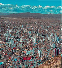
According to the National Institute of Statistics of Bolivia (INE), [1] a city is classified as an area where the city limits are identifiable, and its local government is recognized. [2] Bolivia has 1,384 cities. [3] As of 21 November 2012, the date of the most-recent national census, [4] 53 cities have a population of at least 10,000 in Bolivia, as enumerated by the INE. These 53 cities have a population of 6,162,346, accounting for 61.4% of the country's population. The largest city is Santa Cruz de la Sierra, with a population of 1,441,406, a 29.4% increase from the last census date of 5 September 2001. [5] La Guardia had the highest percentage increase, 801.5%, from 2001 to 2012.

Contents

From 2001 to 2012, Bolivia had a population increase of 21.1%. Of the 53 cities, 42 had a higher increase than 21.1%, 8 had lower increase and 3 had a small decrease. The three cities that had a negative population growth from 2001 to 2012 are La Paz (−4.1%), Yacuíba (−4.2%), and Santa Ana del Yacuma (−5.4%). With the exception of the Department of La Paz, each department's capital city is the largest city in its respective department. The Department of Santa Cruz has the most cities (18), and Pando and Chuquisaca have the least (1).

An enlargeable map of the Plurinational State of Bolivia Un-bolivia.png
An enlargeable map of the Plurinational State of Bolivia
Map showing the area of indigenous peoples in Bolivia Pueblos originarios de Bolivia.png
Map showing the area of indigenous peoples in Bolivia

List

Top five cities by population
Santa cruz skyline 48.jpg
1. Santa Cruz de la Sierra
AA flight from MIA to LPB - cruising through the Andes en route to La Paz, Bolivia - Mt Illamani (6438m) on the right - LPB airport (in El Alto) at 4160m - (24720405392).jpg
2. El Alto
Centro de La Paz al atardecer.jpg
3. La Paz
Vista Aerea de la Ciudad de Cochabamba.png
4. Cochabamba
Oruro Ciudad.jpg
5. Oruro
Key
*= Department capital
= Largest city in department
RankCity Department 2012 Census [2] 2001 Census [6] Net change
1 Santa Cruz de la Sierra*† Santa Cruz 1,441,4061,113,582+29.4%
2 El Alto La Paz 842,378647,350+30.1%
3 La Paz* La Paz 757,184789,585−4.1%
4 Cochabamba*† Cochabamba 630,587516,683+22.0%
5 Oruro*† Oruro 264,683201,332+31.5%
6 Sucre*† Chuquisaca 237,480193,876+22.5%
7 Tarija*† Tarija 179,528135,783+32.2%
8 Potosí*† Potosí 174,973132,966+31.6%
9 Sacaba Cochabamba 149,57092,581+61.6%
10 Quillacollo Cochabamba 117,85974,980+57.2%
11 Montero Santa Cruz 107,29478,294+37.0%
12 Trinidad*† Beni 101,45475,540+34.3%
13 Riberalta Beni 78,75464,511+22.1%
14 Warnes Santa Cruz 77,66817,872+334.6%
15 La Guardia Santa Cruz 77,2788,572+801.5%
16 Viacha La Paz 62,51629,108+114.8%
17 Yacuiba Tarija 61,84464,611−4.3%
18 Colcapirhua Cochabamba 51,89641,980+23.6%
19 Tiquipaya Cochabamba 49,23726,732+84.2%
20 Cobija*† Pando 42,84920,820+105.8%
21 Vinto Cochabamba 40,92014,180+188.6%
22 Guayaramerín Beni 35,76433,095+8.1%
23 Villazón Potosí 35,16728,045+25.4%
24 Yapacaní [A] Santa Cruz 32,01716,572+93.2%
25 Villamontes Tarija 30,22816,113+87.6%
26 Bermejo Tarija 29,45926,059+13.0%
27 Camiri Santa Cruz 28,85526,505+8.9%
28 Tupiza Potosí 27,30221,707+25.8%
29 Llallagua Potosí 25,16620,065+25.4%
30 San Ignacio de Velasco Santa Cruz 23,12619,401+19.2%
31 San Julián Santa Cruz 20,6876,798+204.3%
32 Huanuni Oruro 20,33615,106+34.6%
33 Punata Cochabamba 19,55914,742+32.7%
34 Cotoca Santa Cruz 19,48215,181+28.3%
35 Ascensión de Guarayos Santa Cruz 19,25413,630+41.3%
36 Achocalla La Paz 18,44210,369+77.9%
37 Mineros Santa Cruz 18,34013,282+38.1%
38 Uyuni Potosí 18,06810,551+71.2%
39 San Borja Beni 17,52016,273+7.7%
40 El Torno Santa Cruz 17,13011,879+44.2%
41 Puerto Suárez Santa Cruz 16,64311,594+43.5%
42 Portachuelo Santa Cruz 14,09111,338+24.3%
43 Caranavi La Paz 13,76612,083+13.9%
44 Rurrenabaque Beni 13,4468,479+58.6%
45 Challapata Oruro 12,6849,452+34.2%
46 Santa Ana del Yacuma Beni 12,17812,877−5.4%
47 San José de Chiquitos Santa Cruz 11,8749,322+27.4%
48 Sipe Sipe Cochabamba 11,8263,226+266.6%
49 Patacamaya La Paz 11,1978,414+33.1%
50 Puerto Quijarro Santa Cruz 11,0718,963+23.5%
51 Vallegrande Santa Cruz 10,1587,884+28.8%
52 Roboré Santa Cruz 10,09810,078+0.2%
53 San Ignacio de Moxos Beni 10,0549,590+4.8%

Notes

Related Research Articles

<span class="mw-page-title-main">Demographics of Bolivia</span>

The demographic characteristics of the population of Bolivia are known from censuses, with the first census undertaken in 1826 and the most recent in 2012. The National Institute of Statistics of Bolivia (INE) has performed this task since 1950. The population of Bolivia in 2012 reached 10 million for the first time in history. The population density is 9.13 inhabitants per square kilometer, and the overall life expectancy in Bolivia at birth is 68.2 years. The population has steadily risen from the late 1800s to the present time. The natural growth rate of the population is positive, which has been a continuing trend since the 1950s; in 2012, Bolivia's birth rate continued to be higher than the death rate. Bolivia is in the third stage of demographic transition. In terms of age structure, the population is dominated by the 15–64 segment. The median age of the population is 23.1, and the gender ratio of the total population is 0.99 males per female.

<span class="mw-page-title-main">Copán Department</span> Department in Honduras

Copán is one of the departments in the western part of Honduras. The departmental capital is the town of Santa Rosa de Copán. The department is well known for its tobacco and fine cigars.

<span class="mw-page-title-main">Atlántida Department</span> Department in Honduras

Atlántida is a department located on the north Caribbean shore of Honduras, Central America. The capital is the port city of La Ceiba.

<span class="mw-page-title-main">Colón Department (Honduras)</span> Department in Honduras

Colón is one of the 18 departments into which Honduras is divided. It was created in 1881. The departmental capital is Trujillo, and the other main city is Tocoa. Trujillo was the site of the first Catholic Mass on the American mainland, held when Christopher Columbus reached the Honduran shore in 1502.

<span class="mw-page-title-main">Cortés Department</span> Department in Honduras

Cortés is one of the 18 departments of Honduras. The department covers an area of 3,954 km² and, in 2015, had an estimated population of 1,612,762, making it the most populous in Honduras. The Merendón Mountains rise in western Cortés, but the department is mostly a tropical lowland, the Sula Valley, crossed by the Ulúa and Chamelecon rivers.

<span class="mw-page-title-main">La Paz Department (Honduras)</span> Department in Honduras

La Paz is one of the 18 political and geographic departments of Honduras. The departmental capital is the city of La Paz.

<span class="mw-page-title-main">Lempira Department</span> Department in Honduras

Lempira is one of the 18 departments in Honduras. located in the western part of the country, it is bordered by the departments of Ocotepeque and Copán to the west, Intibucá to the east, and Santa Bárbara to the north. To its south lies the El Salvador–Honduras border. The departmental capital is Gracias.

<span class="mw-page-title-main">Ocotepeque Department</span> Department in Honduras

Ocotepeque is one of the 18 departments of Honduras, Central America, located in the West and bordering both El Salvador and Guatemala. It was formed in 1906 from part of Copán department. The capital and main city is Nueva Ocotepeque.

<span class="mw-page-title-main">Santa Bárbara Department, Honduras</span> Department in Honduras

Santa Bárbara is one of the 18 departments (departamentos) into which Honduras is divided. The departmental capital is Santa Bárbara.

<span class="mw-page-title-main">Departments of Bolivia</span> First-level administrative divisions of Bolivia

Bolivia is a unitary state consisting of nine departments. Departments are the primary subdivisions of Bolivia, and possess certain rights under the Constitution of Bolivia. Each department is represented in the Plurinational Legislative Assembly—a bicameral legislature consisting of the Senate and the Chamber of Deputies. Each department is represented by four Senators, while Deputies are awarded to each department in proportion to their total population.

<span class="mw-page-title-main">Greater Buenos Aires</span> Urban agglomeration in Argentina

Greater Buenos Aires, also known as the Buenos Aires Metropolitan Area, refers to the urban agglomeration comprising the Autonomous City of Buenos Aires and the adjacent 24 partidos (districts) in the Province of Buenos Aires. Thus, it does not constitute a single administrative unit. The conurbation spreads south, west and north of Buenos Aires city. To the east, the River Plate serves as a natural boundary.

El Corpus is a municipality in the Honduran department of Choluteca.

Japanese Bolivians are Bolivians of Japanese ancestry or Japanese-born people who reside in Bolivia.

<span class="mw-page-title-main">Totora, Cochabamba</span> Town in Cochabama, Bolivia

Totora, Tutura or T'utura is a town in the Carrasco Province of the Cochabamba Department in Bolivia. It is the capital and most-populous place of the Totora Municipality. As of the 2012 census, the population is 1,925. The first settlers were Inca Indians. Totora was officially settled in 1876, and declared a town by the Government of Bolivia in 1894.

<span class="mw-page-title-main">Chané</span> Indigenous people of South America

Chané is the collective name for the southernmost Arawakan-speaking peoples. They lived in the plains of the northern Gran Chaco and in the foothills of the Andes in Paraguay, Brazil, Bolivia, and Argentina. The historical Chané are divided into two principal groups. The Chané proper who lived in eastern Bolivia and the Guaná who lived in Paraguay and adjacent Brazil. Twenty-first century survivors of the Chané are the Izoceno people of Bolivia and 3,034 descendants reported in Argentina by the 2010 census. Survivors of the Guaná are the Tereno and the Kinikinao both of Mato Grosso do Sul province in Brazil.

<span class="mw-page-title-main">Yapacaní</span> Town in Santa Cruz Department, Bolivia

Yapacaní is the largest city in the province of Ichilo in the Bolivian department of Santa Cruz. It lies on the west bank of the Yapacani River, at the mouth of the Surutú River, 100 km north-west of Santa Cruz de la Sierra, the largest city in Bolivia. It is the centre of the district of Yapacaní Municipio. Prior to its foundation on 23 August 1953, there was a military post called El Comando.

<span class="mw-page-title-main">Aucapata Municipality</span> Municipality in La Paz Department, Bolivia

Aucapata Municipality is municipality of the Muñecas Province in the La Paz Department, Bolivia. Its capital is Aucapata.

<span class="mw-page-title-main">Bolivians</span> People identified with the country of Bolivia

Bolivians are people identified with the country of Bolivia. This connection may be residential, legal, historical or cultural. For most Bolivians, several of these connections exist and are collectively the source of their being Bolivian.

<span class="mw-page-title-main">Chiquitano</span> Indigenous people of Bolivia, with a small number also living in Brazil

The Chiquitano or Chiquitos are an indigenous people of Bolivia, with a small number also living in Brazil. The Chiquitano primarily live in the Chiquitania tropical savanna of Santa Cruz Department, Bolivia, with a small number also living in Beni Department and in Mato Grosso, Brazil. In the 2012 census, self-identified Chiquitanos made up 1.45% of the total Bolivian population or 145,653 people, the largest number of any lowland ethnic group. A relatively small proportion of Bolivian Chiquitanos speak the Chiquitano language. Many reported to the census that they neither speak the language nor learned it as children. The Chiquitano ethnicity emerged among socially and linguistically diverse populations required to speak a common language by the Jesuit Missions of Chiquitos.

Warázu, also known as Pauserna or Guarasugwé (Guarasú'we), is a moribund Tupi–Guaraní language of Brazil. It was also formerly spoken in Bolivia. It is spoken by the Guarasugwé people, who were estimated to number 125 according to a census in 2012.

References

  1. "Instituto Nacional de Estadística". INE.
  2. 1 2 "Ciudades/Comunidades/Centros Poblados a Localidades Empadronadas en el Censo de Población y Vivienda 2012" [Cities/Communities/Towns and Villages Centers Enumerated in the Census of Population and Housing 2012] (in Spanish). National Institute of Statistics of Bolivia . Retrieved 2 February 2014.
  3. "Bolivia" (in Spanish). UNESCO. 11 April 2013. Retrieved 22 February 2014.
  4. "El Gobierno Realizará el Censo 2012 el 21 de Noviembre" [The Government will make the 2012 Census on 21 November]. Los Tiempos (in Spanish). 19 April 2011. Archived from the original on 1 February 2014. Retrieved 10 February 2014.
  5. National Institute of Statistics of Bolivia (2003). "Bolivia: Niveles, Tendencias y Diferenciales de la Fecundidad" [Bolivia: Levels, Trends and Differentials of Fertility](PDF) (in Spanish). National Institute of Statistics of Bolivia. p. 11. Archived from the original (PDF) on 24 September 2015. Retrieved 10 February 2014.
  6. "Censo de Poblacion y Vivienda – 2001" [Census of Population and Housing – 2001] (in Spanish). National Institute of Statistics of Bolivia. 2 November 2001. Retrieved 22 December 2013.
  7. "Censo de Poblacion y Vivienda – 2001: Bolivia: Santa Cruz Departamento: Ichilo Provincia: Yapacaní Municipales" [Census of Population and Housing – 2001: Santa Cruz Department: Ichilo Province: Yapacaní Municipality] (in Spanish). National Institute of Statistics of Bolivia. 2 November 2011. Retrieved 16 February 2014.
  8. "Censo de Poblacion y Vivienda 2012: Santa Cruz Departamento: Ichilo Provincia: Yapacaní Municipales" [Census of Population and Housing 2012: Santa Cruz Department: Ichilo Province: Yapacaní Municipality]. National Institute of Statistics of Bolivia . Retrieved 16 February 2014.