List of glaciers in India

Last updated

Parkachik Glacier, Nun Kun Massif Parkachik Glacier, Nun Kun Massif.jpg
Parkachik Glacier, Nun Kun Massif

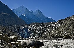
The Himalayan region of India is home to some of the most notable glaciers in the world, including the Siachen Glacier, the second-largest non-polar glacier on Earth and the largest glacier in India. The following is a list of the most important glaciers in India. Most glaciers lie in the union territory of Ladakh and the states of Himachal Pradesh, Sikkim, and Uttarakhand.

Contents

A few glaciers are also found in Arunachal Pradesh.

List of Indian glaciers

Arunachal Pradesh

In Arunachal Pradesh, glaciers are found in Great Himalayas ranges which run along the Tibetan border. All peaks here rise above 4500 meters and are snow covered throughout the year.

Important glaciers include:

Himachal Pradesh

Sikkim

Union Territory of Ladakh

Nun Kun Massif Parkachik Glacier 2.jpg
Nun Kun Massif
Parkachik Parkachik Glacier 3.jpg
Parkachik
Drang-Drung-Glacier Drang-Drung-Glacier.jpg
Drang-Drung-Glacier

Uttarakhand

Goumukh, terminus of the Gangotri glacier. The Bhagirathi peaks rise in the background. Gomukh the source of Ganga.jpg
Goumukh, terminus of the Gangotri glacier. The Bhagirathi peaks rise in the background.

See also

Related Research Articles

<span class="mw-page-title-main">Nanda Devi</span> Second-highest mountain in India

Nanda Devi is the second-highest mountain in India, after Kangchenjunga, and the highest located entirely within the country. Nanda Devi is the 23rd-highest peak in the world.

Oropolitics comes from the Greek oros meaning mountain and politikos meaning citizen. In modern usage it denotes the use of mountaineering for political purposes.

The Nanda Devi National Park or Nanda Devi Biosphere Reserve, established in 1982 is a national park situated around the peak of Nanda Devi in Chamoli Garhwal district of Uttarakhand, in northern India. The entire park lies at an elevation of more than 3,500 m (11,500 ft) above mean sea level.

<span class="mw-page-title-main">Geography of Himachal Pradesh</span>

The state of Himachal Pradesh is spread over an area 55,673 km2 (21,495 sq mi) and is bordered by Jammu and Kashmir and Ladakh on the north, Punjab on the southwest, Haryana on the south, Uttarakhand on the southeast, a small border with Uttar Pradesh in the south, and Tibet on the east. Entire Himachal Pradesh lies in the mountainous Himalaya region, rich in natural resources

<span class="mw-page-title-main">Gori Ganga</span> River in Uttarakhand, India

Gori Ganga is a river in the Munsiari tehsil of the Pithoragarh District, part of the state of Uttarakhand in northern India. Its principal source is the Milam Glacier, just northeast of Nanda Devi along with the Glaciers of the Ralam River, and the Pyunshani and Uttari & Dakshini Balati Glaciers that lie on the western face of the Panchachuli Peaks.

<span class="mw-page-title-main">Indian Himalayan Region</span> Region in northern India

The Indian Himalayan Region is the section of the Himalayas within the Republic of India, spanning thirteen Indian states and union territories, namely Ladakh, Jammu and Kashmir, Himachal Pradesh, Uttarakhand, Sikkim, West Bengal, Manipur, Meghalaya, Mizoram, Nagaland, Tripura, Assam, and Arunachal Pradesh. The region is responsible for providing water to a large part of the Indian subcontinent and contains various flora and fauna.

<span class="mw-page-title-main">Bara Shigri Glacier</span>

Bara Shigri is a glacier located in Lahaul & Spiti, Himachal Pradesh, India. It is currently extending to 27.7 kilometres and covers over 126.45 square kilometres. It is the largest glacier in Himachal Pradesh.

<span class="mw-page-title-main">Garhwal Himalayas</span> Mountain ranges in India

The Garhwal Himalayas are mountain ranges located in the Indian state of Uttarakhand.

Colonel Narendra Kumar, PVSM, KC, AVSM, FRGS was an Indian soldier and mountaineer. He is known for his expeditions across various mountain ranges such as the Himalayas and Karakorams, and respective subranges such as the Pir Panjals and Saltoro Mountains. His reconnaissance efforts on the Siachen glacier were key to the Indian Army's reclamation of the forward posts of the glacier in Operation Meghdoot in 1984. He was the deputy leader of the first successful Indian Mount Everest expedition in 1965.

<span class="mw-page-title-main">Kalanka</span> Mountain in Garhwal Himalaya

Kalanka is a mountain of the Garhwal Himalayas in Uttarakhand, India. Kalanka stands at 6,931 metres (22,740 ft). It's the 20th highest located entirely within the Uttrakhand. Nanda Devi is the highest mountain in this category. Kalanka is the 48th highest peak in India and 319th highest peak in the world. Southern side of Kalanka falls under Nanda Devi National Park.

Saf Minal is a mountain of Garhwal Himalaya in Uttarakhand India. Saf Minal standing majestically at 6911 meter 22674 feet. It's the 21st highest located entirely within the uttrakhand India. Nanda Devi, is the highest mountain in this category and 50th highest peak in India. Saf Minal is the 332nd highest peak in the world. Saf Minal falls on the edge of the Northern Nanda Devi National Park.

<span class="mw-page-title-main">Maiktoli</span>

Maiktoli is a mountain of Kumaun Himalayas located in the Bageshwar district of Uttarakhand state in India. It stands at 6,803 metres (22,320 ft). It is jointly the 32nd highest located entirely within the uttrakhand India. Nanda Devi is the highest mountain in this category. Maiktoli is 479th highest peak in the world. It is located at the southern rim of Nanda Devi Sanctuary. Maiktoli is located just south east of Devtoli and south east of Trisul. On the north east side lies Nanda Devi and Panwali Dwar. On the south west side lies Tharkot.

Saraswati Parbat II is a mountain of the Garhwal Himalaya in Uttarakhand India.The elevation of Saraswati Parbat II is 6,775 metres (22,228 ft) and its prominence is 551 metres (1,808 ft). It is 37th highest located entirely within the Uttrakhand. Nanda Devi, is the highest mountain in this category. It falls under Kamet Zaskar Range. It lies between Saraswati Parbat I and Chamrao Parbat I It lies 3.1 km NNW of Chamrao Parbat I 6,910 metres (22,671 ft). Its nearest higher neighbor Saraswati Parbat I 6,940 metres (22,769 ft). It is located 9.1 km NNW of Mukut Parbat 7,242 metres (23,760 ft) and 7.1 km west lies Balbala 6,416 metres (21,050 ft).

Bidhan Parbat is a mountain of the northern Garhwal Himalaya in Uttarakhand India.The elevation of Bidhan Parbat is 6,520 metres (21,391 ft) and its prominence is 234 metres (768 ft). It is 84th highest located entirely within the Uttrakhand. Nanda Devi, is the highest mountain in this category. It is situated in the Zaskar Range. It lies 3 km west of Deoban 6,855 metres (22,490 ft) its nearest higher neighbor. Mandir Parbat 6,559 metres (21,519 ft) lies 8.3 km SW and it is 10.4 km SE of Kamet 7,756 metres (25,446 ft). It lies 6.6 km SE of Mana Peak 7,272 metres (23,858 ft).

Deo Damla is a mountain of the Garhwal Himalaya in Uttarakhand, India. It is situated in the eastern rim of Nanda Devi Sanctuary on the watershed of Milam Glacier and Nanda Devi basin. The elevation of Deo Damla is 6,620 metres (21,719 ft) and its prominence is 693 metres (2,274 ft). It is 63rd highest located entirely within the Uttrakhand. Nanda Devi, is the highest mountain in this category. It lies 1.8 km SSE of Mangraon 6,568 metres (21,549 ft). Its nearest higher neighbor Rishi Pahar 6,992 metres (22,940 ft) lies 8.3 km NNW and it is 10.6 km SSW of Nanda Devi 7,816 metres (25,643 ft). It lies 1.4 km north of Bamchu 6,303 metres (20,679 ft).

Lhatu Dhura is a mountain of the Garhwal Himalaya in Uttarakhand, India. It is situated in the eastern rim of the Nanda Devi Sanctuary, on the watershed of the Milam Glacier and the Nanda Devi basin. The elevation of Lhatu Dhura is 6,392 metres (20,971 ft) and its prominence is 229 metres (751 ft). It is joint 103rd highest mountain located entirely within Uttrakhand. It lies 4.6 km south of Sakram 6,254 metres (20,518 ft). Its nearest higher neighbor Nanda Devi East lies 4.5 km to the south west, and Deo Damla lies 7.7 km to the north; it is 6.1 km east-north-east of Nanda Devi, and 9.5 km south of Mangraon.

Dakshini Nanda Devi Glacier is a glacier in Chamoli district, Uttarakhand, India. With Uttari Nanda Devi Glacier, Dakshini Nanda Devi Glacier flanks Nanda Devi peak and also feeds the Rishiganga river. Nanda Khat is also near.

<span class="mw-page-title-main">Rishiganga</span> River in Uttarakhand, India

Rishiganga is a river in the Chamoli district, Uttarakhand, India. It springs from the Uttari Nanda Devi Glacier on the Nanda Devi mountain. It is also fed from the Dakshini Nanda Devi Glacier. Continuing through the Nanda Devi National Park, it flows into the Dhauliganga River near the village Rini.

References

  1. "Glaciers in Himachal Pradesh" . Retrieved 2 August 2019.
  2. Inventory of Himachal Pradesh Glaciers (http://14.139.224.135/myapp/cgrt/index_files/Project_Reports_Completed/CGRT4.Misc.595-15-HP%20Himalya%20Inventory%20of%20Glaciers(GLOF)---03-06.pdf)