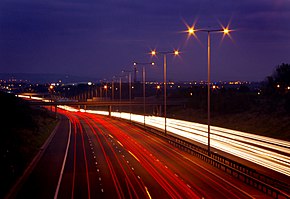
The M25 or London Orbital Motorway is a major road encircling almost all of Greater London, England. The Dartford Crossing (A282) is part of the orbital route but is not part of the motorway. The M25 is one of the most important roads in Britain and one of the busiest. The final section was opened by the Prime Minister Margaret Thatcher in 1986; on opening it was the longest ring road in Europe at 117 miles (188 km).

The M6 motorway runs from junction 19 of the M1 and the western end of the A14 at the Catthorpe Interchange, near Rugby and Coventry via Birmingham and then heads north, passing Wolverhampton, Stoke-on-Trent, Liverpool, Manchester, Preston, Lancaster, Carlisle and terminating at the Gretna junction (J45). Here, just short of the Scottish border it becomes the A74(M) which continues to Glasgow as the M74. Its busiest sections are J4-10a at Birmingham and J16-19 in Cheshire as this forms the main route from the East/West Midlands and London to Manchester and Liverpool, These sections are now Smart Motorway.

The M1 motorway connects London to Leeds, where it joins the A1(M) near Aberford, to connect to Newcastle. It was the first inter-urban motorway to be completed in the UK; the first motorway in the country was the Preston By-pass, which later became part of the M6.
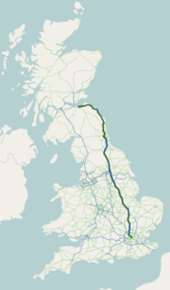
The A1 is the longest numbered road in the UK, at 410 miles (660 km). It connects London, the capital of England, with Edinburgh, the capital of Scotland. It passes through or near North London, Hatfield, Welwyn Garden City, Stevenage, Baldock, Letchworth Garden City, Huntingdon, Peterborough, Stamford, Grantham, Newark-on-Trent, Retford, Doncaster, York, Ripon, Darlington, Durham, Sunderland, Gateshead, Newcastle upon Tyne, Alnwick and Berwick-upon-Tweed.

The M40 motorway links London, Oxford and Birmingham in England, a distance of approximately 89 miles (143 km).

The M62 is a 107-mile-long (172 km) west–east trans-Pennine motorway in Northern England, connecting Liverpool and Hull via Manchester and Leeds; 7 miles (11 km) of the route is shared with the M60 orbital motorway around Manchester. The road is part of the unsigned Euroroutes E20 and E22.
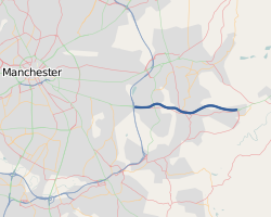
The M67 is a 5-mile (8.0 km) urban motorway in Greater Manchester, England, which heads east from the M60 motorway passing through Denton and Hyde before ending near Mottram. It was originally conceived as the first part of a trans-Pennine motorway between Manchester and Sheffield connecting the A57(M) motorway to the M1 motorway; however, the motorway never progressed this far.

The M20 is a motorway in Kent, England. It follows on from the A20 at Swanley, meeting the M25, and continuing on to Folkestone, providing a link to the Channel Tunnel and the ports at Dover. It is 50.6 miles (81.4 km) long. Although not signposted in England, this road is part of the European route E15.

The M56 motorway, also known as the North Cheshire motorway, is in Cheshire and Greater Manchester, England. It runs from Junction 4 of the M60 to Dunkirk, near Chester. With a length of 33.3 miles (53.6 km), it is often busy with long-distance commuter traffic towards North Wales. It serves commuters heading to Manchester, particularly those from the wider Cheshire area, and gives access to Manchester Airport from the national motorway network.

The A66 is a major road in Northern England, which in part follows the course of the Roman road from Scotch Corner to Penrith. It runs from east of Middlesbrough in the ceremonial county of North Yorkshire to Workington in Cumbria. It is anomalously numbered since west of Penrith it trespasses into numbering zone 5; this is because it originally terminated at the A6 in Penrith but was extended further west in order to create one continuous east–west route. Most of what is now the A66 west of Penrith was originally A594 – only a small stub of this road numbering remains, from Maryport to Cockermouth.

The A14 is a trunk road in England, running 127 miles (204 km) from the Port of Felixstowe, Suffolk to its western end at the Catthorpe Interchange; a major intersection at the southern end of the M6 and junction 19 of the M1 in Leicestershire. The road forms part of the unsigned Euroroutes E24 and E30.

The M65 is a motorway in Lancashire, England. It runs from just south of Preston through the major junction of the M6 and M61 motorways, east past Darwen, Blackburn, Accrington, Burnley, Brierfield, Nelson and ends at Colne.

The M61 is a motorway in North West England. It runs from the M60 motorway northwest of Manchester and heads northwest past Bolton and Chorley to join the M6 just north of the junction between the M6 and M65 motorways to the south of Preston.

The M7 motorway is a motorway in Ireland. The motorway runs continuously from the outskirts of Naas in County Kildare to Rossbrien on the outskirts of Limerick City. The M7 forms part of the Dublin to Limerick N7 national primary road. The section of the motorway bypassing Naas, an 8 km stretch, was the first section of motorway to open in the Republic of Ireland, in 1983. Following substantial works to extend the M7 to Limerick; by the end of 2010, the motorway replaced all of the old single-carriageway N7 route which is now designated as R445. At 166.5 km, the M7 is the longest motorway in Ireland.

The M66 is a motorway in Lancashire and Greater Manchester, England. It is 8 miles (13 km) long and provides part of the route between the M62 and M60 motorways and the M65, with the rest being provided by the A56.

The Mancunian Way is a two mile long grade separated elevated motorway in Manchester, England. It is officially made up of the A57(M) and A635(M) motorways, although the latter does not appear on road signs for practical reasons. It is also part of two other roads: the A57 to the west, which runs east–west through Greater Manchester linking the M602 and M67 motorways, and a short section of non-motorway A635 to the east. Part of this non-motorway section collapsed on 14 August 2015 due to a sinkhole.
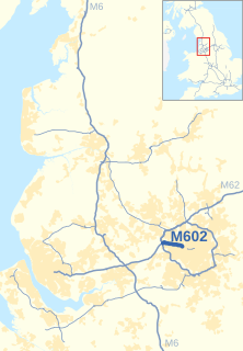
The M602 motorway is a relatively short motorway, leading traffic into Salford, Greater Manchester, England, towards Manchester and by-passing the suburban town of Eccles.

The M606 is a short stretch of motorway in West Yorkshire, England. Called the Bradford Spur motorway, the M606 leaves the M62 motorway at junction 26, near Cleckheaton, and heads into Bradford, to join the A6177 Bradford Ring Road. It is officially named the "Bradford South Radial Motorway" and was opened in 1973.

The M63 motorway was a major road in the United Kingdom. It was completely renumbered as part of the M60 motorway in 1999 which orbits part of Greater Manchester.
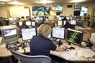
A smart motorway, also known in Scotland as an intelligent transport system, is a section of motorway that uses active traffic management (ATM) techniques to increase capacity by use of variable speed limits and hard shoulder running at busy times. Benefits include smoother traffic flow, more reliable journey times, fewer road traffic collisions, and reduced noise and harmful vehicle emissions. The term controlled motorway is sometimes used for schemes that use variable speed limits without hard-shoulder running.

