Campbell County is a United States county situated in the south central part of the Commonwealth of Virginia. Located in the Piedmont region of Virginia, Campbell borders the Blue Ridge Mountains. The county seat is Rustburg. Grounded on a tobacco cash crop economy, Campbell County was created in 1782 from part of Bedford County. The county was named in honor of General William Campbell, hero of the American Revolutionary War. Campbell County is part of the Lynchburg metropolitan area. At the 2020 census, the county population was 55,696. The number of residents has grown steadily in every census after 1930, and the total population has more than doubled since that time. Lynchburg was established in Campbell County in 1786, incorporated as a town in 1805, and separated from Campbell County when it became an independent city in 1852. Lynchburg has annexed additional land from Bedford County and Campbell County through the years, most recently in 1976.
Stokes County is a county located in the U.S. state of North Carolina. As of the 2020 census, the population was 44,520. Its county seat is Danbury.

Jackson County is a county located in the Commonwealth of Kentucky. As of the 2020 census, the population was 12,955. Its county seat is McKee. The county was formed in 1858 from land given by Madison, Estill, Owsley, Clay, Laurel, and Rockcastle counties. It was named for Andrew Jackson, seventh President of the United States. Jackson County became a moist county via a "local-option" referendum in the Fall of 2019 that legalized the sale of alcoholic beverages in the city of McKee.
Annville is an unincorporated community, a census-designated place (CDP), and the largest community in Jackson County, KY. As of the 2020 census, the population was 1,102. The community was established in 1878 and named for local resident Nancy Ann Johnson. The community offers a few services such as a post office, grocery store, gas station, medical clinic, nursing home, restaurants, and other locally owned businesses.
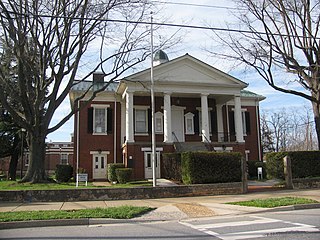
McKee is a home rule-class city located in the Commonwealth of Kentucky. It is the seat and second-largest community of Jackson County, KY. As of the 2020 census, the population of the city was 803. The city was founded on April 1, 1882, and was named for Judge George R. McKee. In 2019, the city held a vote regarding the sale of alcohol, which passed, making the city wet.

McKees Rocks, also known as "The Rocks", is a borough in Allegheny County in Western Pennsylvania, United States, along the south bank of the Ohio River. Part of the Pittsburgh metropolitan area, its population was 5,920 at the time of the 2020 census.

Evangelical Friends Church International (EFCI) is a branch of the Society of Friends (Quaker) yearly meetings located around the world. This branch makes up most Evangelical Quaker meetings from the Gurneyites. The EFCI is generally more conservative in their orientation than other Quaker meetings and has many similarities to other denominations of Evangelicalism. The original EFCI, known as the Association of Evangelical Friends, was formed in 1947. The EFCI adopted its current name in 2004 and is a member of the National Association of Evangelicals and the World Evangelical Alliance. Despite their differences from other Friends, they are a member of the interdenominational Friends World Committee for Consultation. After the switching of around 7,000 Friends from the Friends United Meeting in California to the EFCI, Evangelical Friends became the largest branch of Friends in the United States.

Quaker Hill is a village or neighborhood in the town of Waterford, in the southeastern part of Connecticut, USA.

South Table Mountain is a mesa on the eastern flank of the Front Range of the Rocky Mountains of North America. Castle Rock, the 6,338-foot (1,932 m) summit of the mesa, is located on private property in Jefferson County, Colorado, 0.56 miles (0.9 km) directly east of downtown Golden.

William McKee Dunn was a U.S. Representative from Indiana and the Judge Advocate General of the United States Army.
Quaker Hill is a hamlet in the town of Pawling in Dutchess County, New York, United States. The community shares its name with the twelve-mile-long ridge on which it is located; the ridge is located near the Connecticut state line. Quaker Hill is in the southern portion of the area known as the "Oblong" that was designated by the Treaty of Dover in 1731, and "known from pre-Revolutionary times as Quaker Hill". In colonial times, Quaker Hill separated "the English [settlers] of New England and the Hudson Valley Dutch population."

Stephen F. Austin High School is a high school in El Paso, Texas. Austin opened in 1930. It is part of the El Paso Independent School District. The school's mascot is a golden panther named "Henry." Austin High School is located in the heart of historic Central El Paso and serves the Central community.

McCauley Mountain is a summit and ski resort in the Town of Webb, Herkimer County, New York. It is located just outside the hamlet of Old Forge, in the south-western area of the Adirondack Mountains.

The Aermotor Windmill Company, or Aermotor Company, is an American manufacturer of wind-powered water pumps. The widespread use of their distinctive wind pumps on ranches throughout the arid plains and deserts of the United States has made their design a quintessential image of the American West.
Quaker City is an unincorporated community in Albany Township in Berks County, Pennsylvania, United States. Quaker City is located along Quaker City Road at the base of Blue Mountain.

Dunning Mountain is a stratigraphic ridge in central Pennsylvania, United States. The mountain's north end is at McKee Gap, which separates it from Short Mountain, and where Halter Creek flows westward towards the Frankstown Branch of the Juniata River. The south end of the mountain is contiguous with Evitts Mountain, but is marked by a sharp bend to the east. The valley formed by the bend is known as "The Kettle," and the broad valley to the east of Dunning Mountain is called Morrisons Cove. The town of Roaring Spring is located at the north end of the mountain on the east side.
McCarty Hill is a mountain in the Southern Tier of New York. It is located in Cattaraugus County, mostly in Little Valley and Great Valley, with portions in Ellicottville and Mansfield. In 1940, an 82-foot-6-inch-tall (25.15 m) steel fire lookout tower was built on the mountain. The tower ceased fire lookout operations and then officially closed in early 1989. In 1993, the tower was dismantled and removed and replaced with a free-standing communications tower.
McKee is an unincorporated community and census-designated place (CDP) in Blair County, Pennsylvania, United States. It was first listed as a CDP prior to the 2020 census.
Vicksburg is an unincorporated community and census-designated place (CDP) in Blair County, Pennsylvania, United States. It was first listed as a CDP prior to the 2020 census.
Mount Tuscarora is a mountain in the Southern Tier of New York. It is in Allegany State Park in Coldspring, Cattaraugus County. In 1928, a 60-foot-tall (18 m) steel fire lookout tower was built on the mountain. The tower remains on the mountain but needs to be restored. The peak is the tallest in the Allegany State Park among those that have a trail to the summit, at 2,144 ft above sea level.

