Weld is a town in Franklin County, Maine, United States. The population was 376 at the 2020 census. Set beside Webb Lake and almost surrounded by mountains, Weld is noted for its scenery. It is home to Mount Blue State Park, Camp Kawanhee for Boys, and Camp Lawroweld.

Ohio is a town in Herkimer County, New York, United States. The population was 1,002 at the 2010 census. The town is named after the state of Ohio. The town is in the northern part of the county and northeast of Utica. Part of Ohio is within the Adirondack Park.

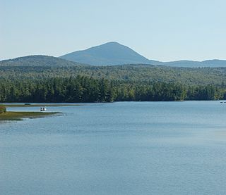
Webb is the northernmost town in Herkimer County, New York, United States. As of the 2010 census it had a population of 1,807.
The Victory Mountains are a major group of mountains in Victoria Land, Antarctica, about 100 nautical miles long and 50 nautical miles wide, which is bounded primarily by Mariner and Tucker glaciers and the Ross Sea. They are north of the Mountaineer Range, east of the Freyberg Mountains and south of the Concord Mountains and the Admiralty Mountains. The division between the Victory Mountains and the Concord Mountains is not precise but apparently lies in the vicinity of Thomson Peak.

Mars Hill University is a private Christian university in Mars Hill, North Carolina. The university offers 35 undergraduate majors and includes a school of nursing and graduate schools in education, criminal justice, and management. From 1859 to 2013 the school was called Mars Hill College; in August 2013 it officially changed its name to Mars Hill University.

Webb Hill is a hill located in St. George, Utah, in Washington County. The hill houses numerous radio and television tower facilities that serve the local area. The hill's geology is common with the surrounding region. In 1998, the skeletal remains of a male were found on the mountain.

McCauley Mountain is a summit and ski resort in the Town of Webb, Herkimer County, New York. It is located just outside the hamlet of Old Forge, in the south-western area of the Adirondack Mountains.
Moose Mountain (10,059 feet is located in the northern Teton Range in the U.S. state of Wyoming. The peak is on the border of Grand Teton National Park and the Jedediah Smith Wilderness of Caribou-Targhee National Forest. Moose Mountain is at the western end of Webb Canyon.

Owl Peak is in the northern Teton Range, Grand Teton National Park, Wyoming and is just east of Elk Mountain. The peak is located west of and across Jackson Lake from Lizard Creek Campground. Access to the peak is easiest by boat to the Berry Creek Trailhead at Wilcox Point then heading west at the Owl Creek Trail. After a 2 miles (3.2 km) hike along Berry Creek and Owl Creek trails, off trail access to the summit can be achieved after a steep ascent of an additional 2 miles (3.2 km). North of the mountain, the Tetons blend into the Yellowstone Plateau while to the south lies Webb Canyon.

Wheeler Springs is an unincorporated community that grew around a set of sulphurated hot springs in Ventura County, California. It is located 6 miles north of the Ojai Valley, within Los Padres National Forest. It is named for Wheeler Blumberg, who founded the town in 1891, and the many natural hot springs.
Moose River Mountain is a 2,208-foot-tall (673 m) mountain in the Adirondack Mountains of New York. It is located west of Old Forge in the town of Webb in Herkimer County. In 1919, a 60-foot-tall (18 m) steel fire lookout tower was built on the mountain. The tower ceased fire lookout operations at the end of the 1970, and was later removed in 1977.
Stillwater Mountain is a 2,244-foot-tall (684 m) mountain in Adirondack Mountains of New York. It is located south of Stillwater in the town of Webb in Herkimer County. In 1919, a 47-foot-tall (14 m) steel fire lookout tower was built on the mountain. At the end of the 1988 fire lookout season, the tower ceased fire lookout operation. The tower was restored and is open to the public except from the second Tuesday in October through December 20.
Woodhull Mountain is a 2,359-foot-tall (719 m) mountain in the Adirondack Mountains of New York. It is located east-southeast of Minnehaha in the Town of Webb in Herkimer County. In 1916, a 50-foot-tall (15 m) steel fire lookout tower was built on the mountain. The tower ceased fire lookout operations at the end of the 1970 season. The tower still remains and is open to the public with the exception of the tower cab.
McKee Hill is a mountain located in the Catskill Mountains of New York, west of North Kortright. Quaker Hill is located northeast; Webb Hill and Dutch Hill are located northwest; while Gunhouse Hill is located east of Quaker Hill.
Dutch Hill is a mountain located in the Catskill Mountains of New York east of Davenport Center. Webb Hill is located northwest, and Mine Hill is located southwest of Dutch Hill.
Red Hill is a mountain located in the Catskill Mountains of New York east-south of Frost Valley. Woodhull Mountain is located northeast of Red Hill.
Gallis Hill is a 794-foot-tall (242 m) mountain in the Catskill Mountains region of New York. It is located northwest of Kingston in Ulster County. Jockey Hill is located north-northeast, and Morgan Hill is located west of Gallis Hill. In 1927, the Conservation Department built a steel fire lookout tower on the mountain. In 1950, the tower was closed and disassembled then moved to Overlook Mountain, where it still remains today.
Maple Hill is a summit located in Central New York Region of New York located in the Town of Webb in Herkimer County, north-northwest of Stillwater Reservoir. Alder Bed Mountain is located southeast of Maple Hill.
Alder Bed Mountain is a summit located in Central New York Region of New York located in the Town of Webb in Herkimer County, north-northwest of Stillwater Reservoir. Maple Hill is located northwest and The Hogs Back is located west-southwest of Alder Bed Mountain.
Mount Electra is a 2,260-foot-tall (690 m) mountain in the Adirondack Mountains of New York. It is located north-northeast of Little Rapids in the Town of Webb in Herkimer County. Deer Mountain is located north-northwest of Mount Electra. The mountain was previously known as Rock Lake Mountain. Around 1920, a 60-foot-tall (18 m) steel fire lookout tower was built on the mountain. The tower was dismantled in 1989 and left at the mountain top.

