
Kampala is the capital and largest city of Uganda. The city proper has a population of 1,875,834 (2024) and is divided into the five political divisions of Kampala Central Division, Kawempe Division, Makindye Division, Nakawa Division, and Rubaga Division.

Sir Edward Frederick William David Walugembe Mutebi Luwangula Mutesa II was Kabaka, or king, of the Kingdom of Buganda in Uganda from 22 November 1939 until his death. He was the 35th Kabaka of Buganda and the first president of Uganda from 1962 to 1966, when he was overthrown by Milton Obote. The foreign press often referred to him as King Freddie, a name rarely used in Uganda. An ardent defender of Buganda's interests, especially its traditional autonomy, he often threatened to make the kingdom independent both before and after Uganda's independence to preserve it. These firm convictions also later led to conflicts with his erstwhile political ally Milton Obote, who would eventually overthrow him.

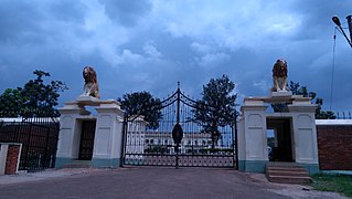
Lubiri is the royal compound of the Kabaka or king of Buganda, located in Mengo, a suburb of Kampala, the Ugandan capital. The original Lubiri was destroyed in the May 1966 Battle of Mengo Hill, at the culmination of the struggle between Mutesa II and Milton Obote for power.
The Buganda Crisis, also called the 1966 Mengo Crisis, the Kabaka Crisis, or the 1966 Crisis, domestically, was a period of political turmoil that occurred in Buganda. It was driven by conflict between Prime Minister Milton Obote and the Kabaka of Buganda, Mutesa II, culminating in a military assault upon the latter's residence that drove him into exile.
St. Lawrence University is a private university in Kampala, Uganda.
Lubaga is a hill in Kampala, Uganda's capital and largest city. It comes from the Luganda word okubaga, describing a process of "planning" or "strengthening" a structure while constructing it. For example, okubaga ekisenge means to strengthen the internal structure of a wall while building a house. The name also applies to the neighborhood on the hill.
Rubaga Division, also Lubaga Division, is one of the divisions that makes up the city of Kampala, Uganda. The division takes its name from Rubaga, where the division headquarters are located.
Prince Daudi Kintu Wasajja also called David Wasajja is a prince of Buganda, the largest traditional kingdom in Uganda.
Namirembe is a hill in Kampala, Uganda's capital and largest city. It is also a common name given to girls in several Baganda clans. Namirembe comes from the Luganda word "mirembe" meaning peace. Namirembe loosely translates into Full of Peace. Legend has it that this hill was a gathering place for celebrating peace or war victories.
Banda is a hill that lies in Nakawa Division, within Kampala, the capital of Uganda. Banda also refers to the neighborhoods on the slopes of the hill and between Banda Hill and Kireka, extending all the way to the Kampala-Jinja Highway. The southwestern slopes of the hill are occupied by the neighbourhood known as Kyambogo, and is the location of the campus of Kyambogo University, one of the nine public universities in the country.
Kasubi is a hill in Kampala, Uganda's capital and largest city.
Mengo Hospital, also known as Namirembe Hospital, is a private, faith-based, community, teaching hospital in Kampala, the capital and largest city of Uganda.

The Bulange (boo-lah-ngeh) is a building in Uganda. It houses the Lukiiko (Parliament) of the Kingdom of Buganda. The Kabaka of Buganda and the Katikkiro of Buganda also maintain offices in the building. The building serves as the administrative headquarters of the Buganda Kingdom.
Mengo Senior School, also known as Mengo SS, is a comprehensive, mixed day school in Kampala. As of March 2020, it had over 5300 students, 250 teachers, 28 technical staff, and more than 30 support staff.
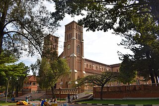
Saint Paul's Cathedral Namirembe, commonly referred to as Namirembe Cathedral, is the oldest cathedral in Uganda. It serves as the provincial cathedral of the Anglican Church of Uganda and the diocesan cathedral for Namirembe Diocese, the first diocese to be founded in the Church of Uganda province in 1890. Between 1919 and 1967, the Cathedral served as the provincial cathedral of the Church of Uganda, Anglican Communion. In the 1960s, the headquarters of the Church of Uganda moved to All Saints Church in Nakasero then moved back to Namirembe later.

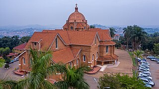
Saint Mary's Cathedral Rubaga, commonly referred to as Rubaga Cathedral, is the parent cathedral of the Roman Catholic Archdiocese of Kampala, the oldest Roman Catholic diocese in Uganda. It is the home church of Archbishop of Kampala.
Buganda Investments and Commercial Undertakings Limited(BICUL), is a holding company of the investment and business entities, owned by the Kingdom of Buganda, a constitutional monarchy in modern-day Uganda Kabaka of Buganda
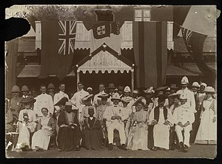
Sugra Visram, also known as Sugra Namubiru Visram, was a Ugandan politician, activist and businesswoman. She was one of the first female members of parliament co-opted into the Buganda Lukiiko by Kabaka Muteesa II. Affiliated to the Kabaka Yekka Party, she represented Kibuga Constituency in Uganda's First and Second Parliaments till she resigned as a member of parliament in 1966. Together with Florence Alice Lubega and Eseza Makumbi, she was one of the first three women to serve in this position in post-independence Uganda.
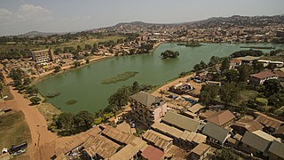
Kabaka's Lake is a man-made lake located in Kampala, the capital city of Uganda. It is one of the prominent landmarks in the city and holds great historical and cultural significance. It is the largest man-made lake in Uganda.
Twekobe aka Twekobe Palace is the official residence (building) for the Kabaka of Buganda and it is located with in the Lubiri. Its Wiki Loves Monuments ID: UG-C-048.


