Nakawa

Last updated
Nakawa
Location map Kampala.png
Red pog.svg
Nakawa
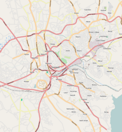
Map of Kampala showing the location of Nakawa.
Coordinates: 00°19′59″N32°37′05″E / 0.33306°N 32.61806°E / 0.33306; 32.61806
CountryFlag of Uganda.svg  Uganda
Region Central Uganda
District Kampala Capital City Authority
Division Nakawa Division
Time zone UTC+3 (EAT)

Nakawa is an area in the city of Kampala, Uganda's capital. It is also the location of the headquarters of Nakawa Division, one of the five administrative divisions of Kampala.

Contents

Location

Nakawa is located on the eastern edge of the city of Kampala. It is bordered by Ntinda to the north, Kyambogo to the northeast, Banda and Kireka to the est, Mbuya to the southeast, Bugoloobi to the south, Namuwongo to the southwest, Kololo in Kampala Central Division to the west, and Naguru to the northwest. The road distance between Kampala's central business district and Nakawa is approximately 5 kilometres (3.1 mi). [1] The coordinates of Nakawa are 0°19'59.0"N, 32°37'05.0"E (Latitude:0.333055; Longitude:32.618066). [2]

Overview

Nakawa lies on the main highway between Kampala and Jinja. From a mere intersection of the Kampala-Jinja Highway and Ntinda Road' in the 1950s, Nakawa has grown into a bustling metropolitan area with small, medium, and large industries and some of Uganda's highest institutions of learning. It is also home to Kampala Cemetery that contains 26 Commonwealth burials of the Second World War, the total made up of 19 soldiers of the East African Forces and seven men belonging to the Uganda Police. [3]

Landmarks

KampalaNakawaRoadCemetery-The Kampala (Nakawa Road) Cemetery in the Ugandan capital. The war graves plot contains 26 Commonwealth burials of WWII: 19 soldiers of the East African Forces and seven men belonging to the Uganda Police. One WWI casualty is commemorated by special memorial, and the Commonwealth War Graves Commission also cares for one Belgian war grave in the cemetery. KampalaNakawaRoadCemetery RomanDeckert26042024-01.jpg
KampalaNakawaRoadCemetery-The Kampala (Nakawa Road) Cemetery in the Ugandan capital. The war graves plot contains 26 Commonwealth burials of WWII: 19 soldiers of the East African Forces and seven men belonging to the Uganda Police. One WWI casualty is commemorated by special memorial, and the Commonwealth War Graves Commission also cares for one Belgian war grave in the cemetery.

Nakawa has the following landmarks:

Train bridge in Nakawa A man walks along the train tracks below a train bridge in Nakawa, Kampala.jpg
Train bridge in Nakawa

See also

Related Research Articles

Kyambogo is a neighborhood in Kampala, Uganda. It is within Nakawa Division, an administrative borough of Kampala, Uganda's capital city.

The Kampala–Jinja Highway is a road in Uganda, connecting the cities of Kampala and Jinja. Sometimes referred to as Kampala–Jinja Road, it is a busy road, with several towns, trading centers and other points of interest along the way. As of October 2016, a new, wider, four-lane dual carriageway expressway, the Kampala–Jinja Expressway, is proposed to be constructed south of the present highway to relieve traffic and complement existing transport infrastructure between Kampala and Jinja.

Nakawa Division is one of the five administrative divisions of the city of Kampala, the capital and largest city of Uganda. The town of Nakawa is the site of the division headquarters.

Mbuya is a hill in southeastern Kampala, the capital city of Uganda. The hill rises 1,300 metres (4,300 ft) above sea level. The name also applies to the upscale residential neighborhood that sits on that hill, as well as the government military installations located there.

Ntinda is a location in northeastern Kampala, the capital city of Uganda.

Naguru, also Naggulu, is a hill in Kampala, the capital and largest city in Uganda. The name also applies to the commercial and residential neighborhoods that sit on that hill.

Banda is a hill that lies in Nakawa Division, within Kampala, the capital of Uganda. Banda also refers to the neighborhoods on the slopes of the hill and between Banda Hill and Kireka, extending all the way to the Kampala-Jinja Highway. The southwestern slopes of the hill are occupied by the neighbourhood known as Kyambogo, and is the location of the campus of Kyambogo University, one of the nine public universities in the country.

Kisaasi is a location, within the city of Kampala, Uganda.

<span class="mw-page-title-main">Kiwaatule</span> Place in Central Region, Uganda

Kiwaatule is a township within the city of Kampala, Uganda's capital.

Kigoowa is a location within the city of Kampala, Uganda's capital.

FINCA Uganda Limited, also known as FINCA Uganda, is a microfinance deposit-accepting institution (MDI) in Uganda. It is licensed and regulated by the Bank of Uganda, the central bank and national banking regulator.

Naguru General Hospital, also known as China-Uganda Friendship Hospital Naguru, is a hospital in Uganda. It is an urban, general hospital built between 2009 and 2012, at an estimated cost of approximately US$8 million. The hospital was built by the Government of China, as a gift to the Government of Uganda.

Capital Shoppers Limited, commonly known as Capital Shoppers, is a Ugandan supermarket chain.

The Kampala–Bombo Expressway is a proposed four-lane, dual carriage highway in the Central Region of Uganda, connecting, Kampala, the capital city, and Bombo, in Luweero District.

Akright City is a residential community in Wakiso District of the Central Region of Uganda.

The JLOS House Project, is a three-component government office development project under construction in Uganda's capital city of Kampala. The buildings are intended to house the offices of the Justice, Law and Order Sector (JLOS). The three components of the project are:

The Nakawa–Naguru Estates is a mixed, urban, commercial and residential real estate development, under construction in Uganda.

Lugogo is an area in the city of Kampala, Uganda's capital.

Nakawa Vocational Training Institute (NVTI), is a public vocational training institute operated and administered by the Uganda Ministry of Education and Sports (MoES).

The Uganda Industrial Research Institute (UIRI) is a parastatal company, wholly owned by the government of Uganda, whose primary objective is to carry out scientific and industrial research, develop competitive technical services, improve the capacity and competence of indigenous entrepreneurs to embark on sustainable industrial production, to produce high quality marketable products, for the benefit of Uganda's citizens.

References

  1. GFC (3 February 2016). "Distance between Kampala Road, Kampala, Central Region, Uganda and Nakawa, Kampala, Central Region, Uganda". Globefeed.com (GFC). Retrieved 3 February 2016.
  2. Google (3 February 2016). "Location of Nakawa At Google Maps" (Map). Google Maps . Google. Retrieved 3 February 2016.
  3. CWGC. "Kampala (Nakawa Road) Cemetery | Cemetery Details". CWGC. Retrieved 2023-06-12.

00°19′46″N32°36′52″E / 0.32944°N 32.61444°E / 0.32944; 32.61444