Muyenga

Last updated
Muyenga
Location map Kampala.png
Red pog.svg
Muyenga
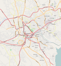
Map of Kampala showing the location of Muyenga.
Uganda location map.svg
Red pog.svg
Muyenga
Muyenga (Uganda)
Africa location map.svg
Red pog.svg
Muyenga
Muyenga (Africa)
Coordinates: 00°17′38″N32°36′41″E / 0.29389°N 32.61139°E / 0.29389; 32.61139
CountryFlag of Uganda.svg  Uganda
Region Central Uganda
District Kampala Capital City Authority
Division Makindye Division
Elevation
1,306 m (4,285 ft)
Time zone UTC+3 (EAT)

Muyenga is a hill in Kampala, the capital of Uganda and the largest city in that country. The name also applies to the upscale community that sits on that hill.

Contents

Location

Muyenga is located in Makindye Division, one of the five administrative divisions of Kampala. It sits about 8 kilometres (5.0 mi), by road, southeast of the central business district of the city. It is bordered by Bukasa to the east, Kiwuliriza to the north, Kisugu and Kabalagala to the west, Kansanga to the southwest, Kiwafu to the south and Kyeyitabya to the southeast. The coordinates of Muyenga Hill are:0°17'38.0"N, 32°36'41.0"E (Latitude:0.293900; Longitude:32.611400). [1]

Overview

Muyenga, at its peak, stands 4,285 feet (1,306 m) above sea level and is one of the highest points in the city of Kampala. For that reason, the hill was chosen to house the water storage tanks for National Water and Sewerage Corporation, which supply Kampala, Kira and Mukono. [2] Because of the water tanks, Muyenga is also known as Tank Hill. The hill commands expansive views of the city towards the north and the west. To the east and the south the predominant view is that of nearby Lake Victoria.

Prior to Uganda's Independence in 1962 and through the 1960s and 1970s, Muyenga was an upscale residential area, on account of the excellent views and cool breezes. After the removal of the Obote II regime in 1986, there followed a period of rapid, unplanned and uncoordinated development of the real estate on Muyenga. As a result, it is an area with good houses but with a chaotic road and drainage system. Many of the property owners on the hill are from government and business who bought plots and put up expensive buildings without conforming to the rules of urban planning. Kabalagala, a neighborhood to the west of Muyenga, suffered from the same mismanagement of urban planning. [3]

Points of interest

The following points of interest lie on Muyenga Hill or near it:

See also

Related Research Articles

Kololo is a hill in Kampala, the largest city and capital of Uganda. The name also applies to the upscale residential and commercial neighbourhood that sits on that hill.

<span class="mw-page-title-main">Makindye</span> Place in Central Uganda, Uganda

Makindye is a hill in Kampala, Uganda's largest city and capital. The name also refers to the neighborhood that sits on that hill. Makindye is also the seat of Makindye Division, one of the five administrative zones of the city of Kampala.

Ggaba is a neighborhood within the city of Kampala in the Central Region of Uganda.

<span class="mw-page-title-main">Nakasero</span> Neighborhood in Kampala city, Uganda

Nakasero is a hill and neighborhood in the centre of Kampala, the capital and largest city of Uganda. Nakasero is important to Uganda's economy and politics, as it is home to Kampala's central business district and several government offices, including the Ugandan Parliament Buildings.

<span class="mw-page-title-main">Munyonyo</span> Place in Central Region of Uganda, Uganda

Munyonyo is an area on the northern shores of Lake Victoria and part of the metropolitan area of Kampala, in Makindye Division.

Makindye Division is one of the five administrative divisions of Kampala, the capital of Uganda, and the largest city in that country. The city's five divisions are: (a) Kampala Central Division (b) Kawempe Division (c) Lubaga Division (d) Makindye Division and (e) Nakawa Division.

Namuwongo is a location in Kampala, the capital of Uganda and the largest city in that country.

Mbuya is a hill in southeastern Kampala, the capital city of Uganda. The hill rises 1,300 metres (4,300 ft) above sea level. The name also applies to the upscale residential neighborhood that sits on that hill, as well as the government military installations located there.

Kansanga is a neighborhood in Kampala, the capital and largest city of Uganda.

Naguru, also Naggulu, is a hill in Kampala, the capital and largest city in Uganda. The name also applies to the commercial and residential neighborhoods that sit on that hill.

Kibuli is a hill in the centre of Kampala, the capital and largest city in Uganda. The area is a suburb in the city centre and its name also applies to the commercial and residential neighbourhoods on that hill.

Bugoloobi sometimes spelled as Bugolobi, is a location in Kampala, Uganda's capital and largest city. It is a suburban neighborhood and some of the most valuable properties in Kampala are found here. It is among the most developed neighborhoods in Kampala and Uganda in general.

<span class="mw-page-title-main">Kikaaya</span> Place in Central Uganda, Uganda

Kikaaya is a neighborhood in the city of Kampala, Uganda's capital city. The correct phonetic spelling is with two 'a's, after the second 'k'.

<span class="mw-page-title-main">Kabalagala</span> Place in Central Uganda, Uganda

Kabalagala is a neighbourhood in Kampala, the capital and largest city in Uganda. It houses some of the leading partygoers in the city. It is located next to Nsambya where the American Embassy in Uganda is found.

Kiruddu General Hospital, also known as Kiruddu General Referral Hospital, is a hospital in Uganda. It is an urban, public, general hospital. It cost an estimated US$10.3 million plus about $350,000 in supervisory fees to build. The hospital was constructed by the government of Uganda, with funding from the African Development Bank (AfDB) and the Nigeria Trust Fund (NTF). The hospital opened to the public on 16 May 2016.

Institute of Petroleum Studies Kampala, IPSK, is a privately owned institution that offers training and instruction in the field of petroleum exploration, recovery, refinement and responsible utilization in Uganda.

Parombo is a town in the West Nile sub-region of the Northern Region of Uganda.

Katosi Water Works (KWW), also Katosi Water Treatment Plant is a water purification and distribution project in Uganda.

Mulawa is a neighborhood in Kira Municipality, Kyaddondo County, Wakiso District, in Central Uganda.

References

  1. "Location of Muyenga At Google Maps". Google Maps . Retrieved 20 June 2014.
  2. "Profile of Muyenga Hill". Uganda Travel Guide. Retrieved 20 June 2014.
  3. "Mr. President, Help Us Put Some Order In Kampala". New Vision. 17 May 2009. Archived from the original on 20 May 2009. Retrieved 20 June 2014.
  4. Kasozi, Ephraim; Weska, Anthony (12 February 2014). "Order Giving House To Katatumba Wrong - Court". Daily Monitor . Retrieved 20 June 2014.