Meyer Lansky, known as the "Mob's Accountant", was an American organized crime figure who, along with his associate Charles "Lucky" Luciano, was instrumental in the development of the National Crime Syndicate in the United States.

Mount Kisco is a village and town in Westchester County, New York, United States. The town of Mount Kisco is coterminous with the village. The population was 10,959 at the 2020 United States census.

Bedford Hills is a hamlet and census-designated place (CDP) in the town of Bedford, Westchester County, New York, United States. The population was 3,001 at the 2010 census. Two New York State prisons for women, Bedford Hills Correctional Facility for Women and Taconic Correctional Facility, are located in the hamlet.

Smith's Food and Drug, or simply Smith's, is an American regional supermarket chain that was founded by Lorenzo Smith in 1911 in Brigham City, Utah. Headquartered in Salt Lake City with stores in Utah, Nevada, New Mexico, Arizona, Montana, Idaho, and Wyoming, Smith's became a subsidiary of Kroger in 1998.

Meyer London was a Lithuanian-born American politician from New York City. He represented the Lower East Side of Manhattan and was one of only two members of the Socialist Party of America elected to the United States Congress.

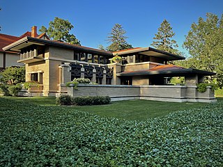
The Meyer May House is a Frank Lloyd Wright-designed house in the Heritage Hill Historic District of Grand Rapids, Michigan, in the United States. It was built in 1908–09, and is located at 450 Madison Avenue SE. It is considered a fine example of Wright's Prairie School era, and "Michigan's Prairie masterpiece".

Naylor Gardens is a small neighborhood located in southeast Washington, D.C. It is bounded by Alabama Avenue SE, Naylor Road SE, Good Hope Road SE, and Branch Avenue SE. The neighborhood is located in the area south and east of the Anacostia River.

Charles R. "Monk" Meyer was the runner-up for the Heisman Trophy in 1935, the first year the trophy was awarded, while playing for the United States Military Academy.

The Real Housewives of Beverly Hills is an American reality television series which has been broadcast on Bravo since October 14, 2010. Developed as the sixth installment of The Real Housewives franchise, it has aired thirteen seasons and focuses on the personal and professional lives of women who live in or near Beverly Hills, California.

Rum Hill is a mountain located in Central New York Region of New York northwest of the Hamlet of Pierstown. Red House Hill is located southeast, Metcalf Hill is located south, Allen Lake and Mohegan Hill are located north-northwest and Otsego Lake is located east of Rum Hill.
Red House Hill is a mountain in the Central New York Region of the State of New York, United States. It is located south-southwest of the Hamlet of Springfield Center, New York, west of Hutter Point and Six Mile Point of Otsego Lake, and southeast of Rum Hill. Mohican Brook flows eastward along the southern edge of the hill.
Fitch Hill is a mountain located in Central New York Region of New York by Pierstown. Fitch Hill is named after the Fitch family who were early settlers in the area.
Klock Hill is a mountain located in Central New York region of New York southwest of Burlington, New York.
Kilkenny Hill is a mountain in the Central New York region of New York, United States. It is located northwest of Unadilla, New York. Kilkenny Hill is part of the Northern Allegheny Plateau Ecoregion.
Calder Hill is a small mountain chain in the Central New York region of New York. It is located north of Otego, New York. It is made of two main peaks with the highest being 1841 feet.
Gifford Hill is a small mountain chain in the Central New York Region of New York. It is located northeast of Oneonta, New York. It is made of three main peaks the highest being 1928 feet. Gifford Hill is named for the Gifford Family who moved to the area in 1803 and settled along the Oneonta Creek on what is now called Gifford Hill.
Dairy Hill is a 1,844-foot-tall (562 m) summit located in Central New York Region of New York located in the Town of Norway in Herkimer County, southeast of Norway. The mountain is the former location of a 79-foot-6-inch-tall (24.23 m) steel fire lookout tower.
Red Hill is a mountain located in the Catskill Mountains of New York east-south of Frost Valley. Woodhull Mountain is located northeast of Red Hill.
Leonard Hill is a 2,592-foot-tall (790 m) mountain in Schoharie County, New York. It is located east-southeast of North Blenheim. Safford Hill is located northwest and Hubbard Hill is located southeast of Leonard Hill. In 1948, the Conservation Commission built an 80-foot-tall (24 m) steel fire lookout tower on the mountain. The tower ceased fire watching operations at the end of the 1988 season and was officially closed in early 1989. The tower remains on the summit, but is closed to the public. A local group is planning to restore the tower and reopen it to the public.
Cord MeyerII was an American businessman and politician from New York.


