Mitchell Square Park

Last updated
The World War I Memorial in the park. WSTM Equipe C'est N'est Pas Une Pipe 0082.jpg
The World War I Memorial in the park.

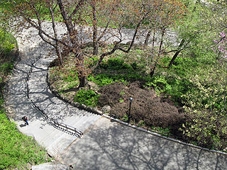
Mitchel Square Park is a small urban park in the Washington Heights neighborhood of the New York City borough of Manhattan. It is a two part, triangle shaped park formed by the intersection of Saint Nicholas Avenue, Broadway and 167th Street.

Washington Heights, Manhattan Neighborhood of Manhattan in New York City

Washington Heights is a neighborhood in the northern portion of the New York City borough of Manhattan. The area, with over 150,000 inhabitants as of 2010, is named for Fort Washington, a fortification constructed at the highest point on the island of Manhattan by Continental Army troops during the American Revolutionary War, to defend the area from the British forces. Washington Heights is bordered by Harlem to the south, along 155th Street, Inwood to the north along Dyckman Street or Hillside Avenue, the Hudson River to the west, and the Harlem River and Coogan's Bluff to the east.

New York City Largest city in the United States

The City of New York, usually called either New York City (NYC) or simply New York (NY), is the most populous city in the United States. With an estimated 2017 population of 8,622,698 distributed over a land area of about 302.6 square miles (784 km2), New York is also the most densely populated major city in the United States. Located at the southern tip of the state of New York, the city is the center of the New York metropolitan area, the largest metropolitan area in the world by urban landmass and one of the world's most populous megacities, with an estimated 20,320,876 people in its 2017 Metropolitan Statistical Area and 23,876,155 residents in its Combined Statistical Area. A global power city, New York City has been described as the cultural, financial, and media capital of the world, and exerts a significant impact upon commerce, entertainment, research, technology, education, politics, tourism, art, fashion, and sports. The city's fast pace has inspired the term New York minute. Home to the headquarters of the United Nations, New York is an important center for international diplomacy.

Manhattan Borough in New York City and county in New York, United States

Manhattan, often referred to locally as the City, is the most densely populated of the five boroughs of New York City and its economic and administrative center, cultural identifier, and historical birthplace. The borough is coextensive with New York County, one of the original counties of the U.S. state of New York. The borough consists mostly of Manhattan Island, bounded by the Hudson, East, and Harlem rivers; several small adjacent islands; and Marble Hill, a small neighborhood now on the U.S. mainland, physically connected to the Bronx and separated from the rest of Manhattan by the Harlem River. Manhattan Island is divided into three informally bounded components, each aligned with the borough's long axis: Lower, Midtown, and Upper Manhattan.

The southern part of the park, enclosed by an iron fence, is a grassy area with benches and large outcroppings of Manhattan schist.

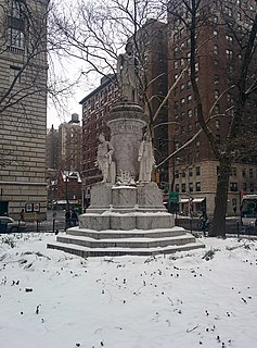
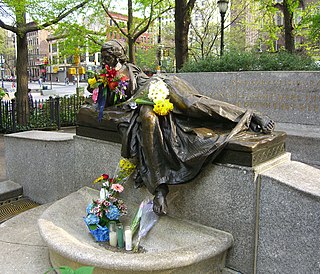
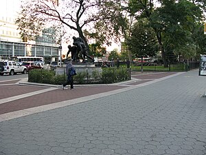
The northern part features a World War I Memorial in the form of a sculpture by Gertrude Vanderbilt Whitney. [1] There are three bronze figures, a wounded sailor is supported by a Marine, while an army private bends to talk to the wounded man. This monument received a 1923 medal from the New York Society of Architects as "the most meritorious monument erected during the year." [2] The figural group is mounted on a granite pedestal that reads: “Erected by the people of Washington Heights and Inwood in commemoration of the men who gave their lives in the World War.” When it was erected, on Memorial Day, May 1922, there had been only one world war. The sculpture is surrounded by a fence and plantings.

World War I 1914–1918 global war originating in Europe

World War I, also known as the First World War or the Great War, was a global war originating in Europe that lasted from 28 July 1914 to 11 November 1918. Contemporaneously described as "the war to end all wars", it led to the mobilisation of more than 70 million military personnel, including 60 million Europeans, making it one of the largest wars in history. It is also one of the deadliest conflicts in history, with an estimated nine million combatants and seven million civilian deaths as a direct result of the war, while resulting genocides and the 1918 influenza pandemic caused another 50 to 100 million deaths worldwide.

Gertrude Vanderbilt Whitney American sculptor

Gertrude Vanderbilt Whitney was an American sculptor, art patron and collector, and founder in 1931 of the Whitney Museum of American Art in New York City. She was a prominent social figure and hostess, who was born into the wealthy Vanderbilt family and married into the Whitney family.

The park was previously named Audubon Square. [3]

Related Research Articles

Morningside Park (New York City) park in New York City

Morningside Park is a public park in the Morningside Heights neighborhood of Manhattan, New York City. The 30-acre (12 ha) area occupies 110th to 123rd Streets from Morningside Avenue to Morningside Drive at the border between Harlem and Morningside Heights. Much of the park is adjacent to Columbia University. Morningside Park's natural geography contains a cliff of Manhattan schist rock, with manmade features in the park such as an ornamental pond and waterfall. It is operated by New York City Department of Parks and Recreation. The park was first proposed by the Central Park Commissioners in 1867, and the city commissioned Frederick Law Olmsted and Calvert Vaux to produce a design for the park in 1873. Jacob Wrey Mould was hired in 1880 to rework the plans, although he died in 1886 before the work could be completed. In 1887, Olmsted and Vaux were asked to modify the plans again, and construction was completed in 1895.

Upper Manhattan neighborhood in New York City

Upper Manhattan is the most northern region of the New York City Borough of Manhattan. Its southern boundary has been variously defined, but 96th Street, the northern boundary of Central Park at 110th Street, 125th Street or 155th Street are some common usages.

Bennett Park (New York City) park in New York City

Bennett Park, also known as James Gordon Bennett Park, is a public park in New York City, named for James Gordon Bennett, Sr., the newspaper publisher who launched the New York Herald in 1835. It is located between Pinehurst and Fort Washington Avenues and West 183rd and 185th Streets in the Hudson Heights neighborhood of Washington Heights in northern Manhattan, on land purchased by Bennett in 1871, the year before his death. It sits opposite the northern Fort Washington Avenue entrance to the 181st Street subway station on the IND Eighth Avenue Line, serviced by the A train.

Washington Square Arch triumphal arch in Washington Square Park in Manhattan, New York City

The Washington Square Arch is a marble triumphal arch built in 1892 in Washington Square Park in the Greenwich Village neighborhood of Lower Manhattan in New York City. It celebrates the centennial of George Washington's inauguration as President of the United States in 1789 and forms the grand southern terminus of Fifth Avenue.

Madison Square and Madison Square Park square and park in Manhattan, New York City

Madison Square is a public square formed by the intersection of Fifth Avenue and Broadway at 23rd Street in the New York City borough of Manhattan. The square was named for James Madison, fourth President of the United States. The focus of the square is Madison Square Park, a 6.2-acre (2.5-hectare) public park, which is bounded on the east by Madison Avenue ; on the south by 23rd Street; on the north by 26th Street; and on the west by Fifth Avenue and Broadway as they cross.

Soldiers and Sailors Monument (Manhattan)

The Soldiers' and Sailors' Memorial Monument located at 89th Street and Riverside Drive in Riverside Park in the Upper West Side of Manhattan, New York City, commemorates Union Army soldiers and sailors who served in the American Civil War. It is an enlarged version of the Choragic Monument of Lysicrates in Athens, and was designed by the firm of Stoughton & Stoughton with Paul E. M. DuBoy. The monument was completed in 1902.

4th Street (Manhattan) Street in New York City

4th Street is a street in Lower Manhattan, New York City. It starts at Avenue D as East 4th Street and continues to Broadway, where it becomes West 4th Street. It continues west until the Avenue of the Americas, where West 4th Street turns north and confusingly intersects with West 10th, 11th, 12th, and 13th Streets in Greenwich Village. Most of the street has the same 40-foot (12 m) width between curbstones as others in the prevailing street grid, striped as two curbside lanes and one traffic lane, with one-way traffic eastbound. The portion from Seventh to Eighth Avenues is westbound and is approximately 35 feet (11 m) wide, a legacy of the original Greenwich Village street grid. The section of four short blocks from MacDougal Street to University Place which forms the southern border of Washington Square Park is called Washington Square South.

Vanderbilt Avenue is the name of three thoroughfares in the New York City boroughs of Brooklyn, Manhattan, and Staten Island. They were named after Cornelius Vanderbilt (1794–1877), the builder of Grand Central Terminal in Midtown Manhattan.

Dante Park Park in New York City

Dante Park is a public park in Manhattan, New York City, located in the Upper West Side neighborhood in front of Lincoln Center near Central Park.

<i>Titanic</i> Memorial (Washington, D.C.) artwork by Gertrude Vanderbilt Whitney and John Horrigan

The TitanicMemorial is a granite statue in southwest Washington, D.C., that honors the men who gave their lives so that women and children might be saved during the RMS Titanic disaster. The thirteen-foot-tall figure is of a partly clad male figure with arms outstretched standing on a square base. The base is flanked by a square exedra, created by Henry Bacon, that encloses a small raised platform. The statue was erected by the Women's Titanic Memorial Association.

Stuyvesant Square neighborhood in New York City

Stuyvesant Square is the name of both a park and its surrounding neighborhood in the New York City borough of Manhattan. The park is located between 15th Street, 17th Street, Rutherford Place, and Nathan D. Perlman Place. Second Avenue divides the park into two halves, east and west, and each half is surrounded by the original cast-iron fence.

New York Studio School of Drawing, Painting and Sculpture non-profit organisation in the USA

The New York Studio School of Drawing, Painting and Sculpture at 8 West 8th Street, in Greenwich Village, Manhattan, New York City, New York State is an art school formed in 1963 by a group of students and their teacher, Mercedes Matter, all of whom had become disenchanted with the fragmented nature of art instruction inside traditional art programs and universities. Today it occupies the building that previously housed the Whitney Museum of American Art.

Verdi Square

Verdi Square is a small triangle of land enclosed by a railing, located on Manhattan's Upper West Side, between 72nd Street and 73rd Street on the south and north, and Broadway and Amsterdam Avenue on the west and east. On the south the square fronts West 72nd Street; across the street to the south lies Sherman Square. On the north side, the park is enclosed by the Florentine Renaissance palazzo of the Central Savings Bank, now Apple Bank for Savings; that trapezoidal structure, with a vast vaulted Roman banking hall 65 feet high, was designed by York and Sawyer and built in 1926–28.

Whitney Museum of American Art (original building) building in Manhattan, New York, United States

The Whitney Museum of American Art original building is a collection of three 1838 rowhouses located at 8-12 West 8th Street between Fifth Avenue and MacDougal Street in the Greenwich Village neighborhood of Manhattan, New York City. In 1907, Gertrude Vanderbilt Whitney established the Whitney Studio Gallery at 8 West 8th Street adjacent to her own MacDougal Alley studio. This, and the later Whitney Studio Club at 147 West 4th Street, were intended to provide young artists with places to meet and exhibit their works.

155th Street (Manhattan) street in Manhattan

155th Street are two crosstown streets in the Harlem and Washington Heights neighborhood, in the New York City borough of Manhattan. They serve as the border between Harlem and Washington Heights neighborhoods of Manhattan. They are the northernmost of the 155 crosstown streets mapped out in the Commissioner's Plan of 1811 that established the numbered street grid in Manhattan. The street consists of a "high portion" which is a major artery through the area, as well as a lesser-used "low portion".

Straus Park

Straus Park is a small landscaped park on the Upper West Side of Manhattan, at the intersection of Broadway, West End Avenue, and 106th Street.

Jackson Square Park (Manhattan)

Jackson Square Park is an urban park in the Greenwich Village Historic District in Manhattan, New York City, United States. The 0.227 acres (920 m2) park is bordered by 8th Avenue on the west, Horatio Street on the south, and Greenwich Avenue on the east. The park interrupts West 13th Street.

Thomas Paine Monument

The Thomas Paine Monument is a bronze sculpture located in New Rochelle, New York, dedicated to perpetuating the legacy of Founding Father Thomas Paine. The monument stands on North Avenue at the entrance to Paine Avenue, between the Thomas Paine National Historical Association to the north and the property of the Huguenot and Historical Association of New Rochelle to the south. This is the oldest extant memorial to Thomas Paine. The original monument erected in 1839 consisted of just a tapered marble pedestal and decorative cap. A bronze bust of Paine was later added in 1899.

References

  1. Dunlap, David W. "A Medical Center Works on Its Health", The New York Times , October 4, 1998. Accessed July 15, 2008.
  2. WHITNEY, Gertrude Vanderbilt (1875-1942) -- American sculptor and art patron, Ancestry.com. Accessed July 15, 2008.
  3. "A" Streets of New York, NYC Streets. Accessed July 15, 2008.

Coordinates: 40°50′24.5″N73°56′24″W / 40.840139°N 73.94000°W / 40.840139; -73.94000

Geographic coordinate system Coordinate system

A geographic coordinate system is a coordinate system that enables every location on Earth to be specified by a set of numbers, letters or symbols. The coordinates are often chosen such that one of the numbers represents a vertical position and two or three of the numbers represent a horizontal position; alternatively, a geographic position may be expressed in a combined three-dimensional Cartesian vector. A common choice of coordinates is latitude, longitude and elevation. To specify a location on a plane requires a map projection.