Fort Washington Park (New York City)

Last updated
Fort Washington Park

Jeffrey's Hook Lighthouse 18.JPG

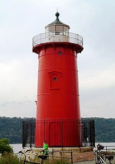
Fort Washington Park view of the Little Red Lighthouse and George Washington Bridge
Location Along the Hudson River from W. 155 Street to Dyckman Street.
Coordinates 40°50′58″N73°56′48″W / 40.84944°N 73.94667°W / 40.84944; -73.94667 Coordinates: 40°50′58″N73°56′48″W / 40.84944°N 73.94667°W / 40.84944; -73.94667
Area 160 acres (65 ha)
Operated by NYC Parks
Website http://www.nycgovparks.org/parks/fort-washington-park

Fort Washington Park is located in the Washington Heights section of Upper Manhattan, New York City, along the banks of the Hudson River next to Riverside Drive from West 155th Street to Dyckman Street. The George Washington Bridge crosses above the park, and below the bridge is the small point of land also called Jeffrey's Hook, [1] which is the site of the Little Red Lighthouse.

Washington Heights, Manhattan Neighborhood of Manhattan in New York City

Washington Heights is a neighborhood in the northern portion of the New York City borough of Manhattan. The area, with over 150,000 inhabitants as of 2010, is named for Fort Washington, a fortification constructed at the highest point on the island of Manhattan by Continental Army troops during the American Revolutionary War, to defend the area from the British forces. Washington Heights is bordered by Harlem to the south, along 155th Street, Inwood to the north along Dyckman Street or Hillside Avenue, the Hudson River to the west, and the Harlem River and Coogan's Bluff to the east.

Upper Manhattan neighborhood in New York City

Upper Manhattan denotes the most northern region of the New York City Borough of Manhattan. Its southern boundary has been variously defined, but 96th Street, the northern boundary of Central Park at 110th Street, 125th Street or 155th Street are some common usages.

Manhattan Borough in New York City and county in New York, United States

Manhattan, often referred to locally as the City, is the most densely populated of the five boroughs of New York City and its economic and administrative center, cultural identifier, and historical birthplace. The borough is coextensive with New York County, one of the original counties of the U.S. state of New York. The borough consists mostly of Manhattan Island, bounded by the Hudson, East, and Harlem rivers; several small adjacent islands; and Marble Hill, a small neighborhood now on the U.S. mainland, physically connected to the Bronx and separated from the rest of Manhattan by the Harlem River. Manhattan Island is divided into three informally bounded components, each aligned with the borough's long axis: Lower, Midtown, and Upper Manhattan.

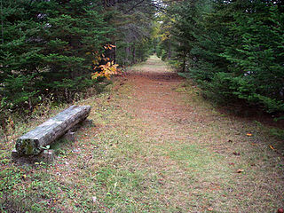
The 160-acre park features river-side views of the New Jersey Palisades and the George Washington Bridge. Amenities include pedestrian and greenway paths, baseball fields, basketball courts, tennis courts, volleyball courts, a soccer field and a playground.

Greenway (landscape) long piece of land, where vegetation and slow travel are encouraged

A greenway is "a strip of undeveloped land near an urban area, set aside for recreational use or environmental protection". However, the term can in fact include "a scenic road" and though many are in urban areas, there are some rural greenways, as for example the Monadnock-Sunapee Greenway, a hiking trail in southern New Hampshire.

The park references the nearby site of Fort Washington, a fortified position that was the site of the 1776 Battle of Fort Washington during the American Revolutionary War. The fort's actual location is located and commemorated in Bennett Park.

Fort Washington (Manhattan) former fort in Manhattan

Fort Washington was a fortified position near the north end of Manhattan Island, at the island's highest point, within the modern-day neighborhood of Washington Heights, Manhattan, New York City. The Fort Washington Site is listed on the U.S. National Register of Historic Places.

Battle of Fort Washington battle

The Battle of Fort Washington was a battle fought in New York on November 16, 1776 during the American Revolutionary War between the United States and Great Britain. It was a British victory that gained the surrender of the remnant of the garrison of Fort Washington near the north end of Manhattan Island. It was one of the worst Patriot defeats of the war.

American Revolutionary War War between Great Britain and the Thirteen Colonies, which won independence as the United States of America

The American Revolutionary War (1775–1783), also known as the American War of Independence, was an 18th-century war between Great Britain and its Thirteen Colonies which declared independence as the United States of America.

Related Research Articles

George Washington Bridge Suspension bridge crossing the Hudson River between Fort Lee, New Jersey and Manhattan, New York

The George Washington Bridge is a double-decked suspension bridge spanning the Hudson River, connecting the Washington Heights neighborhood of Manhattan in New York City with the borough of Fort Lee in New Jersey. As of 2016, the George Washington Bridge carried over 103 million vehicles per year, making it the world's busiest motor vehicle bridge. It is owned by the Port Authority of New York and New Jersey, a bi-state government agency that operates infrastructure in the Port of New York and New Jersey. The George Washington Bridge is also informally known as the GW Bridge, the GWB, the GW, or the George, and was known as the Fort Lee Bridge or Hudson River Bridge during construction.

Fort Erie, Ontario Town in Ontario, Canada

Fort Erie is a town on the Niagara River in the Niagara Region, Ontario, Canada. It is directly across the river from Buffalo, New York and is the site of Old Fort Erie which played a prominent role in the War of 1812.

Sandy Hook peninsula in New Jersey

Sandy Hook is a barrier spit in Middletown Township, Monmouth County, New Jersey, United States. The barrier spit, approximately 6 miles (9.7 km) in length and varying from 0.1 to 1.0 mile wide, is located at the north end of the Jersey Shore. It encloses the southern entrance of Lower New York Bay south of New York City, protecting it from the open waters of the Atlantic Ocean to the east. The Dutch called the area "Sant Hoek", with the English "Hook" deriving from the Dutch "Hoek", meaning "spit of land".

Little Red Lighthouse lighthouse in New York, United States

The Little Red Lighthouse, officially Jeffrey's Hook Light, is a small lighthouse located in Fort Washington Park along the Hudson River in Manhattan, New York City, under the George Washington Bridge. It was made notable by the 1942 children's book The Little Red Lighthouse and the Great Gray Bridge by Hildegarde Swift, illustrated by Lynd Ward. The lighthouse stands on Jeffrey's Hook, a small point of land that supports the base of the eastern pier of the bridge, which connects Washington Heights, Manhattan, to Fort Lee, New Jersey.

Red Hook, Brooklyn Neighborhood of Brooklyn in New York City

Red Hook is a neighborhood in the New York City borough of Brooklyn, New York. It is located on a peninsula projecting into the Upper New York Bay and is bounded by the Gowanus Expressway and the Carroll Gardens neighborhood on the northeast, Gowanus Canal on the east, and the Upper New York Bay on the west and south. A prosperous shipping and port area in the early 20th century, the area declined in the latter part of the century.

Downtown Pittsburgh Neighborhood of Pittsburgh in Allegheny County, Pennsylvania, United States

Downtown Pittsburgh, colloquially referred to as the Golden Triangle, and officially the Central Business District, is the urban downtown center of Pittsburgh. It is located at the confluence of the Allegheny River and the Monongahela River whose joining forms the Ohio River. The "triangle" is bounded by the two rivers. The area features offices for major corporations such as PNC Bank, U.S. Steel, PPG, Bank of New York Mellon, Heinz, Federated Investors and Alcoa. It is where the fortunes of such industrial barons as Andrew Carnegie, Henry Clay Frick, Henry J. Heinz, Andrew Mellon and George Westinghouse were made. It contains the site where the French fort, Fort Duquesne, once stood.

Sandy Hook Light lighthouse in New Jersey, United States

The Sandy Hook Lighthouse, located about one and a half statute miles (2.4 km) inland from the tip of Sandy Hook, New Jersey, is the oldest working lighthouse in the United States. It was designed and built on June 11, 1764 by Isaac Conro. At that time, it stood only 500 feet from the tip of Sandy Hook; however, today, due to growth caused by littoral drift, it is almost one and a half miles (2.4 km) inland from the tip.

Magnolia, Seattle Seattle Neighborhood

Magnolia is the second largest neighborhood of Seattle, Washington by area. It occupies a hilly peninsula northwest of downtown. Magnolia has been a part of the city since 1891. A good portion of the peninsula is taken up by Discovery Park, formerly the U.S. Army's Fort Lawton.

Paulus Hook, Jersey City neighborhood of Jersey City, New Jersey

Paulus Hook is a community on the Hudson River waterfront in Jersey City, New Jersey, located one mile across the river from Manhattan. The name Hook comes from the Dutch word "hoeck" which translates into "point of land." This "point of land" has been described as an elevated area, the location of which is today bounded by Montgomery, Hudson, Dudley and Van Vorst Streets. The neighborhood's main street is the north- and south-running Washington Street. The waterfront of Paulus Hook is along the basin of the Morris Canal in a park with a segment of Liberty State Park. The Hudson-Bergen Light Rail has a Paulus Hook stop at Essex Street and the Liberty Water Taxi at Warren Street. The introduction of the light rail and development of office buildings on the Hudson Waterfront have brought more businesses to Morris Street including a number of restaurants with outdoor seating and small neighborhood shops.

Hooks Mills, West Virginia Unincorporated community in West Virginia, United States

Hooks Mills is an unincorporated community in Hampshire County, West Virginia, United States. It is located on Hooks Mill Road which intersects Cacapon River Road 4.5 miles south of Capon Bridge. Hooks Mills is named for the saw and grist mill on the Cacapon River run by the Hook family from 1848 to the late 1930s.

Cape Disappointment State Park state park of Washington, United States

Cape Disappointment State Park is a public recreation area located southwest of Ilwaco, Washington, on the bottom end of Long Beach Peninsula, the northern headlands where the Columbia River meets the Pacific Ocean. The state park's 2,023 acres (819 ha) encompass a diverse landscape of old-growth forest, freshwater lakes, freshwater and saltwater marshes, and oceanside tidelands. Park sights include the Lewis and Clark Interpretive Center, North Head Lighthouse, and Cape Disappointment Lighthouse. Cape Disappointment is one of several state parks and sites in Washington and Oregon that make up the Lewis and Clark National and State Historical Parks.

Fort Lee Historic Park

Fort Lee Historic Park is located atop a bluff of the Hudson Palisades overlooking Burdett's Landing, known as Mount Constitution, in Fort Lee, New Jersey. Native Americans appear to have lived in the area for thousands of years before the arrival of Europeans. Site of George Washington's 1776 encampment opposite Fort Washington at the northern end of Manhattan. Fort Lee is named for General Charles Lee. The site is a reconstruction of the encampment including the blockhouse, battery, quarters as well as a visitors center. It is part of Palisades Interstate Park.

Raritan Bayshore

The Raritan Bayshore region of New Jersey is a subregion of the larger Jersey Shore. It is the area around Raritan Bay from The Amboys to Sandy Hook, in Monmouth and Middlesex counties, including the towns of Perth Amboy, Keyport, "Pearl of the Bayshore", Keansburg, and Highlands, New Jersey. It is the northernmost part of the Jersey Shore, located just south of New York City. At Keansburg is a traditional amusement park while at Sandy Hook are found ocean beaches. The Sadowski Parkway beach area in Perth Amboy, which lies at the mouth of the Raritan River, was deemed the "Riviera of New Jersey" by local government. In the last years many of the beaches on the Bayshore area have been rediscovered and upgraded as the quality of the water continues to improve.

Fairlawn (Washington, D.C.)

Fairlawn is a working class and middle class residential neighborhood located in southeast Washington, D.C. It is bounded by Interstate 295, Pennsylvania Avenue SE, Minnesota Avenue SE, Naylor Road SE, and Good Hope Road SE.

Hudson River Waterfront Walkway

The Hudson River Waterfront Walkway, also known as the Hudson River Walkway, is an ongoing and incomplete project located on Kill van Kull and the western shore of Upper New York Bay and the Hudson River, implemented as part of a New Jersey state-mandated master plan to connect the municipalities from the Bayonne Bridge to the George Washington Bridge with an urban linear park and provide contiguous unhindered access to the water's edge.

Anacostia Historic District

The Anacostia Historic District is a historic district in the city of Washington, D.C., comprising approximately 20 squares and about 550 buildings built between 1854 and 1930. The Anacostia Historic District was added to the National Register of Historic Places in 1978. "The architectural character of the Anacostia area is unique in Washington. Nowhere else in the District of Columbia does there exist such a collection of late-19th and early-20th century small-scale frame and brick working-class housing."

References

  1. "Jeffrey's Hook, NY". Lighthouse Friends. Retrieved 25 August 2014.