
Mumbai is the capital city of the Indian state of Maharashtra. According to the United Nations, as of 2018, Mumbai is the second-most populous city in India after Delhi and the eighth-most populous city in the world with a population of roughly 2 crore. As per the Indian government population census of 2011, Mumbai was the most populous city in India with an estimated city proper population of 1.25 crore (12.5 million) living under the Municipal Corporation of Greater Mumbai. Mumbai is the centre of the Mumbai Metropolitan Region, the sixth most populous metropolitan area in the world with a population of over 2.3 crore. Mumbai lies on the Konkan coast on the west coast of India and has a deep natural harbour. In 2008, Mumbai was named an alpha world city. It has the highest number of millionaires and billionaires among all cities in India. Mumbai is home to three UNESCO World Heritage Sites: the Elephanta Caves, Chhatrapati Shivaji Maharaj Terminus, and the city's distinctive ensemble of Victorian and Art Deco buildings designed in the 19th and 20th centuries.
The Godavari is India's second longest river after the Ganga and third largest in India, drains about 10% of India's total geographical area. Its source is in Trimbakeshwar, Nashik, Maharashtra. It flows east for 1,465 kilometres (910 mi), draining the states of Maharashtra (48.6%), Telangana (18.8%), Andhra Pradesh (4.5%), Chhattisgarh (10.9%) and Odisha (5.7%). The river ultimately empties into the Bay of Bengal through an extensive network of tributaries. Measuring up to 312,812 km2 (120,777 sq mi), it forms one of the largest river basins in the Indian subcontinent, with only the Ganga and Indus rivers having a larger drainage basin. In terms of length, catchment area and discharge, the Godavari is the largest in peninsular India, and had been dubbed as the Dakshina Ganga.
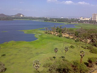
Powai Lake is an artificial lake, situated in Mumbai, in the Powai valley, where a Powai village with a cluster of huts existed. The city suburb called Powai shares its name with the lake. Indian Institute of Technology Bombay, one of the premier institutions of science and technology in India, is located to the east of the lake. Another famous institution, the National Institute of Industrial Engineering (NITIE), is also located close to the lake. Housing complexes and plush hotels are developed all around the lake periphery. Population around the lake has thus substantially increased over the years.

Thane district is a district in the Indian state of Maharashtra in Konkan Division. At the 2011 Census it was the most populated district in the country, with 11,060,148 inhabitants; however, in August 2014 the district was split into two with the creation of a new Palghar district, leaving the reduced Thane district with a 2011 Census population of 8,070,032. The headquarters of the district is the city of Thane. Other major cities in the district are Navi Mumbai, Kalyan-Dombivli, Mira-Bhayander, Bhiwandi, Ulhasnagar, Ambarnath, Badlapur, Murbad and Shahapur.

Salsette Island is an island in Konkan division of the state of Maharashtra on India's west coast. Administratively known as the Greater Mumbai, the city district of Mumbai, Mumbai Suburban District, Mira Bhayander and a portion of Thane lie within it, making it very populous and one of the most densely populated islands in the world. It has a population of more 20 million inhabitants living on an area of about 619 square kilometres (239 sq mi).
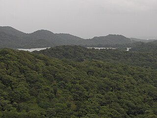
Tulsi Lake is a fresh water lake in northern Mumbai. It is stated to be the second largest lake in Mumbai and supplies part of the city's potable water. This is one of the three lakes located in the Salsette Island; the other two being Powai Lake and Vihar Lake. Both Tulsi lake and Vihar lake are located within the densely forested Sanjay Gandhi National Park or also known popularly as the Borivali National Park (BNP).

Vihar Lake is located near Vihar village on the Mithi River within the precincts of the Borivali National Park, also called the Sanjay Gandhi National Park, in North Mumbai. When built in 1860, it was considered as the largest lake in Mumbai in the Salsette group of islands. It is hemmed between the Tulsi Lake and the Powai Lake(shown in map). It partly meets the drinking water needs of the Mumbai region. It supplies only 3% of the Mumbai city's water requirement, after filtration at Bhandup where the large water filtration plant is located. .
Mumbai controls several dams in Shahpur taluk that deliver water to the city. The Western Ghats trap most of the moisture laden monsoon clouds which feed these dammed rivers. Currently, these dams deliver approximately 3.4 billion litres of water to Mumbai daily. Here are the dams supplying the city the water it needs to survive:

The Daman Ganga also called Dawan River is a river in western India. The river's headwaters are on the western slope of the Western Ghats range, and it flows west into the Arabian Sea. The river flows through Maharashtra and Gujarat states, as well as the Union territory of Dadra and Nagar Haveli and Daman and Diu. The industrial towns of Vapi, Dadra and Silvassa lie on the north bank of the river, and the town of Daman occupies both banks of the river's estuary.

The Vaitarna River is a river in Nashik and Palghar district of Maharashtra. The Tansa is its left bank tributary and the Pinjal, Dehraja, and Surya are its right bank tributaries. Upper stretches of the Vaitarna are clean but in lower stretches it is polluted due to untreated industrial and civic waste. The Vaitarna is one of the most polluted rivers in India.

The Mithi River is a river on Salsette Island, the island of the city of Mumbai, India. It is a confluence of tail-water discharges of the Powai and Vihar lakes. The river is seasonal and rises during the monsoons. The overflowing lakes also contribute to the river flow, which is stopped by a dam at other times. During this season, the gutter is a favourite with anglers, who can catch large fish that have escaped from the lakes. Chattrapati Shivaji Maharaj International Airport is located right next to the section of river at Andheri (E).

The word Maharashtra, the land of the Marathi-speaking people, appears to be derived from Maharashtri, an old form of Prakrit. Some believe that the word indicates that it was the land of the Mahars and the Rattas, while others consider it to be a corruption of the term 'Maha Kantara', a synonym for 'Dandakaranya'. Maharashtra is the third largest state in India after Rajasthan and Madhya Pradesh. It covers an area of 307,713 km2 and is bordered by the states of Madhya Pradesh to the north, Chhattisgarh to the east, Telangana to the southeast, Karnataka to the south and Goa to the southwest. The state of Gujarat lies to the northwest, with the Union territory of Dadra and Nagar Haveli sandwiched between the borders. Maharashtra has coastline of 720 km.The Arabian Sea makes up Maharashtra's west coast. Maharashtra consists of two major relief divisions. The plateau is a part of the Deccan tableland and the Konkan coastal strip abutting on the Arabian Sea.
Middle Vaitarna Dam is a dam in Maharashtra, India. It is the third tallest dam in the state at 84 metres (276 ft) and is made of roller compacted concrete.
Vasai-Virar is a Municipal Corporation that governs the Four areas i.e. Naigaon, Vasai, Nallasopara & Virar in Konkan division of Maharashtra, India.

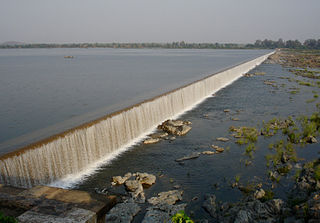
Tansa dam, is an earthfill and gravity dam on Tansa river near Mumbai, Thane district in the state of Maharashtra in India. The dam is one of the seven sources of drinking water to the city of Mumbai.

Vaitarna Dam, also called Modaksagar Dam, is a Gravity dams on Vaitarna river which supplies water to Palghar, Mumbai, but located in Palghar & Nashik district in the state of Maharashtra in India. It was opened in 1957.
Upper Vaitarana Dam, is an earthfill and gravity dam on west flowing Vaitarna river near Igatpuri, Nashik district of Maharashtra state in India. The reservoir created by this dam spreads on both Vaitarna and Godavari rivers catchment area.

The Manmad Junction Railway Station is a Central Railway junction in India, serving the town of Manmad in the Nashik district of Maharashtra. It is one of the Central Railways' major stations, connecting Nashik with many major cities in the region, including Mumbai and Pune. Around 51 trains travel between the Mumbai and Manmad railway stations every week.
Palghar District is a district in the state of Maharashtra in Konkan Division. On 1 Aug 2014, the Maharashtra state government announced the formation of the 36th district of Maharashtra Palghar, it was partitioned out of the old Thana district (Trombay) which was formed in British India. Palghar District starts from Dahanu at the north and ends at Naigaon. It comprises the talukas of Palghar, Vada, Vikramgad, Jawhar, Mokhada, Dahanu, Talasari and Vasai-Virar. At the 2011 Census, the talukas now comprising the district had a population of 2,990,116.
The Tansa Wildlife Sanctuary is located in Shahapur and Bhiwandi taluka of Thane district and Wada taluka of Palghar district. The sanctuary is spread over an area of 320 square km. This sanctuary is spread around the catchment area of Tansa, Vaitarna and Modak Sagar lakes which are major source of water to the Mumbai, Thane and Bhiwandi cities. There are about 60 villages in the sanctuary area. The forest area is hilly with dense patches of forest.


