
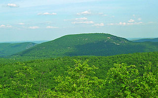
Storm King Mountain is a mountain on the west bank of the Hudson River just south of Cornwall-on-Hudson, New York. Together with Breakneck Ridge on the opposite bank of the river it forms "Wey-Gat" or Wind Gate, the picturesque northern narrows of the Hudson Highlands. Its distinctive curved ridge is the most prominent aspect of the view south down Newburgh Bay, from Newburgh, Beacon, and the Newburgh-Beacon Bridge. It can also be seen by southbound travelers on nearby sections of the New York State Thruway. This view was a popular subject for early artists of the Hudson River School.

The Hudson Highlands are mountains on both sides of the Hudson River in New York state lying primarily in Putnam County on its east bank and Orange County on its west. They continue somewhat to the south in Westchester County and Rockland County, respectively. The highlands are a subrange of the Appalachian Mountains.
Bear Mountain is one of the best-known peaks of New York's Hudson Highlands. Located partially in Orange County in the town of Highlands and partially in Rockland County in the town of Stony Point, it lends its name to the nearby Bear Mountain Bridge and Bear Mountain State Park that contains it.

New York State Route 418 (NY 418) is a 3.50-mile (5.63 km) state highway located entirely within the Adirondack Park in Warren County, New York, in the United States. The route begins just west of the hamlet of Thurman Station, where Athol Road changes designations from County Route 4 (CR 4) to NY 418. It heads eastward through the towns of Thurman and Warrensburg, following the Schroon River to an intersection with U.S. Route 9 (US 9) in the hamlet of Warrensburg. All of NY 418 is part of the Dude Ranch Trail, a New York State Scenic Byway that runs through Warren County and Saratoga County.
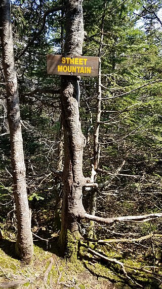
Street Mountain is a mountain located in Essex County, New York, named after Alfred Billings Street (1811–1881), a poet and New York State Librarian. The mountain is the high point of the Street Range of the Adirondack Mountains. Street's northeast ridge is Nye Mountain.
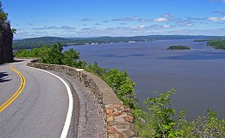
The Storm King Highway is a three-mile (4.8 km) segment of New York State Route 218 (NY 218) between Lee Road in the Town of Highlands at the south end and the Cornwall-on-Hudson village line in Orange County, New York, in the United States. It was built in 1916 and added to the National Register of Historic Places in 1982 in recognition of its accomplishment in civil engineering.

Blackhead is a mountain located in Greene County, New York.

Plateau Mountain is located in the town of Hunter in Greene County, New York, United States. It is part of the Devil's Path range of the Catskill Mountains. Plateau has a two-mile-long (3.2 km) summit ridge above 3,500 feet (1,100 m). The highest point, at least 3,840 feet (1,170 m), is at the southeast end, facing Sugarloaf Mountain to the east across Mink Hollow Notch. It is the 12th-highest peak in the range Devils Tombstone is located west of Plateau Mountain. The northwest end faces Hunter Mountain to the west across 1,400-foot deep (430 m) Stony Clove Notch.

Berlin Mountain is a 2,818-foot-tall (859 m) prominent peak in the Taconic Mountains of western New England and is located adjacent to Massachusetts's border with New York State. It is the highest point in Rensselaer County. The summit and west side of the mountain are located in New York; the east side lies within Williamstown, Massachusetts. The mountain is a bald, notable for its grassy summit and expansive views of the Hudson River Valley to the west. The 37-mile (60 km) Taconic Crest Trail traverses the mountain. Several other hiking trails approach the summit from the east. Much of the upper slopes and summit are within protected conservation land. Historically the lower slopes of the mountain were farmed heavily throughout the 19th Century. In addition to agriculture, there are several remnants of charcoal kilns located on the mountain that produced fuel for iron smelting.
Ashokan High Point or High Point is a 3,081 feet (939 m) summit in the Catskill Mountains of New York. High Point is the loftiest part of a massif that includes the adjacent Mombaccus Mountain, Little Rocky and South Mountain. The summit can be accessed via the Kanape Brook Trail, which ascends from Ulster County Road 42 to the saddle between High Point and Mombaccus. This trail, named for 19th-century farmer John Canape, was formerly a wagon track connected to the present-day Freeman Avery Road on the south side of the mountain, providing a route between Watson Hollow and Samsonville in the days of the Catskills tanneries. The Gazetteer and Business Directory of Ulster County, N. Y. For 1871-2 referred to the peak as "Shokan Point". It was also known as "Samson," after the Catskill tannery owner for whom Samsonville was named, and is so identified on a 1942 United States Coast and Geodetic Survey benchmark at the summit. Nowadays, Samson Mountain is the name given to a nearby peak above the upper reaches of Rondout Creek.

Sugarloaf Mountain is a 900-foot (270 m) peak located in the town of Fishkill near the Hudson River and Breakneck Ridge. One of several similarly named mountains in the U.S. state of New York, it is part of the Hudson Highlands, located entirely within Hudson Highlands State Park.

Hook Mountain State Park is a 676-acre (2.74 km2) undeveloped state park located in Rockland County, New York. The park includes a portion of the Hudson River Palisades on the western shore of the Hudson River, and is part of the Palisades Interstate Park system. Hook Mountain State Park is functionally part of a continuous complex of parks that also includes Rockland Lake State Park, Nyack Beach State Park, and Haverstraw Beach State Park.
Red House Hill is a mountain in the Central New York Region of the State of New York, United States. It is located south-southwest of the Hamlet of Springfield Center, New York, west of Hutter Point and Six Mile Point of Otsego Lake, and southeast of Rum Hill. Mohican Brook flows eastward along the southern edge of the hill.
Klock Hill is a mountain located in Central New York region of New York southwest of Burlington, New York.
Virgil Mountain is a mountain in the central part of the state of New York. It is located east-southeast of Virgil in Cortland County. It is the highest point in Cortland County and is ranked 28 of 62 on the list of New York county high points.
Frost Hill is a mountain in the Finger Lakes Region of New York. It is located west of Bristol Springs in Ontario County. At an elevation of 2,284 feet (696 m), the mountain is the highest point in Ontario County. It is about 1.25 miles (2.01 km) southwest of the 2,150-foot (660 m) Worden Hill, where Bristol Mountain Ski Resort is.

Huntersfield Mountain is a mountain located in the Catskill Mountains of New York north-northwest of Ashland. Ashland Pinnacle is located east, and Tower Mountain is located south-southeast of Huntersfield Mountain. It is the highest point in Schoharie County and it is ranked 9 of 62 on the list of New York County High Points.
Chapin Hill is a 1,427-foot-tall (435 m) mountain in the state of New York. It is located southwest of Monticello in Sullivan County. In 1924, a 60-foot-tall (18 m) steel fire lookout tower was built on the mountain. Due to increased use of aerial fire detection, the tower closed at the end of the 1970 fire season, and was later removed.

