Montague, Prince Edward Island

Last updated
Montague
Montague PEI.jpg
Montague marina and skyline
Montauge PEI flag.gif
Montauge PEI crest.png
Montague, Prince Edward Island logo.png
Motto: 
Prosper Fair Montague
Canada Prince Edward Island location map 2.svg
Red pog.svg
Montague
Location of Montague in PEI
Coordinates: 46°10′11″N62°39′14″W / 46.16979°N 62.65383°W / 46.16979; -62.65383
CountryCanada
Province Prince Edward Island
County Kings County
Founded1732
Incorporated April 26, 1917
AmalgamatedSeptember 28, 2018
Area
  City3.16 km2 (1.22 sq mi)
Elevation
28 m (92 ft)
Population
 (2021) [1]
  City2,027
  Density620.8/km2 (1,608/sq mi)
   Metro
6,011
  Change (2011-16)
Increase2.svg 3.4%
Time zone UTC−4 (Atlantic (AST))
  Summer (DST) UTC−3 (ADT)
Postal code
C0A 1R0
Area code 902
Telephone Exchange 313 326 361 784 838 846 969
NTS Map011L02
GNBC CodeBABTL
Website Official website

Montague is a community within the Town of Three Rivers in Kings County, Prince Edward Island, Canada. Previously incorporated as a town, it amalgamated with the Town of Georgetown, the rural municipalities of Brudenell, Cardigan, Lorne Valley, Lower Montague, and Valleyfield, and portions of three adjacent unincorporated areas in 2018.

Contents

Montague is the largest population centre in the county and straddles the Montague River which is the dividing line between the townships of Lot 52 and Lot 59. The community functions as a regional service centre for the eastern end of the province, supporting two supermarkets, three hardware stores, a number of independent businesses, and several fast food restaurants, banks, and car dealerships.

General information

Montague is home to the Kings County Memorial Hospital, provincial government offices, and the Montague Curling Club, along with an elementary, intermediate and regional high school. A number of older homes and commercial buildings have been replaced with new, suburban style development along Main Street, particularly in the north end. A large scale redevelopment of the community's waterfront has taken place in recent years.

The community is located 44 km east of Charlottetown and 15 km southwest of Georgetown.

History

In 1732, Jean-Pierre Roma, an Acadian French merchant, settled a site a few miles east of present-day Montague that he called Trois Rivieres, now The Three Rivers. It is now a designated historic site, which brings to life his story and how he established there an international trading post. Its interpretive centre is open from the last week of June to the last week of September each year. [2] Unfortunately for him and his business, the French Army on Ile St. Jean were to be defeated by the British in 1745, in an act of ethnic cleansing in which the Acadian population was deported and lost all their earthly goods.

At the time of Samuel Holland's survey in the 1760s, Georgetown was designated as the shire town of Kings County. The Montague River was the southernmost of three rivers draining the area. Eventually Lower Montague, Montague Road and Montague Bridge were named after the river. The river itself traces its name to either George Brudenell, 4th Earl of Cardigan (later George Montagu, 1st Duke of Montagu), John Montagu, 4th Earl of Sandwich, or Montague Wilmot, Governor of Nova Scotia (which then included St. John's Island - present-day Prince Edward Island) at the time of Holland's survey.

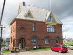
The Garden of the Gulf Museum (c. 1887 to 1888) is on the Canadian Register of Historic Places. [3]

Recent events

Montague waterfront MontagurPEWaterfront.jpg
Montague waterfront

Montague is notable as the first community to combine a Wendy's restaurant and a Tim Hortons franchise under one roof. In 1992, the owner of both franchises in Prince Edward Island, Daniel P. Murphy, opened a new outlet for both brands in the same building in the community. He invited Ron Joyce and Wendy's chairman Dave Thomas to the grand opening, where the two executives met for the first time and established an immediate rapport. Murphy's success with the combined operation led to an agreement resulting in a merger of Wendy's and Tim Hortons (TDL Group) in 1995. [4]

Montague has had several modest property developments in recent decades, consisting of several subdivisions, as well as new big box retail and institutional buildings.

The bridge carrying Route 4 across the Montague River was replaced in December 2007.

The Cavendish Farms Wellness Centre opened in 2009 on the southern edge of the community beside the existing Atlantic Fitness Centre East complex. This facility includes an Olympic sized hockey arena, municipal offices, meeting rooms, two indoor walking tracks and the local library. [5]

In early 2010, the provincial Department of Fisheries, Aquaculture and Rural Development relocated from Charlottetown to a new building in downtown Montague.

Montague Regional High School opened for the 2010–2011 school year at the southern edge of the community on Valleyfield Road. [6]

In 2011, the intersection of the Wood Islands Rd (Route 4) and the Valleyfield Rd (Route 326) was replaced by Kings County's first roundabout.

In 2014, the 30-room Riverhouse Inn hotel opened, [7] and Aspin Kemp & Associates' world headquarters relocated to Montague, along with the relocation of a construction facility for the marine supply company to nearby Poole's Corner. [8]

The same year, Montague also received $320,000 of federal and provincial funding for cultural development, which was used in the construction of a waterfront art gallery, park construction, and the installation of several historic murals throughout the community. [9]

In July 2016, the Montague local council elicited controversy when it voted 2-4 against a request to fly the pride flag during pride month. [10]

On September 28, 2018, the Town of Montague amalgamated with the Town of Georgetown, five nearby rural municipalities – Brudenell, Cardigan, Lorne Valley, Lower Montague, and Valleyfield, and portions of three adjacent unincorporated areas to form the Town of Three Rivers. [11]

Demographics

Federal census population history of Montague
YearPop.±%
1921 706    
1931 803+13.7%
1941 769−4.2%
1951 1,068+38.9%
19561,152+7.9%
19611,126−2.3%
19661,289+14.5%
19711,608+24.7%
19761,827+13.6%
19811,957+7.1%
19861,994+1.9%
1991 1,901−4.7%
1996 1,995+4.9%
2001 1,945−2.5%
2006 1,802−7.4%
2011 1,895+5.2%
2016 1,961+3.5%
2021 2,027+3.4%
Source: Statistics Canada
[12] [13] [14] [15] [16] [17] [18] [19] [20] [21] [22] [23]

Government

As of September 28, 2018, Montague is governed by the Town of Three Rivers. [11] The Kings District of the Royal Canadian Mounted Police (RCMP) serve the community from their headquarters just north of Montague, with one officer exclusively serving the community.

Culture

Montague celebrates its birthday the first week after Canada day every year with an annual tradition called Montague Days, with activities including midway, buskers, soap box derby, Miss Montague contest, a pet parade,a parade (missed in 2007 due to construction of the bridge) and a fireworks display on the Montague Waterfront to wrap up the weekend long festival. The Montague Waterfront also plays host to musical acts and various other activities all weekend long. The gazebo at the waterfront was constructed by local carpenter, Shane Phillip MacDonald. He described it as his magnum opus. [24]

Education

Montague is home to three English Language School Board schools: [25]

The provincial community college, Holland College, has a location in the Down East Mall, in a wing named the "Montague Centre." [26]

Sports

Montague is home to several sports teams and recreation programs. It has running tracks, recreational trails, parks, and playing fields for soccer, rugby, football, field hockey, softball and baseball. The community also has a swimming pool and fitness centre along with basketball courts and nearby tennis courts. The Eastern Eagles Soccer Complex, on the southern edge of the community, is home to the regional soccer teams, the Eastern Eagles. The Eastern Eagles host a soccer tournament for other teams on Prince Edward Island and those from out of province every summer. In 2009, the Cavendish Farms Wellness Centre opened, giving a new home to the Montague Norsemen hockey teams and replacing the aging Iceland Arena. It also gave Montague junior B and senior hockey teams, the Montague Maniacs and Montague Marines. The community is also home to the Montague Curling Club, which takes in curlers from all of Kings County. [27] Montague Regional High School and Montague Intermediate School are also home to many male and female sports teams.

Climate

Montague has a humid continental climate (Dfb) with short, warm summers with cool nights and long, cold, and wet winters.

Climate data for Montague
MonthJanFebMarAprMayJunJulAugSepOctNovDecYear
Record high °C (°F)11.8
(53.2)
12.5
(54.5)
22.6
(72.7)
23.3
(73.9)
32
(90)
33.2
(91.8)
36.3
(97.3)
33.9
(93.0)
32.7
(90.9)
24.4
(75.9)
21.2
(70.2)
15.6
(60.1)
36.3
(97.3)
Mean daily maximum °C (°F)−3.4
(25.9)
−3
(27)
1.2
(34.2)
6.7
(44.1)
14
(57)
19.6
(67.3)
23.6
(74.5)
22.9
(73.2)
18
(64)
11.9
(53.4)
5.6
(42.1)
−0.3
(31.5)
9.7
(49.5)
Mean daily minimum °C (°F)−12.3
(9.9)
−11.7
(10.9)
−6.8
(19.8)
−1.1
(30.0)
4.7
(40.5)
10.2
(50.4)
14.5
(58.1)
14.2
(57.6)
9.8
(49.6)
4.4
(39.9)
−0.9
(30.4)
−8
(18)
1.4
(34.5)
Record low °C (°F)−29.9
(−21.8)
−26.1
(−15.0)
−23.9
(−11.0)
−13.4
(7.9)
−5
(23)
0
(32)
6.7
(44.1)
4.4
(39.9)
−0.1
(31.8)
−5.6
(21.9)
−13.3
(8.1)
−25.6
(−14.1)
−29.9
(−21.8)
Average precipitation mm (inches)100.1
(3.94)
75.1
(2.96)
83.8
(3.30)
79.7
(3.14)
94
(3.7)
84.4
(3.32)
84.8
(3.34)
88.3
(3.48)
91.7
(3.61)
94.5
(3.72)
96.7
(3.81)
105
(4.1)
1,078
(42.4)
Source: Environment Canada [28]

Attractions

Garden of the Gulf Museum Garden of the Gulf.jpg
Garden of the Gulf Museum

Montague's main attraction is the community itself, aptly named "Montague the Beautiful" for its tree-lined streets, tranquil river and stately buildings. Other draws include the Garden of the Gulf Museum (the oldest museum in the province), the Canada Tree, the Montague Curling Club, Cavendish Farms Wellness Centre, Montague Regional High School, the Down East Mall, Station Street Adventure Company, [29] and Gillis' Drive-In Restaurant (in Brudenell). Montague is also a starting point of the Confederation Trail, linking many communities across P.E.I. The former train station has been renovated into a café, gift shop and information centre, looking out over the river.

Economy

Like much of the province, the area's three main industries are fishing, farming and tourism. Montague is home to many independent businesses, along with several chains primarily in the North End. Several large employers include the new Department of Fisheries, Aquaculture and Rural Development, the Provincial Addictions Centre, Vital Statistics, On-Line Support, Shoppers Drug Mart, Mariner Seafoods, Cavendish Farms potato processing plant in Pooles Corner, Real Atlantic Superstore, and Sobeys. The community itself has no designated industrial areas, however neighbouring communities, notably Pooles Corner, have several industrial businesses.

Montague has a public wharf located in Lower Montague on the South shore of the Montague River at Wightmans Point Road. [30]

The region's weekly newspaper, the Eastern Graphic, is based in Montague.

Fishing boats in Montague Harbor 2021-08-23 Montague Harbor, Prince Edwards Island, Canada.jpg
Fishing boats in Montague Harbor

Neighbourhoods

Aerial view of Montague Aerial-view-of-Montague.jpg
Aerial view of Montague

"Greater Montague," which includes outlying areas outside the actual community, has a population of over 6,000. It comprises several neighbourhoods, including:

Notable people

Related Research Articles

<span class="mw-page-title-main">Stratford, Prince Edward Island</span> Town in Prince Edward Island, Canada

Stratford is a town located in Queens County, Prince Edward Island.

<span class="mw-page-title-main">Summerside, Prince Edward Island</span> City in Prince Edward Island, Canada

Summerside is a Canadian city in Prince County, Prince Edward Island. It is the second largest city in the province and the primary service centre for the western part of the island.

<span class="mw-page-title-main">Kings County, Prince Edward Island</span> County

Kings County is located in eastern Prince Edward Island, Canada.

<span class="mw-page-title-main">Cornwall, Prince Edward Island</span> Town in Prince Edward Island, Canada

Cornwall is a Canadian town located in Queens County, Prince Edward Island. The town is located immediately west of the provincial capital Charlottetown.

<span class="mw-page-title-main">Souris, Prince Edward Island</span> Town in Prince Edward Island, Canada

Souris is a town in Kings County, Prince Edward Island, Canada. It is located near the northeastern tip of the province.

<span class="mw-page-title-main">North Rustico</span> Town in Prince Edward Island, Canada

North Rustico is a Canadian town located in Queens County, Prince Edward Island.

Alberton is a Canadian town located in Prince County, Prince Edward Island. It is situated in the western part of the county in the township of Lot 5.

<span class="mw-page-title-main">Georgetown, Prince Edward Island</span> Place in Prince Edward Island, Canada

Georgetown is a community located within the municipality of Three Rivers in Kings County, Prince Edward Island, Canada. It is the Capital of Kings County. Previously incorporated as a town, it amalgamated with the town of Montague, the rural municipalities of Brudenell, Cardigan, Lorne Valley, Lower Montague, and Valleyfield, and portions of three adjacent unincorporated areas in 2018.

Breadalbane is a municipality that holds community status in Prince Edward Island, Canada. Located in Queens County, Prince Edward Island, its population as of 2021 is 170.

<span class="mw-page-title-main">Murray Harbour</span> Community in Prince Edward Island, Canada

Murray Harbour is a community that holds rural municipality status in Prince Edward Island, Canada. It is located in southeastern Kings County.

Mount Stewart is a rural municipality in Prince Edward Island, Canada. It is located in the northeastern part of Queens County, at the head of the once-navigable portion of the Hillsborough River at the point where the river begins to narrow significantly. Mount Stewart had a population of 226 at the time of the 2021 Census.

Victoria is a rural municipality in Prince Edward Island, Canada. A historic seaport, the community is situated at the extreme southwestern edge of Queens County in the township of Lot 29.

St. Louis is a municipality that holds community status in Prince Edward Island, Canada.

<span class="mw-page-title-main">Charlottetown</span> Capital city of Prince Edward Island, Canada

Charlottetown is the capital and largest city of the Canadian province of Prince Edward Island, and the county seat of Queens County. Named after Queen Charlotte, Charlottetown was an unincorporated town until it was incorporated as a city in 1855.

<span class="mw-page-title-main">Cardigan, Prince Edward Island</span> Municipality in Prince Edward Island

Cardigan was a municipality that held community status in Prince Edward Island, Canada. It was a fishing community in eastern Kings County.

<span class="mw-page-title-main">Clyde River, Prince Edward Island</span> Rural municipality in Prince Edward Island, Canada

Clyde River is a rural municipality in Prince Edward Island, Canada. Clyde River is located in Queens County in the central part of Prince Edward Island and just 15 minutes away from Charlottetown. The original community name was Dog River. It was named after the River Clyde in Scotland. Heritage is predominantly Scottish and English.

<span class="mw-page-title-main">Resort Municipality, Prince Edward Island</span> Resort municipality in Prince Edward Island, Canada

Resort Municipality, officially named the Resort Municipality of Stanley Bridge, Hope River, Bayview, Cavendish and North Rustico, is the lone municipality in Prince Edward Island, Canada that holds resort municipality status. It was established in 1990.

<span class="mw-page-title-main">Three Rivers, Prince Edward Island</span> Town in Prince Edward Island, Canada

Three Rivers is a town within Kings County in Prince Edward Island that was incorporated on September 28, 2018, through an amalgamation of seven municipalities and adjacent unincorporated areas. The municipalities that were amalgamated included two towns – Georgetown and Montague – and five rural municipalities – Brudenell, Cardigan, Lorne Valley, Lower Montague, and Valleyfield.

References

  1. "Census Profile, 2021 Census: Montague, Town [Dissolved Census subdivision], Prince Edward Island". Statistics Canada. Retrieved January 14, 2024.
  2. "Roma at Three Rivers ... heritage, history & culture come alive". www.roma3rivers.com.
  3. "Garden of the Gulf Museum". Canada's Historic Places. Parks Canada. Retrieved October 12, 2019.
  4. "US burger giant buys Tim Hortons doughnut chain". CBC.ca Archives. CBC News. August 8, 1995. Archived from the original on March 5, 2008.
  5. "Montague Wellness". The Town of Montague. Archived from the original on October 16, 2008.
  6. Armstrong, Nigel (July 10, 2007). "New school for Montague wins unanimous support". The Guardian. Archived from the original on March 5, 2016.
  7. Sharratt, Steve (February 9, 2014). "Down by the Riverhouse". The Guardian. Archived from the original on March 28, 2014.
  8. Sharratt, Steve (March 7, 2014). "Aspin Kemp and Associates moving headquarters to P.E.I." The Guardian. Archived from the original on March 28, 2014.
  9. Sharratt, Steve (March 22, 2014). "Montague gets $320,000 in funding for cultural development". The Guardian. Archived from the original on March 28, 2014.
  10. "Montague rejects Pride flag again". CBC PEI. July 26, 2016. Retrieved April 13, 2021.
  11. 1 2 "EC2018586: Municipal Government Act Town of Three Rivers Establishment" (PDF). Government of Prince Edward Island Executive Council. September 25, 2018. pp. 323–327. Retrieved October 27, 2018.
  12. "Table 6: Population by census subdivisions, 1901–1961". 1961 Census of Canada (PDF). Series 1.1: Historical, 1901–1961. Vol. I: Population. Ottawa: Dominion Bureau of Statistics. March 8, 1963. Retrieved February 2, 2022.
  13. "Table 2: Population of Census Subdivisions, 1921–1971". 1971 Census of Canada (PDF). Population. Vol. Census Subdivisions (Historical). Ottawa: Statistics Canada. July 1973. Retrieved February 2, 2022.
  14. "1976 Census of Canada: Population - Geographic Distributions" (PDF). Statistics Canada. June 1977. Retrieved February 2, 2022.
  15. "1981 Census of Canada: Census subdivisions in decreasing population order" (PDF). Statistics Canada. May 1992. Retrieved February 2, 2021.
  16. "1986 Census: Population - Census Divisions and Census Subdivisions" (PDF). Statistics Canada. September 1987. Retrieved February 2, 2022.
  17. "91 Census: Census Divisions and Census Subdivisions - Population and Dwelling Counts" (PDF). Statistics Canada. April 1992. Retrieved February 2, 2022.
  18. "96 Census: A National Overview - Population and Dwelling Counts" (PDF). Statistics Canada. April 1997. Retrieved February 2, 2022.
  19. "Population and Dwelling Counts, for Canada, Provinces and Territories, and Census Subdivisions (Municipalities), 2001 and 1996 Censuses - 100% Data (Prince Edward Island)". Statistics Canada. August 15, 2012. Retrieved February 2, 2022.
  20. "Population and dwelling counts, for Canada, provinces and territories, and census subdivisions (municipalities), 2006 and 2001 censuses - 100% data (Prince Edward Island)". Statistics Canada. August 20, 2021. Retrieved February 2, 2022.
  21. "Population and dwelling counts, for Canada, provinces and territories, and census subdivisions (municipalities), 2011 and 2006 censuses (Prince Edward Island)". Statistics Canada. July 25, 2021. Retrieved February 2, 2022.
  22. "Population and dwelling counts, for Canada, provinces and territories, and census subdivisions (municipalities), 2016 and 2011 censuses – 100% data (Prince Edward Island)". Statistics Canada. February 8, 2017. Retrieved February 2, 2022.
  23. "2021 Census of the former Town of Montague". Statistics Canada. 2023. Retrieved January 14, 2014.
  24. Sharratt, Steve (May 21, 2014). "New stage takes shape for Montague waterfront events". The Guardian. Archived from the original on March 4, 2016.
  25. "Public Schools". Government of Prince Edward Island - Public Schools Branch. Retrieved October 12, 2019.
  26. "Campuses and Centres". Holland College. Retrieved October 12, 2019.
  27. "Montague Curling Rink" . Retrieved October 12, 2019.
  28. Environment Canada Canadian Climate Normals 1971–2000. Retrieved July 15, 2009.
  29. "Station Street Adventure Company" . Retrieved August 24, 2018.
  30. Canada, Province of Prince Edward Island. "Island Information". www.gov.pe.ca.

Further reading