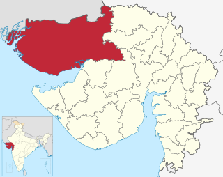
Kutch district, officially spelled Kachchh, is a district of Gujarat state in western India, with its headquarters (capital) at Bhuj. Covering an area of 45,674 km2, it is the largest district of India. The area of Kutch is larger than the entire area of other Indian states like Haryana (44,212 km2) and Kerala (38,863 km2), as well as the country of Estonia (45,335 km2). The population of Kutch is about 2,092,371. It has 10 talukas, 939 villages and 6 municipalities. The Kutch district is home to the Kutchi people who speak the Kutchi language.

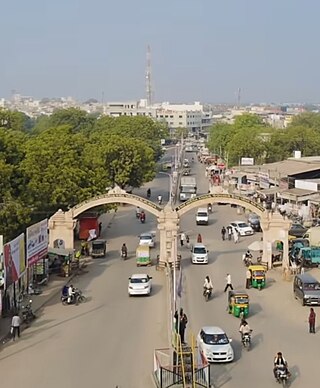
Bhuj is a city and the headquarters of Kutch district in the Indian state of Gujarat.

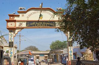
Anjar is a town, township and municipality of the Kachchh district (Kutch)in the state of Gujarat, India. Founded in 650 AD, Anjar is a culturally diverse town of historic importance in the region. It is home to several historic religious temples, including the Jesal-Toral Shrines built in honour of a fourteenth century couple, whose lives inspired works of art and cinema. The town was devastated by several earthquakes, including the 1819 Rann of Kutch earthquake and 2001 Gujarat earthquake. In recent years, Anjar has become a hub of manufacturing activity.

Khedbrahma is a town and a taluka headquarter in Khedbrahma Taluka of Sabarkantha district, Gujarat, India. It is situated on the banks of Harnav river. The town is connected with mythological history and has been pilgrim site for centuries. The 11th century Brahma, Ambika and Pankhnath Mahadev temples are the oldest monuments of the town. The town has an old stepwell, the Brahma Vav. It was under Parmaras, Chaulukyas and Pariharas before it came under Idar State in 13th century.
Tharad is a Taluka of Banaskantha district in Gujarat in India. It is the administrative center of Tharad taluka. Here is 134 villages. Tharad is 45km near to international boarder with Pakistan and 40km to national boarder with Rajasthan. main industries are agriculture and private businesses. It is one of the first major towns in Gujarat on National Highway 68.
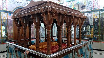
Maharajadhiraj Mirza Maharao Sir Khengarji III Sawai Bahadur was a progressive and one of the longest ruling monarchs and also the longest ruling king of the Princely State of Kutch from 1875 to 1942.
Bhadresar or Bhadreshwar is a village in Mundra Taluka, Kutch district of Gujarat, India. It is about 27 km from Taluka headquarters Mundra and barely a kilometer away from the seashore.

Koteshwar is a small village and the location of an ancient Shiva temple. It located near the mouth of Kori Creek, in the west of Kutch district of Gujarat, India.
Alfred High School in Bhuj, Kutch is one of the oldest educational institution of Gujarat and first high school of Kutch. It was founded by Rao of Cutch, Pragmalji II in year 1870 at cost of ₹150,000 (US$1,800). The school was named Alfred High School, after Prince Alfred, the Duke of Edinburgh.
Kothara is a village and a Jain pilgrimage center located in Abdasa Taluka of Kutch district of Gujarat, India.
Bhuvad is a village of Ahir [Zaru] And Rathod or rathore Rajput Kshatriya in Anjar Taluka of Kutch district of Gujarat, India.
The Gandhidham–Palanpur section belongs to the Western Railway of Kutch district of Gujarat state.

Bhadreshwar Jain Temple, also known as Vasai Jain Temple, is a historical importance located in Bhadreshwar village of Mundra Taluka, Kutch, Gujarat, India.
Gedi is a village near Rapar of Kutch district of Gujarat, India.

Kera is a village in Bhuj Taluka of Kutch district of Gujarat, India.this historical town was ruled by the jadeja's before independence in 1947. This historical town has several places of interest; the most important part of the town's history the Darbar gadh, the ruins of an old fort and Shiva temple, and the shrine of a Muslim saint Ghulam Ali.
Sikra is a village in Bhachau Taluka of Kutch district of Gujarat, India.
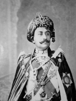
Rao Godji II, was the Rao of Cutch belonging to Jadeja Rajput dynasty, who ascended the throne of Princely State of Cutch in 1760 and ruled until 1778 when he died. During his rein, the state was invaded by Kalhoras and Talpuras of Sindh several times.
The history of Kutch, (kachchh) a region in the extreme west of the western Indian state of Gujarat, can be traced back to prehistorical times. There are several sites related to Indus valley civilization in region and is mentioned in Hindu mythology. In historical times, Kutch is mentioned in Greek writings during Alexander. It was ruled by Menander I of Greco-Bactrian Kingdom which was overthrown by Indo-Scythians followed by Maurya Empire and Sakas. in the first century, it was under Western Satraps followed by Gupta Empire. By fifth century, Maitraka of Valabhi took over from which its close association with ruling clans of Gujarat started. Chavdas ruled the eastern and central parts by seventh century but then came under Chaulukyas by tenth century. After fall of Chaulukya, Vaghelas ruled the state. Following conquest of Sindh by Muslim rulers, Rajput Samma started moving southwards to Kutch and ruled western regions initially. By tenth century, they controlled significant area of Kutch and by thirteenth century they controlled whole of Kutch and adopted a new dynastic identity, Jadeja.

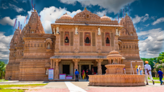
The Shantinath Jain temple is located in Kothara village of Kutch district, Gujarat, India. The temple is dedicated to the 16th Tirthankara Shantinatha and is an important place of pilgrimage for the followers of Jainism.
Jairam Shivji was an Indian merchant and banker from Kutch, India, who operated from Zanzibar and Muscat. Having almost monopolized the entire Zanzibar market, he was the wealthiest person in East Africa during his career there.