
New Taipei City is a special municipality located in northern Taiwan. The city is home to an estimated population of 4,004,367 as of January 2023, making it the most populous city in Taiwan, and also the second largest special municipality by area, behind Kaohsiung. The top-level administrative divisions bordering New Taipei City are Keelung to the northeast, Yilan County to the southeast, and Taoyuan to the southwest, and it completely encloses the city of Taipei. Banqiao District is its municipal seat and biggest commercial area.

Pratas Island, also known as the Tungsha Islands or the Dongsha Islands, is a coral island situated in the northern part of the South China Sea administered as part of Cijin District, Kaohsiung, Taiwan. It is located about 170 nautical miles southeast of Hong Kong. It has an area of about 240 hectares, including 64 hectares of lagoon, and is the largest of the South China Sea Islands. It is the location of the Dongsha Airport.

Taroko National Park is one of the nine national parks in Taiwan and was named after the Taroko Gorge, the landmark gorge of the park carved by the Liwu River. The park spans Taichung Municipality, Nantou County, and Hualien County and is located in Xiulin Township, Hualien County, Taiwan.

Chiayi County is a county in Taiwan. Located in southwestern Taiwan surrounding but not including Chiayi City, it is the sixth largest county in the island of Taiwan. Its major tourist destination is Alishan National Scenic Area.
Kenting National Park, commonly known as Kenting, is a national park located on the Hengchun Peninsula of Pingtung County, Taiwan, covering Hengchun, Checheng, and Manzhou Townships. Established on 1 January 1984, it is Taiwan's oldest and the southernmost national park on the main island, covering the southernmost area of the Taiwan island along Bashi Channel. Administered by the National Park Service of the Ministry of the Interior, this national park is well known for its tropical climate and sunshine, scenic mountain and beach, the Spring Scream rock-band festival held in every March, and has long been one of the most popular tourist destinations in Taiwan with 5.84 million visitors in 2016.

Yushan National Park is one of the nine national parks in Taiwan and was named after the summit Yushan, the highest peak of the park. The park covers a total area of 103,121 hectares that includes large sections of the Central Mountain Range. The park contains more than thirty peaks over 3,000 metres (9,843 ft) in elevation, and two-thirds of the area within the park is above 2,000 metres (6,562 ft). The elevation difference in the park is 3,600 metres (11,811 ft), and there are many canyons, cliffs, and valleys.

The Kinmen National Park is a national park in Kinmen, Fuchien Province, Republic of China.

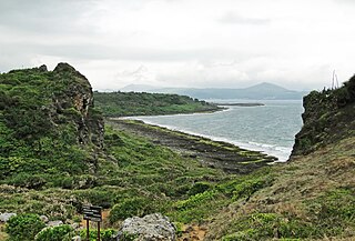
Cape Eluanbi or Oluanpi, also known by other names, is the southernmost point on the island of Taiwan. It is located in Eluanbi Park within the Hengchun Township in Pingtung County.
Nuclear power in Taiwan accounts for 2,945 MWe of capacity by means of 1 active plant and 2 reactors. In 2015, before the closure of 3 reactors, they made up around 8.1% of its national primary energy consumption, and 19% of its electricity generation. The technology chosen for the reactors has been General Electric BWR technology for 2 plants and Westinghouse PWR technology for the Maanshan Nuclear Power Plant. Construction of the Lungmen Nuclear Power Plant using the ABWR design has encountered public opposition and a host of delays, and in April 2014 the government decided to suspend construction.
The Dongsha Atoll National Park is the seventh national park of the Republic of China (Taiwan).
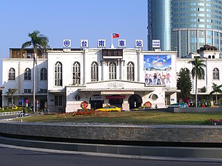
Tainan is a railway station in Tainan, Taiwan served by Taiwan Railways Administration. Situated in centre of the old town square in the East District of Tainan, Tainan Station is the main station of the city and also one of the major stations along the western trunk line in Taiwan. The Shalun line, opened in 2011, allows through services to link the station with THSR Tainan Station.
The Penghu National Scenic Area is one of the National Scenic Areas of the Republic of China (Taiwan), and covers most, but not all of the islands and islets that form Penghu County. These islands have a total of 320 kilometers of shoreline. A National Scenic Area is not a National Park. National Scenic Areas fall within the control of the Tourism Bureau of the Ministry of Transportation and Communications of the Republic of China, while national parks fall within the jurisdiction of the Ministry of Interior of the Republic of China. The philosophies that govern the development of the two types of areas differ. For a national park the emphasis is on the preservation of natural and cultural resources, and development for human utilization is definitely a secondary priority. For a national scenic area, the priorities are more balanced between preservation and tourism utilization. This has led to conflicts between preservationists and those more favorable to the development of the area. The National Park Law of the Republic of China only applies to the latter areas. Studies about the project were first debated since the beginning of 1990 and, after a year of evaluations carried out by the Tourism Bureau of the Ministry of Transportation and Communications of the Republic of China, it was officially created in February 1991, when the Penghu office was finally established. The aim of the project was to "efficiently utilize the local resources and help Penghu's economic growth", while building vacation spots on the coast of Taiwan's only island county to attract both Taiwanese nationals and foreigners, making of Penghu an "International tourism vacation center". It is a well known scenic area for its sandy beaches. The tourist season in Penghu starts in April and peaks from June through August. The Scenic Area attracts thousands of weekenders with its brisk sea breezes and scenery. But when the autumn gales begin to blow in October, the archipelago becomes deserted until April, when warmer weather seems to thaw the local tourism industry. In addition to its rich oceanic resources, Penghu offers fantastic sights of basalt column formations. The scenic area lures more than 200 species of migratory birds, making it an important spot for Asia's birdwatchers. It was not always like this: for much of the second half of the past century, the Government of the Republic of China saw the islands in mainly political and military terms, as a naval base: "Penghu was regarded as a military base until the early 1990s. As a result, the central government never wanted to develop the islands, which resulted in Penghu's shortages of water and electricity and, of course, a lot of five-star hotels".

Taijiang National Park is a national park in Tainan, Taiwan.

The Haomeiliao Wetland is a wetland in Budai Township, Chiayi County, Taiwan.

South Penghu Marine National Park is a national park of Taiwan in the south of Penghu Islands. The marine park includes the islands of Dongjiyu, Xijiyu, Dongyupingyu, Xiyupingyu, other smaller islets and surrounding waters. It is managed by the Marine National Park Headquarters.
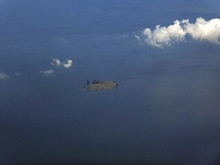
Mianhua Islet is a 0.133 km2 (0.051 sq mi) volcanic island in Zhongzheng District, Keelung, Taiwan, located in the East China Sea. Pingfong Rock, just east of the islet, is the easternmost point under the actual control of Taiwan (ROC).

Paiyun Lodge is an accommodation mountain lodge in Taiwan's Yushan National Park, with an altitude of 3,402 metres (11,161 ft) and located 2.4 kilometres (1.5 mi) below the west slope of the main peak of Yushan. This is the most famous and popular mountain lodge in Taiwan. Hikers come here to rest and stay before climbing the peaks of Yushan Mountain. Due to extreme popularity, a lottery is required for this accommodation. The winning rate has been recorded as low as 1%. Since January 2002, Paiyun Lodge was originally operated and managed by the Forestry Bureau, but has now been fully managed by the Yushan National Park Headquarters. Today, the appearance of Paiyun Lodge is a two-story steel frame structure after the renovation was completed in June 2013. In terms of energy system, a solar power supply system is installed on the roof, and a lithium-ion battery energy storage system is installed.
The National Park Service is the government agency of the Ministry of the Interior of Taiwan responsible for the management of national parks, national nature parks, wetlands, and coastal areas.


