Related Research Articles
The Whitewater River is a small permanent stream in western Riverside County, California, with some upstream tributaries in southwestern San Bernardino County. The river's headwaters are in the San Bernardino Mountains, and it terminates at the Salton Sea in the Colorado Sonoran Desert. The area drained by the Whitewater River is part of the larger endorheic Salton Sea drainage basin.

Temescal Creek is an approximately 29-mile-long (47 km) watercourse in Riverside County, in the U.S. state of California. Flowing primarily in a northwestern direction, it connects Lake Elsinore with the Santa Ana River. It drains the eastern slopes of the Santa Ana Mountains on its left and on its right the western slopes of the Temescal Mountains along its length. With a drainage basin of about 1,000 square miles (2,600 km2), it is the largest tributary of the Santa Ana River, hydrologically connecting the 720-square-mile (1,900 km2) San Jacinto River and Lake Elsinore watersheds to the rest of the Santa Ana watershed. However, flowing through an arid rain shadow zone of the Santa Ana Mountains, and with diversion of ground water for human use, the creek today is ephemeral for most of its length, except for runoff from housing developments and agricultural return flows.
Temescal Mountains, also known as the Sierra Temescal, are one of the northernmost mountain ranges of the Peninsular Ranges in western Riverside County, in Southern California in the United States. They extend for approximately 25 mi (40 km) southeast of the Santa Ana River east of the Elsinore Fault Zone to the Temecula Basin and form the western edge of the Perris Block.
The Carrizo Creek and Carrizo Wash in California are a stream and an arroyo that the stream flows into, in San Diego County, California and Imperial County, California.
San Felipe Creek is a stream in Imperial and San Diego Counties of California. It arises in the Volcan Mountains of San Diego County 33°11′57″N116°37′35″W, and runs eastward, gathering the waters of most of the eastern slope of the mountains and desert of the county in the San Sebastian Marsh before it empties into the Salton Sea. It is probably the last remaining perennial natural desert stream in the Colorado Desert region. In 1974, the San Felipe Creek Area was designated as a National Natural Landmark by the National Park Service.
Rice Canyon Creek is a tributary creek or arroyo of Temescal Creek in Riverside County, California. Rice Canyon Creek has its source at the head of Rice Canyon at an elevation of 3440 feet in the Santa Ana Mountains at 33°41′54″N117°24′11″W east of the 4313 foot peak on the north south divide of the range. It is a wash that runs down from the canyon mouth 33°41′07″N117°27′08″W at 1631 feet to its mouth at its confluence with Temescal Creek near Alberhill, California at an elevation of 1220 feet. Rice Canyon Creek has a tributary, Bishop Canyon Creek which enters the wash on the left a little below the mouth of Rice Canyon at 33°42′05″N117°24′07″W.
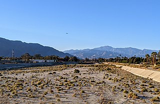
Alberhill Canyon is an informally named valley and arroyo in the Temescal Mountains of Riverside County, California. It is named for the former mining settlement and populated place of Alberhill that lay opposite the mouth of the arroyo at its confluence with Temescal Creek.

Laguña Creek also formerly also known as Tyende Creek, is a stream in the Navajo and Apache Counties of Arizona. Laguña Creek has its source at 36°41′15″N110°30′36″W, at the confluence of Long Canyon and Dowozhiebito Canyon at an elevation of 6,325 feet at the head of Tsegi Canyon. Its mouth is in the Chinle Valley at its confluence with Chinle Wash which together forms Chinle Creek, at an elevation of 4,774 feet. Chinle Creek is a tributary of San Juan River which is in turn a tributary of the Colorado River.

Chinle Creek is a tributary stream of the San Juan River in Apache County, Arizona and San Juan County, Utah. Its source is at 36°53′40″N109°44′37″W, the confluence of Laguña Creek and the Chinle Wash arroyo. Its name is derived from the Navajo word ch'inili meaning 'where the waters came out. Its sources is in Canyon de Chelly National Monument where Canyon de Chelly and Canyon del Muerto have their confluence at an elevation of 5,616 feet at 36°08′35″N109°29′17″W. It then trends northwest to its confluence with Laguña Creek where it forms Chinle Creek, 7 miles northeast of Dennehotso, Arizona at an elevation of 4,774 feet.
Mason Valley is a valley in San Diego County, California. Mason Valley was named after a settler, James E. Mason who established a ranch in the valley in the later 19th century. The mouth of the valley is at an elevation of 1,995 feet / 608 meters, at the point where the valley narrows into a canyon where the Vallecito Wash continues as Vallecito Creek and passes between the Sawtooth Range and the Vallecito Mountains. The head of Mason Valley is at an elevation of 2550 feet at 33°01′05″N116°28′53″W at the junction of Oriflamme Canyon and Rodriguez Canyon where Vallecito Wash has its source.
Vallecito Wash is a wash part of Vallecito Creek, a tributary stream of Carrizo Creek, in San Diego County, California.
Rodriguez Canyon is a steep mountain canyon, in San Diego County, California. It has its head at 33°02′55″N116°31′43″W at an elevation of 4,120 feet in the Cuyamaca Mountains. Is mouth is at 2,549 feet / 777 meters, at its confluence with Oriflamme Canyon, where they form the head of Vallecito Wash, at the northwestern end of Mason Valley.
Palm Canyon Wash is an arroyo and tributary ephemeral stream or wash running east from the Jacumba Mountains in San Diego County, California to its confluence with Coyote Wash, east northeast of Ocotillo in the Yuha Desert of Imperial County, California at an elevation of 239 feet / 73 meters. Its source is on the east slope of the Jacumba Mountains at 32°42′28″N116°10′10″W, at an elevation of 4,000 feet.
Bull Canyon is a canyon at the top of Palm Canyon Wash, which is a tributary to the Whitewater River, in Riverside County, California. Bull Canyon and the creek of Palm Canyon Wash heads at 33°36′47″N116°33′23″W, at an elevation of 6,165 feet in the southern western slope of a ridge in the San Jacinto Mountains. The waters of the creek of Palm Canyon Wash are augmented by Bull Canyon Spring at 33°35′22″N116°33′24″W, at an elevation of 5,331 feet / 1,625 meters. The mouth of Bull Canyon is at an elevation of 4,508 feet / 1,374 meters at the head of Palm Canyon. The mouth of an unnamed creek flows north down from Vandeventer Flat into the head of Palm Canyon at its confluence with Palm Canyon Wash at 33°34′08″N116°31′43″W at an elevation of 4,460 feet.
Bull Canyon Spring is a spring in Bull Canyon, in the upper reach of Palm Canyon, in Riverside County, California. It is located at an elevation of 5,331 feet / 1,625 meters.
Animas Creek is an intermittent stream in the Animas Valley within Hidalgo County, New Mexico. Is source is located at the confluence of Foster Draw and Taylor Draw, at 31°30′28″N108°52′09″W an elevation of 5,151 feet. Its mouth is in the Animas Valley, in at an elevation of 4,662 feet. However, topographic maps show its wash runs farther northward to the southern outskirts of Animas, New Mexico at 31°55′51″N108°49′36″W.
San Roque Canyon is a canyon or valley in Santa Barbara County, California. San Roque Creek tributary to Arroyo Burro flows through it. The Canyon heads at a point at an elevation of 3,400 feet / 1,000 meters, at 34°29′34″N119°42′58″W, 0.8 miles west of La Cumbre Peak and trends south-southwest four miles to 34°26′20″N119°44′41″W, near the confluence of San Roque Creek with Arroyo Burro at an elevation of 187 feet / 57 meters.
Cañon del Muerto is a canyon, in Sierra County, New Mexico.
Cañada Viviancito, is a tributary arroyo of Alamosa Creek, and a side cañada in Monticello Canyon, in Sierra County, New Mexico. Its mouth is at its confluence with the creek at an elevation of 5,551 feet within Monticello Canyon. The source of the arroyo is at an elevation of 6,000 feet, while the head of the cañada is at an elevation of 6,060 feet at 33°28′06″N107°29′05″W.
References
33°47′41″N116°28′22″W / 33.79472°N 116.47278°W

| | This Riverside County, California-related article is a stub. You can help Wikipedia by expanding it. |