
The Haute Route, is the name given to a route undertaken on foot or by ski touring between Chamonix in France and Zermatt in Switzerland.

The Tour du Mont Blanc or TMB is one of the most popular long-distance walks in Europe. It circles the Mont Blanc massif, covering a distance of roughly 170 kilometres (110 mi) with 10 kilometres (6.2 mi) of ascent/descent and passes through parts of Switzerland, Italy and France.

Col de la Forclaz is a mountain pass in the Alps in the Canton of Valais in Switzerland. It connects Martigny at 471 m (1,545 ft) and Le Châtelard (Finhaut). The road from Martigny to the Col has an average gradient of 6% but in parts is closer to 8%. After the Col, and Le Châtelard, the road leads to Chamonix in France via Vallorcine and the Col des Montets.

The Vanoise massif is a mountain range of the Graian Alps, located in the Western Alps. After the Mont Blanc Massif and the Massif des Écrins it is the third highest massif in France, reaching a height of 3,885m at the summit of Grande Casse. It lies between Tarentaise Valley to the north and the Maurienne valley in the south. The range is the site of France's first National Park in 1963, the Vanoise National Park. The ski resorts of Tignes and Val-d'Isère and the 2,770m high Col de l'Iseran are located in the eastern part of the range.

Le Portalet is a mountain of the Mont Blanc massif, located west of Praz de Fort in the canton of Valais. It lies on the range between the glaciers of Trient and Saleina. It has two important subsidiary summits: Grand Clocher du Portalet and Petit Clocher du Portalet. The latter forms a needle and is particularly hard to climb.

The Pointe du Tsaté is a mountain of the Swiss Pennine Alps, overlooking Les Haudères in the canton of Valais. It lies between the valleys of Hérens and Moiry. On its east side is the lake of Moiry.

The Aiguille du Tour is a mountain in the Mont Blanc massif, located on the border between Switzerland and France. The voie normale on the mountain is graded F (facile) and can be climbed from either the Albert Premier Hut on the French side or the Trient Hut on the Swiss side.
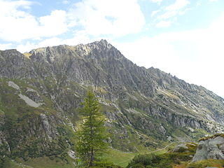
The Luisin is a mountain of the Chablais Alps, overlooking Les Marécottes in the canton of Valais. It lies east of the Tour Sallière, on the range between the lake of Salanfe and the valley of Trient.
The Pointe Ronde is a mountain of the Mont Blanc massif, overlooking Trient in the canton of Valais. It lies near the northern end of the Arête de la Lys, the ridge descending in a north-westerly direction from the Génépi towards the Col de la Forclaz.

The Aiguilles Dorées are a multi-summited mountain of the Mont Blanc massif, overlooking the Plateau du Trient in the canton of Valais. They lie east of the Petite Fourche, on the range between the glaciers of Trient and Saleina.

The Petite Pointe d'Orny is a mountain of the Mont Blanc Massif, overlooking the Trient Glacier in the canton of Valais. It lies north of the Pointe d'Orny.

Val Ferret is the name of the two separate valleys, departing from the Col Ferret on the border between Italy and Switzerland, on the southern and eastern sides of the Mont Blanc Massif. The Swiss valley drains northeastwards towards Orsières and on into the Rhône basin; whereas the Italian valley drains southwestwards towards Courmayeur and on into the Po basin.

Pointe Kurz is a mountain of the Mont Blanc Massif, located on the border between France and Switzerland. It lies between the glaciers of Argentière and L'A Neuve, west of La Fouly, the closest locality.
The Pointe des Ecandies is a mountain of the Mont Blanc Massif, located between Trient and Champex in the canton of Valais. It is located north of the Pointe d'Orny and east of the Trient Glacier.

Le Châtelet is a mountain of the Swiss Mont Blanc massif, overlooking Orsières in the canton of Valais. It lies between the valleys of Orny and Saleina.

The Bec du Corbeau is a mountain of the Chablais Alps, overlooking Morgins in the Swiss canton of Valais. It lies west of Pointe de Bellevue, on the watershed between the valleys of the Dranse d'Abondance and Illiez. The French border runs west of the mountain.

The Pointe des Mossettes is a mountain of the Chablais Alps, overlooking Les Crosets in the Swiss canton of Valais. The French border runs west of the summit on a straight line, although the mountain lies on the main watershed between the Dranse river basin and the Val d'Illiez.

The Col de Balme is a high mountain pass of the Alps, located on the border between Switzerland and France. It connects Trient in the Swiss canton of Valais to Argentière in the French department of Haute-Savoie. The pass lies between the summits of Tête de Balme and Les Grandes Otanes.

Praz de Lys - Sommand is a twinned ski resort starting at a high altitude and composed of Sommand resort and Praz de Lys resort both linked by ski trails and chair lifts over and around their dividing mountains. Sommand sits high above its village of Mieussy and Praz de Lys sits above Taninges. The ski resort of Les Gets is also nearby Praz de Lys, about 15 minutes drive. It was opened in approximately 1978.

The Grande Aiguille Rousse is a mountain peak of the Graian Alps in Savoie, France, situated between the Maurienne and Tarentaise valleys near the Italian border. Reaching an altitude of 3,482 meters, it exceeds its junior to the west, the Petite Aiguille Rousse, by just 50 m (160 ft). Not far from Levanna, the Grande Aiguille Rousse overlooks Serrù Lake and the Gran Paradiso National Park in Italy.


