Protohistory of Ireland

Last updated

The prehistory of Ireland included a protohistorical period, when the literate cultures of Greece and Rome began to take notice of it, and a further proto-literate period of ogham epigraphy, before the early historical period began in the 5th century. Attempts have been made to reconstruct the political developments of this period by reference to early medieval Irish genealogical texts.

Contents

Ireland in Classical literature

Early references

Classical writers occasionally refer to Ireland under a variety of names, but these references contain little reliable information. For example, Diodorus Siculus claims that the Prettanoi of the island of Iris eat human flesh. [1] Strabo, who calls the island Ierne, repeats the accusation, adding that they consider it honourable to eat their dead fathers, and openly have sex with their mothers and sisters (although he is sceptical about his sources). [2] Pomponius Mela calls it Iuverna and says that, although the climate is unfavourable for grain, grass grows so richly that cattle burst if unrestrained from eating it. [3] Julius Caesar, in his Commentarii de Bello Gallico , is the first to call the island Hibernia , describes it as about half the size of Britain, and correctly places it to the west of Britain [4] – unlike Strabo, who places it to the north.

Tacitus

Tacitus says that his father-in-law Gnaeus Julius Agricola, while governor of Britain (AD 78–85), considered conquering Ireland, believing it could be held with one legion plus auxiliaries, and entertained an exiled Irish petty king with the intention of making him the pretext for conquest. [5] Parallels have been drawn with the Irish legend of Túathal Techtmar, who is said to have been exiled to Britain as a child and returned with an army to claim the kingship of Tara in the 1st century. [6] Tacitus also says that most of the harbours and approaches to Ireland were known through commerce, but inaccurately locates the island between Britain and the Iberian peninsula. [5]

Juvenal

The 2nd-century poet Juvenal, in his second Satire , contrasting the victories of the Roman army with the low morals of the people at home in Rome, says that, as well as conquering Britain and the Orkney islands, "we have advanced arms beyond the shores of Iuverna". Although Juvenal is not writing history, it is possible that he is referring to a genuine Roman military expedition to Ireland. [7]

Ptolemy

The 2nd-century Alexandrian Greek writer Ptolemy, one of the most important geographers, mathematicians and astronomers in the ancient world, refers to Ireland in two of his works. In the astronomical treatise known as the Almagest he gives the latitudes of an island he calls Mikra Brettania (Μικρὰ Βρεττανία) or "Little Britain" (the south of the island at 58 degrees, the north at 61 degrees). In his Geography , at the same latitudes, he places the Prettanic island Iwernia, next to its neighbour, the Prettanic island Albion (Great Britain). The Geography contains the most detailed account of Ireland in classical literature, giving the latitude and longitude of six promontories, fifteen river mouths, ten settlements and nine islands, and naming sixteen population groups. [8]

Island of Ireland NASA.png

Rhobogdioi
Wenniknioi
Darinoi
Erdinoi
Woluntioi
Magnatai
Eblanioi
Kaukoi
Auteinoi
Ganganoi
Usdiai
Wellaboroi
Manapioi
Koriondoi
Brigantes
Iwernoi

Peoples of Ireland according to Ptolemy's Geography . [8]

North coast

Ptolemy describes the northern coast of Ireland, from the Northern Promontory (possibly Bloody Foreland or Rossan Point in County Donegal) in the west, to the Wenniknion promontory (probably Malin Head), the mouth of the river Widwa (probably the Foyle), the mouth of the river Argita (perhaps the Bann) and the Rhobogdion promontory (Fair Head, County Antrim) in the east. The peoples who inhabit the north coast are the Wenniknioi in the west and the Rhobogdioi in the east. [8]

West coast

The west coast is poorly represented compared to the other three, and identification of the names Ptolemy gives is speculative. He begins with the Northern Promontory (see above), and working north to south names the river Rhawiu (possibly the Erne); the town Magnata (a settlement of the Magnatai people, possibly somewhere in County Sligo); the mouth of the rivers Libniu (possibly Clew Bay), Ausoba (perhaps Galway Bay) Senu (probably the Shannon, although placed too far to the north), Dur (possibly Dingle Bay) and Iernu (possibly the Kenmare), and the Southern Promontory (any one of Slea Head, Bray Head, Dursey Head and Mizen Head). Peoples of this coast are: the Erdinoi near Donegal Bay; the Magnatai or Nagnatai of County Mayo and Sligo; the Auteinoi between County Galway and the Shannon, identifiable with the early medieval Uaithni; the Ganganoi , also known in north Wales, and the Wellaboroi in the far south-west. [8] [9] [10]

South coast

The south coast stretches from the Southern Promontory to the mouths of the rivers Dabrona (possibly the Lee or the Blackwater) and Birgu (probably the Barrow) and the Sacred Promontory (Carnsore Point, County Wexford). Peoples of the south coast are the Iwernoi in the west, who share their name with the island, Iwernia, and can be identified with the early medieval Érainn; the Usdiai, and the Brigantes in the east, who share their name with a people of Roman Britain. [8] [9]

East coast

From the Sacred Promontory in the south to the Rhobogdion promontory in the north, Ptolemy names the river Modonnu (possibly the Slaney, but more likely the Avoca), the town of Manapia (a settlement of the Manapii), the river Oboka (perhaps the Liffey; the river Avoca takes its modern name from a misinterpretation of Ptolemy's Oboka), the town of Eblana (a settlement of the Eblanoi, formerly mistakenly identified with Dublin), the river Buwinda (the Boyne), the promontory Isamnion, the river Winderios (possibly Carlingford Lough, Dundrum Bay or Strangford Lough), and the river Logia (Belfast Lough, Loch Laoigh in Irish). Peoples named, from south to north, are: the Koriondoi ; the Manapioi, possibly related to the Menapii of Gaul; the Kaukoi , probably not related to the Germanic Chauci of the Low Countries; the Eblanoi ; the Woluntioi, identifiable with the early medieval Ulaid; and the Darinoi . [8]

Later references

Roman sources mention raids on Britain by Saxons of north-west Germany, by Picts from Scotland and by two groups of people usually associated with Ireland, the Scotti and the Atacotti. The origins and meanings of Scotti and Atacotti is uncertain. Atacotti disappears with the Romans. Scotti means Gaels to Adomnán in the late seventh century, but not to Columbanus in the early sixth century, who uses the older term Iberi instead. The Scotti are perhaps a confederation of tribes in Ulster, and the Atacotti one in Leinster, but this is not certain. [11]

See also

Related Research Articles

<span class="mw-page-title-main">Gnaeus Julius Agricola</span> Roman governor and general (40–93)

Gnaeus Julius Agricola was a Roman general and politician responsible for much of the Roman conquest of Britain. Born to a political family of senatorial rank, Agricola began his military career as a military tribune under Governor Gaius Suetonius Paulinus. In his subsequent career, he served in a variety of political positions in Rome. In 64, he was appointed quaestor in Asia province. Two years later, he was appointed Plebeian Tribune, and in 68, he was made praetor. During the Year of the Four Emperors in 69, he supported Vespasian, general of the Syrian army, in his bid for the throne.

<span class="mw-page-title-main">Pytheas</span> Ancient Greek geographer (born ca. 350 BC)

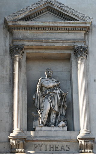
Pytheas of Massalia was a Greek geographer, explorer and astronomer from the Greek colony of Massalia. He made a voyage of exploration to northwestern Europe in about 325 BC, but his account of it, known widely in antiquity, has not survived and is now known only through the writings of others.

<span class="mw-page-title-main">Suebi</span> Historical ethnic grouping of Germanic tribes

The Suebi or Suebians were a large group of Germanic peoples originally from the Elbe river region in what is now Germany and the Czech Republic. In the early Roman era they included many peoples with their own names such as the Marcomanni, Quadi, Hermunduri, Semnones, and Lombards. New groupings formed later, such as the Alamanni and Bavarians, and two kingdoms in the Migration Period were simply referred to as Suebian.

<span class="mw-page-title-main">Menapii</span> Belgic tribe

The Menapii were a Belgic tribe dwelling near the North Sea, around present-day Cassel, during the Iron Age and the Roman period.

<span class="mw-page-title-main">Lingones</span> Gallic tribe

The Lingones were a Gallic tribe of the Iron Age and Roman periods. They dwelled in the region surrounding the present-day city of Langres, between the provinces of Gallia Lugdunensis and Gallia Belgica.

Eblana is an ancient Irish settlement that appears in the Geographia of Claudius Ptolemaeus (Ptolemy), the Greek astronomer and cartographer, around the year 140 AD. It was traditionally believed by scholars to refer to the same site as the modern city of Dublin. The 19th-century writer Louis Agassiz used Eblana as a Latin equivalent for Dublin. However, more recent scholarship favours the north County Dublin seaside village of Loughshinny due to its proximity to Drumanagh, an important trading site with strong links to Roman Britain; it has even been described as a bridgehead of a possible Roman invasion. However, there is no definitive proof to tie Eblana to any location, so its exact identity is still a matter of speculation.

<span class="mw-page-title-main">Sicambri</span> Roman-era Germanic people

The Sicambri, also known as the Sugambri or Sicambrians, were a Germanic people who during Roman times lived on the east bank of the river Rhine, in what is now Germany, near the border with the Netherlands. They were first reported by Julius Caesar, who described them as Germanic (Germani), though he did not necessarily define this in terms of language.

The Selgovae were a Celtic tribe of the late 2nd century AD who lived in what is now the Stewartry of Kirkcudbright and Dumfriesshire, on the southern coast of Scotland. They are mentioned briefly in Ptolemy's Geography, and there is no other historical record of them. Their cultural and ethnic affinity is commonly assumed to have been Brittonic.

Túathal Techtmar, son of Fíachu Finnolach, was a High King of Ireland, according to medieval Irish legend and historical tradition. He is said to be the ancestor of the Uí Néill and Connachta dynasties through his grandson Conn of the Hundred Battles. The name may also have originally referred to an eponymous deity, possibly even a local version of the Gaulish Toutatis.

<span class="mw-page-title-main">Angrivarii</span> Germanic people in Roman times

The Angrivarii were a Germanic people of the early Roman Empire, who lived in what is now northwest Germany near the middle of the Weser river. They were mentioned by the Roman authors Tacitus and Ptolemy.

<span class="mw-page-title-main">Cassiterides</span> Ancient geographical name used to refer to an unidentified group of islands

The Cassiterides are an ancient geographical name used to refer to a group of islands whose precise location is unknown, but which was believed to be situated somewhere near the west coast of Europe.

The Novantae were a people of the late 2nd century who lived in what is now Galloway and Carrick, in southwesternmost Scotland. They are mentioned briefly in Ptolemy's Geography, and there is no other historical record of them. Excavations at Rispain Camp, near Whithorn, show that it was a large fortified farmstead occupied between 100 BC and 200 AD, indicating that the people living in the area at that time were engaged in agriculture.

<span class="mw-page-title-main">Drumanagh</span>

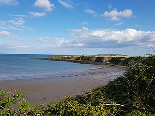
Drumanagh is a headland near the village of Loughshinny, in the north east of Dublin, Ireland. It features an early 19th-century Martello tower and a large Iron Age promontory fort which has produced Roman artefacts.

The Eblani ( Ἐβλάνοι) or Eblanii ( Ἐβλάνιοι) were a people of ancient Ireland uniquely recorded in Ptolemy's 2nd-century Geography, in which they inhabit a region on the east coast, roughly north of County Dublin. Ptolemy also lists a "city" called Eblana ( Ἔβλανα), which he locates between the estuaries of the rivers Buvinda (Βουουίνδα) and Oboca (᾿Οβόκα), implying a coastal site between the Boyne and probably the Liffey respectively. O'Rahilly tentatively suggested that the tribal name, which he speculatively reconstructed as *Ebodanī, may have survived in the toponym Edmann, a region on the east coast, probably in County Louth, occasionally mentioned in early texts. O'Rahilly's line of reasoning was inspired by the form Ebdanoi [ Ἐβδανοί] found in one manuscript family of Ptolemy's work, but this variant is demonstrably the result of a transcriptional error for Eblanoi ( Ἐβλάνοι) in a majuscule script, where Λ has been misread as Δ, and not vice versa as O'Rahilly reasoned. The associated settlement of the Eblani is spelled Eblana in all surviving manuscripts, with only minor accentual differences. This strongly suggests that Eblanoi [Ἐβλάνοι] was Ptolemy's original version, and Ebdanoi [Ἐβδανοί] the error. This defective reading cannot therefore be cited in support of his hypothesis.

The Gangani (Γαγγανοι) were a people of ancient Ireland who are referred to in Ptolemy's 2nd-century Geography as living in the south-west of the island, probably near the mouth of the River Shannon, between the Auteini to the north and the Uellabori to the south. There appears to have been a people of the same name in north-west Wales, as Ptolemy calls the Llŷn Peninsula the "promontory of the Gangani".

Daedala or Daidala was a city of the Rhodian Peraea in ancient Caria, or a small place, as Stephanus of Byzantium says, on the authority of Strabo.

<span class="mw-page-title-main">Hiberno-Roman relations</span> Historical social relations between Ireland and ancient Rome

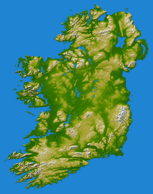
Hiberno-Roman relations refers to the relationships which existed between Ireland (Hibernia) and the ancient Roman Empire, which lasted from the 1st century BC to the 5th century AD in Western Europe. Ireland was one of the few areas of western Europe not conquered by Rome.

The Marsaci or Marsacii were a tribe in Roman imperial times, who lived within the area of the Rhine–Meuse–Scheldt delta, under Roman domination.

Lough Boderg is a lake on the River Shannon in County Roscommon and County Leitrim, Ireland.

<span class="mw-page-title-main">Ptolemy's map of Ireland</span> Ancient map of Ireland

Ptolemy's map of Ireland is a part of Ptolemy's "first European map" in the series of maps included in his Geography, which he compiled in the second century AD in Roman Egypt and which is the oldest surviving map of Ireland. Ptolemy's own maps do not survive, but is known from manuscript copies made during the Middle Ages and from the text of the Geography, which gives coordinates and place names. Ptolemy almost certainly never visited Ireland, but compiled the map based on military, trader and traveller reports and his own mathematical calculations. Given the creation process, the time period involved and the fact that the Greeks and Romans had limited contact with Ireland, it is considered remarkably accurate.

References

  1. Diodorus Siculus, Historical Library 5.32
  2. Strabo, Geographica 4.5.4
  3. Pomponius Mela, De Chorographia 3.53
  4. Julius Caesar, Commentarii de Bello Gallico 5.13
  5. 1 2 Tacitus, Agricola 24
  6. R. B. Warner, "Tuathal Techtmar: A Myth or Ancient Literary Evidence for a Roman Invasion?", Emania 13, 1995, pp. 23–32
  7. Philip Freeman, Ireland and the Classical World, University of Texas Press, 2001, pp. 62-64
  8. 1 2 3 4 5 6 Philip Freeman, Ireland and the Classical World, University of Texas Press, 2001, pp. 64-84
  9. 1 2 T. F. O'Rahilly, Early Irish History and Mythology, Dublin Institute for Advanced Studies, 1946
  10. Eoin MacNeill, "Early Irish population groups: their nomenclature, classification and chronology", Proceedings of the Royal Irish Academy (C) 29, 1911, pp. 59–114
  11. Charles-Edwards, pp. 158–160. Origins in the Hebrides have also been suggested for the Atacotti. The Late Roman army as recorded by the Notitia Dignitatum included auxilia palatina named for the Atacotti, the normal interpretation of such names being that they were recruited from prisoners of war.