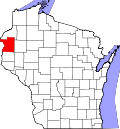
Range, Wisconsin

Last updated
Range, Wisconsin
Unincorporated community
USA Wisconsin location map.svg
Red pog.svg
Range, Wisconsin
Usa edcp location map.svg
Red pog.svg
Range, Wisconsin
Coordinates: 45°23′44″N92°17′05″W / 45.39556°N 92.28472°W / 45.39556; -92.28472 Coordinates: 45°23′44″N92°17′05″W / 45.39556°N 92.28472°W / 45.39556; -92.28472
Country United States
State Wisconsin
County Polk
Elevation 1,168 ft (356 m)
Time zone Central (CST) (UTC-6)
  Summer (DST) CDT (UTC-5)
Area code(s) 715 & 534
GNIS feature ID 1572071 [1]

Range is an unincorporated community located in the towns of Apple River and Beaver, Polk County, Wisconsin, United States. [1] It is along U.S. Highway 8 and County Road D, 60th Street.

Unincorporated area Region of land not governed by own local government

In law, an unincorporated area is a region of land that is not governed by a local municipal corporation; similarly an unincorporated community is a settlement that is not governed by its own local municipal corporation, but rather is administered as part of larger administrative divisions, such as a township, parish, borough, county, city, canton, state, province or country. Occasionally, municipalities dissolve or disincorporate, which may happen if they become fiscally insolvent, and services become the responsibility of a higher administration. Widespread unincorporated communities and areas are a distinguishing feature of the United States and Canada. In most other countries of the world, there are either no unincorporated areas at all, or these are very rare; typically remote, outlying, sparsely populated or uninhabited areas.

Apple River, Wisconsin Town in Wisconsin, United States

Apple River is a town in Polk County, Wisconsin, United States. The population was 1,067 at the 2000 census. The unincorporated community of Range is located partially in the town.

Beaver, Polk County, Wisconsin Town in Wisconsin, United States

Beaver is a town in Polk County, Wisconsin, United States. The population was 753 at the 2000 census. The village of Turtle Lake and the unincorporated community of Range are located partially in the town.

Notes


Related Research Articles

Wisconsin A north-central state of the United States of America

Wisconsin is a U.S. state located in the north-central United States, in the Midwest and Great Lakes regions. It is bordered by Minnesota to the west, Iowa to the southwest, Illinois to the south, Lake Michigan to the east, Michigan to the northeast, and Lake Superior to the north. Wisconsin is the 23rd largest state by total area and the 20th most populous. The state capital is Madison, and its largest city is Milwaukee, which is located on the western shore of Lake Michigan. The state is divided into 72 counties.

Wood County, Wisconsin County in the United States

Wood County is a county located in the U.S. state of Wisconsin. As of the 2010 census, the population was 74,749. Its county seat is Wisconsin Rapids. The county is named after Joseph Wood, a member of the Wisconsin State Assembly.

Marathon County, Wisconsin County in the United States

Marathon County is a county located in the U.S. state of Wisconsin. As of the 2010 census, the population was 134,063. Its county seat is Wausau. It was founded in 1850, created from a portion of Portage County. At that time the county stretched to the northern border with the upper Michigan peninsula. It is named after the battlefield at Marathon, Greece.

Kenosha County, Wisconsin County in the United States

Kenosha County is a county in the southeastern corner of the U.S. state of Wisconsin. Its population in 2017 was estimated to be 168,065, making it the eighth most populous county in Wisconsin. The county is named after the county seat, Kenosha, the fourth largest city in Wisconsin.

Douglas County, Wisconsin County in the United States

Douglas County is a county located at the northwest corner of the U.S. state of Wisconsin. As of the 2010 census, the population was 44,159. Its county seat is Superior.

Columbia County, Wisconsin County in the United States

Columbia County is a county located in the U.S. state of Wisconsin. As of the 2010 census, the population was 56,833. Its county seat and largest city is Portage. The county was created in 1846 as part of Wisconsin Territory.

Wisconsin Dells, Wisconsin City in Wisconsin, United States

Wisconsin Dells is a city in south-central Wisconsin, with a population of 2,678 people as of the 2010 census. It straddles four counties: Adams, Columbia, Juneau, and Sauk. The city takes its name from the Dells of the Wisconsin River, a scenic, glacially formed gorge that features striking sandstone formations along the banks of the Wisconsin River. Together with the nearby village of Lake Delton, the city forms an area known as "the Dells", a popular Midwestern tourist destination.

A township in the United States is a small geographic area.

Western Upland

The Western Upland is a geographical region covering much of the western half of the U.S. state of Wisconsin. It stretches from southern Polk County, Wisconsin in the north to the state border with Illinois in the south, and from Rock County in the east to the Mississippi River in the west.

Baileys Harbor Range Lights lighthouse in Wisconsin, United States

The Baileys Harbor Range Lights are a pair of lighthouses arranged in a range light configuration, located near Baileys Harbor in Door County, Wisconsin, United States.

Plum Island Range Lights lighthouse in Wisconsin, United States

The Plum Island Range Lights are a pair of range lights located on Plum Island in Door County, Wisconsin. They were part of the Plum Island United States Life-Saving Station. Plum Island was transferred to the United States Fish and Wildlife Service in 2007 and became part of the Green Bay National Wildlife Refuge. The life-saving station was listed on the National Register of Historic Places in 2010. Plum Island is closed to the public to protect ground nesting migratory birds.

Kewaunee Pierhead Light lighthouse in Wisconsin, United States

The Kewaunee Pierhead lighthouse is a lighthouse located near Kewaunee in Kewaunee County, Wisconsin.

South Range, Wisconsin Unincorporated community in Wisconsin, United States

South Range is an unincorporated community, located in the town of Parkland, Douglas County, Wisconsin, United States.

Plum Island (Wisconsin) island in Door County, Wisconsin


Plum Island is an island in Lake Michigan in the southern part of the town of Washington in Door County, off the tip of the Door Peninsula in the U.S. state of Wisconsin. The uninhabited island has a land area of 1.179 square kilometres (0.455 sq mi) or 117.87 hectares. The island is a bird sanctuary under control of the United States Fish and Wildlife Service and part of the Green Bay National Wildlife Refuge. The island also holds the unmanned Plum Island Range Lights. There are an estimated 250 shipwrecks off the island's shores.

Haven, Wisconsin Unincorporated community in Wisconsin, United States

Haven is an unincorporated community in the town of Mosel in Sheboygan County, Wisconsin, United States.

Dewey Marsh, Wisconsin

The Dewey Marsh is a state wildlife area in Portage County, Wisconsin, United States.

Loreta, Wisconsin Unincorporated community in Wisconsin, United States

Loreta is an unincorporated community in the town of Bear Creek, Sauk County, Wisconsin, United States. The community is usually known as "Loreto", sometimes spelled "Loretto". It was named after Loreto, Italy.

Fairfield (community), Wisconsin Unincorporated community in Wisconsin, United States

Fairfield is an unincorporated community located in the towns of Bradford in Rock County and Darien in Walworth County, Wisconsin, United States.

Center (community), Wisconsin Unincorporated community in Wisconsin, United States

Center is an unincorporated community in the Town of Center, Rock County, Wisconsin, United States. Located in section 22 of Township 3 North Range 11 East of the Fourth Principal Meridian, Center has been published on USGS maps since 1891. Bethel Cemetery, the Town of Center town hall and Zion Lutheran Church are located in the community in section 22 at the intersection of Rock County Highway A and Church Road.