
DeKalb County is located in the north central portion of the U.S. state of Georgia. As of the 2020 census, the population was 764,382, making it Georgia's fourth-most populous county. Its county seat is Decatur.

Sidney is a city in and the county seat of Cheyenne County, Nebraska, United States. The city is nine miles (14 km) north of the Colorado state line. The population was 6,410 at the 2020 census.

Unadilla is a town in Otsego County, New York, United States. As of the 2010 census, the town had a population of 4,392. The name is derived from an Iroquois word for "meeting place". Unadilla is located in the southwestern corner of the county, southwest of Oneonta. The village of Unadilla is located in the southern part of the town. The mayor of Unadilla is Jason Cotten.

Black Hills National Forest is located in southwestern South Dakota and northeastern Wyoming, United States. The forest has an area of over 1.25 million acres (5,066 km2) and is managed by the Forest Service. Forest headquarters are located in Custer, South Dakota. There are local ranger district offices in Custer, Rapid City, and Spearfish in South Dakota, and in Sundance, Wyoming.

Berlin Mountain is a 2,818-foot-tall (859 m) prominent peak in the Taconic Mountains of western New England and is located adjacent to Massachusetts's border with New York State. It is the highest point in Rensselaer County. The summit and west side of the mountain are located in New York; the east side lies within Williamstown, Massachusetts. The mountain is a bald, notable for its grassy summit and expansive views of the Hudson River Valley to the west. The 37-mile (60 km) Taconic Crest Trail traverses the mountain. Several other hiking trails approach the summit from the east. Much of the upper slopes and summit are within protected conservation land. Historically the lower slopes of the mountain were farmed heavily throughout the 19th Century. In addition to agriculture, there are several remnants of charcoal kilns located on the mountain that produced fuel for iron smelting.

The Black Hills is an isolated mountain range rising from the Great Plains of North America in western South Dakota and extending into Wyoming, United States. Black Elk Peak, which rises to 7,242 feet (2,207 m), is the range's highest summit. The name of the range in Lakota is Pahá Sápa. It encompasses the Black Hills National Forest. It formed as a result of an upwarping of ancient rock, after which the removal of the higher portions of the mountain mass by stream erosion produced the present-day topography. The hills are so called because of their dark appearance from a distance, as they are covered in evergreen trees.

McCauley Mountain is a summit and ski resort in the Town of Webb, Herkimer County, New York. It is located just outside the hamlet of Old Forge, in the south-western area of the Adirondack Mountains.

Rum Hill is a mountain located in Central New York Region of New York northwest of the Hamlet of Pierstown. Red House Hill is located southeast, Metcalf Hill is located south, Allen Lake and Mohegan Hill are located north-northwest and Otsego Lake is located east of Rum Hill.
Red House Hill is a mountain in the Central New York Region of the State of New York, United States. It is located south-southwest of the Hamlet of Springfield Center, New York, west of Hutter Point and Six Mile Point of Otsego Lake, and southeast of Rum Hill. Mohican Brook flows eastward along the southern edge of the hill.
Klock Hill is a mountain located in Central New York region of New York southwest of Burlington, New York.
Dairy Hill is a 1,844-foot-tall (562 m) summit located in Central New York Region of New York located in the Town of Norway in Herkimer County, southeast of Norway. The mountain is the former location of a 79-foot-6-inch-tall (24.23 m) steel fire lookout tower.
McCarty Hill is a mountain in the Southern Tier of New York. It is located in Cattaraugus County, mostly in Little Valley and Great Valley, with portions in Ellicottville and Mansfield. In 1940, an 82-foot-6-inch-tall (25.15 m) steel fire lookout tower was built on the mountain. The tower ceased fire lookout operations and then officially closed in early 1989. In 1993, the tower was dismantled and removed and replaced with a free-standing communications tower.
Frost Hill is a mountain in the Finger Lakes Region of New York. It is located west of Bristol Springs in Ontario County. At an elevation of 2,284 feet (696 m), the mountain is the highest point in Ontario County. It is about 1.25 miles (2.01 km) southwest of the 2,150-foot (660 m) Worden Hill, where Bristol Mountain Ski Resort is.
Pine Hill is a mountain located in the Catskill Mountains of New York south-southwest of Unadilla. Sidney Mountain is located southwest and Poplar Hill is located northeast of Pine Hill.
Red Hill is a mountain located in the Catskill Mountains of New York east-south of Frost Valley. Woodhull Mountain is located northeast of Red Hill.
Morgan Hill is a mountain in the central part of the state of New York. It is located north-northeast of Truxton in Cortland County with a small portion in Onondaga County. The portion of the mountain within Onondaga County is the highest point in the county.
Gallis Hill is a 794-foot-tall (242 m) mountain in the Catskill Mountains region of New York. It is located northwest of Kingston in Ulster County. Jockey Hill is located north-northeast, and Morgan Hill is located west of Gallis Hill. In 1927, the Conservation Department built a steel fire lookout tower on the mountain. In 1950, the tower was closed and disassembled then moved to Overlook Mountain, where it still remains today.
Leonard Hill is a 2,592-foot-tall (790 m) mountain in Schoharie County, New York. It is located east-southeast of North Blenheim. Safford Hill is located northwest and Hubbard Hill is located southeast of Leonard Hill. In 1948, the Conservation Commission built an 80-foot-tall (24 m) steel fire lookout tower on the mountain. The tower ceased fire watching operations at the end of the 1988 season and was officially closed in early 1989. The tower remains on the summit, but is closed to the public. A local group is planning to restore the tower and reopen it to the public.
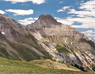
Potosi Peak is a 13,786-foot-elevation (4,202-meter) mountain summit located in Ouray County of Colorado, United States. It is situated five miles southwest of the community of Ouray, on land managed by Uncompahgre National Forest. It is part of the Sneffels Range which is a subset of the San Juan Mountains, which in turn is part of the Rocky Mountains. It is situated west of the Continental Divide, 2.2 miles south of Whitehouse Mountain, and 2.5 miles southeast of Mount Sneffels. Potosi ranks as the 113th-highest peak in Colorado, and the fourth-highest in the Sneffels Range. Recreation enthusiasts heading for Yankee Boy Basin traverse below the southern base of the mountain. Topographic relief is significant as the southeast aspect rises 4,000 feet above the Camp Bird Mine in approximately 1.5 mile. The mining activity in the immediate area produced significant amounts of gold and silver. "Potosi" in Quechuan language translates to "great wealth.". The mountain's name, which has been officially adopted by the United States Board on Geographic Names, was in use before 1899 when Henry Gannett published it in A Dictionary of Altitudes in the United States.
Washburn Mountain is a 1,496-foot-tall (456 m) mountain in New York. It is located south-southeast Copake Falls in Columbia County. From 1932 to 1964, the mountain was the location of a 60-foot-tall (18 m) steel fire lookout tower now located on Beebe Hill. Alander Mountain is located southeast of Washburn Mountain.

