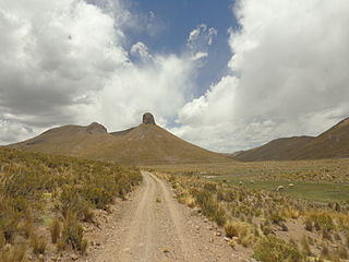
José Manuel Pando is a province in the La Paz Department in Bolivia. It was founded on April 22, 1986 during the presidency of Víctor Paz Estenssoro. The province was named after José Manuel Pando (1848-1917) who was the president of Bolivia from 1899 till 1904. Its capital is Santiago de Machaca.
Catacora Municipality is the second municipal section of the José Manuel Pando Province in the La Paz Department, Bolivia. Its seat is Catacora.

T'ula Qullu or Suri Qullu is a 4,842-metre-high (15,886 ft) mountain in the Andes of Bolivia. It is situated in the La Paz Department, José Manuel Pando Province, Catacora Municipality, T'ula Qullu Canton. T'ula Qullu lies near the border to Peru, between the Peruvian mountain Chila 5,184 m (17,008 ft) in the west and Sinijawi 5,068 m (16,627 ft) in the east, northwest of the Sirk'i volcano.

Quellhuacota is a mountain in the Vilcanota mountain range in the Andes of Peru, about 5,300 metres (17,388 ft) high. It is located in the Cusco Region, Canchis Province, San Pablo District, and in the Puno Region, Melgar Province, Nuñoa District. It is situated southwest of the mountains Jochajucho, Jatun Sallica and Wiqu, and northeast of the mountain Sampu.

Qillwiri is a mountain in the Andes on the border of Bolivia and Chile. On the Chilean side it is located in the Arica y Parinacota Region. It is situated in the Cordillera Occidental between the mountains Pukintika in the north-west and Lliscaya in the south-east, east of the Suriri salt flat. On the Bolivian side the mountain lies in the Oruro Department, Sabaya Province, Sabaya Municipality.

Wila Qullu is a 4,932-metre-high (16,181 ft) mountain in the Andes of Bolivia. It is situated in the La Paz Department, José Manuel Pando Province, Catacora Municipality. Wila Qullu lies north of the mountain Apachita, north-east of Chuqiwa Qullu (Chuquivakkollu) and south-east of Laram Q'awa.

Laram Q'awa is a 4,988-metre-high (16,365 ft) mountain in the Andes of Bolivia. It is situated in the La Paz Department, José Manuel Pando Province, Catacora Municipality. Laram Q'awa lies north-west of the mountains Apachita and Wila Qullu and north-east of Chuqiwa Qullu (Chuquivakkollu).

Apachita is a mountain in the Andes of Bolivia, about 4,800 metres (15,748 ft) high. It is situated in the La Paz Department, José Manuel Pando Province, Catacora Municipality. Apachita lies south of the mountain Wila Qullu, north-west of Ch'iyar Jaqhi and south-east of Laram Q'awa and Chuqiwa Qullu (Chuquivakkollu).

Ch'iyar Jaqhi is a mountain in the Andes of Bolivia, about 4,720 metres (15,486 ft) high. It is situated in the La Paz Department, José Manuel Pando Province, Catacora Municipality. Ch'iyar Jaqhi lies south-east of the mountains Laram Q'awa, Chuqiwa Qullu (Chuquivakkollu), Wila Qullu and Apachita and north-west of the Sirk'i volcano. It is situated at one of the affluents of the Ch'allipiña River (Challipiña).

Llallawa is a 4,530-metre-high (14,862 ft) mountain in the Andes of Bolivia. It is situated in the La Paz Department, José Manuel Pando Province, Santiago de Machaca Municipality. Llallawa lies north of Payrumani and northeast of Llallawa Nasa (Llallaguanasa). It is situated at one of the affluents of the Payrumani River.

Wari Kunka is a 5,120-metre-high (16,798 ft) mountain in the Andes of Bolivia. It is situated in the La Paz Department, José Manuel Pando Province, at the border of the Catacora Municipality and the Santiago de Machaca Municipality. Wari Kunka lies southeast of Patapatani, northeast of Sinijawi and southeast of Jisk'a Wari Kunka. An intermittent stream named Salla Uma originates southwest of the mountain. It flows to the west where it meets Jaruma River as a left tributary.

Qillwa Quta is a mountain in the eastern extensions of the Apolobamba mountain range in Bolivia, about 4,900 metres (16,076 ft) high. It is situated in the La Paz Department, Bautista Saavedra Province, Curva Municipality.

Qillwani is a 5,828-metre-high (19,121 ft) mountain in the Cordillera Real in the Andes of Bolivia. It is located in the La Paz Department, Larecaja Province, near the western border of the Guanay Municipality. It lies southeast of Ch'iyar Juqhu, northwest of Chachakumani and northeast of Patapatani.

Qillwan Quta is a 4,826-metre-high (15,833 ft) mountain in the Bolivian Andes. It is located in the La Paz Department, Loayza Province, Luribay Municipality. Qillwan Quta lies northwest of Chuqi Sillani at a plain named Qillwan Quta Pampa.

Misa Willk'i is a 5,098-metre-high (16,726 ft) mountain in the Andes of Bolivia. It is located in the La Paz Department, José Manuel Pando Province, at the border of the Catacora Municipality and the Santiago de Machaca Municipality. Misa Willk'i lies northeast of Sinijawi and southeast of Wari Kunka.

Jach'a Qiñwa Qullu is a mountain in the Andes of Bolivia which reaches a height of approximately 4,800 m (15,700 ft). It is located in the La Paz Department, José Manuel Pando Province, Catacora Municipality. Jach'a Qiñwa Qullu lies north of the Jaruma River, east of Ch'alla Willk'i.

Janq'u Qullu is a mountain in the Andes of Bolivia which reaches a height of approximately 4,660 m (15,290 ft). It is located in the La Paz Department, José Manuel Pando Province, Catacora Municipality. The Janq'u Qullu River which originates southwest of the mountain flows along its slopes.

Wila Willk'i is a 4,286-metre-high (14,062 ft) mountain in the Andes of Bolivia. It is located at the Peruvian border in the La Paz Department, José Manuel Pando Province, Catacora Municipality, southwest of T'ula Qullu.

Qiwñuyu is a 4,428-metre-high (14,528 ft) mountain in the Andes of Bolivia. It is situated in the La Paz Department, José Manuel Pando Province, Catacora Municipality. The Junt'uni Jawira originates at the mountain. It flows to the southeast.

Qiñwani is a mountain in the Andes of Bolivia which reaches a height of approximately 4,380 m (14,370 ft). It is situated in the La Paz Department, José Manuel Pando Province, Catacora Municipality. Qiñwani lies at the Peruvian border, west of the Junt'uni Jawira.


