
Punjab, also known as the Land of the Five Rivers, is a geopolitical, cultural, and historical region in South Asia. It is specifically located in the northwestern part of the Indian subcontinent, comprising areas of modern-day eastern-Pakistan and northwestern-India. Punjab's major cities are Lahore, Faisalabad, Rawalpindi, Gujranwala, Multan, Ludhiana, Amritsar, Sialkot, Chandigarh, Shimla, Jalandhar, Patiala, Gurugram, and Bahawalpur.

India is a federal union comprising 28 states and 8 union territories, for a total of 36 entities. The states and union territories are further subdivided into 785 districts and smaller administrative divisions.

State Bank of India (SBI) is an Indian multinational public sector bank and financial services statutory body headquartered in Mumbai, Maharashtra. It is the 47th largest bank in the world by total assets and ranked 221st in the Fortune Global 500 list of the world's biggest corporations of 2020, being the only Indian bank on the list. It is a public sector bank and the largest bank in India with a 23% market share by assets and a 25% share of the total loan and deposits market. It is also the tenth largest employer in India with nearly 250,000 employees. In 2023, the company’s seat in Forbes Global 2000 was 77.
The Patiala and East Punjab States Union (PEPSU) was a state of India, uniting eight princely states between 1948 and 1956. The capital and principal city was Patiala. The state covered an area of 26,208 km2. Shimla, Kasauli, Kandaghat and Chail also became part of PEPSU.

The Punjab Regiment is the second oldest regiment still in service in the Indian Army, and is the most senior regional infantry regiment. It was formed from the 2nd Punjab Regiment of the British Indian Army in 1947 and has taken part in various battles and wars since, winning numerous honours for the same.

The Cis-Sutlej states were a group of states in the contemporary Punjab and Haryana states of northern India during the 19th century, lying between the Sutlej River on the north, the Himalayas on the east, the Yamuna River and Delhi District on the south, and Sirsa District on the west. The small Punjabi kingdoms of the Cis-Sutlej states paid tributes to the Marathas, until the Second Anglo-Maratha War of 1803–1805, after which the Marathas lost this territory to the British.

The Punjab Province was a province of British India. Most of the Punjab region was annexed by the British East India Company on 29 March 1849; it was one of the last areas of the Indian subcontinent to fall under British control. In 1858, the Punjab, along with the rest of British India, came under the rule of the British Crown. It had a land area of 358,355 square kilometers.
Charkhi Dadri is a city and the headquarters of Charkhi Dadri district in the Indian state of Haryana, about 90 km from the national capital Delhi. The town was made by joining the villages of Charkhi and Dadri after urban development. Charkhi Dadri is on NH 148B between Narnaul to Bathinda and NH 348B between Meerut to Pilani segment passing through the city.

East Punjab was a province of India from 1947 until 1950. It consisted parts of the Punjab province that remained in India following the partition of the province between the new dominions of Pakistan and the Indian Union by the Radcliffe Commission in 1947. The mostly Muslim western parts of the old Punjab became Pakistan's West Punjab, later renamed as Punjab Province, while the mostly Hindu and Sikh eastern parts remained with India.
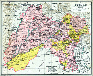
The Punjab States Agency was an agency of the British Raj. The agency was created in 1921, on the model of the Central India Agency and Rajputana Agency, and dealt with forty princely states in northwest India formerly dealt with by the Province of Punjab.
Malaudh was a Cis-Sutlej Phulkian princely state of India till 1846, after which it was merged into the Ludhiana District by the British when they annexed the territories around Ludhiana. The town of Malaudh, or Maloud, is situated at a distance of about 40 kilometres from Ludhiana on the Ludhiana-Malerkotla Road and is linked by approach road kup-payal road though village Rorian which is now part of it as Nagar Panchayat. It lies on 75°- 56' Longitude and 30° – 38' Latitude. Malaudh is a very ancient place which was known as Malla Udey or rise of the Mallas with whom Multan or Mallustan is associated and later got corrupted to Malaudh. There was a The Loharan about 1 kilometer on the southern side which has now disappeared. Malaudh has a government high school (co-educational), middle school for girls and a primary school for boys, a post office, primary health centre and a veterinary dispensary. Malaudh became a part of the Ludhiana District when it was formed out of the territories annexed by the British in 1846.

The Phulkian Dynasty of Maharajas or sardars were Sikh rulers and aristocrats in the Punjab region of India. They governed the states of Faridkot, Jind, Nabha, Malaudh, Bhadaur, Badrukhan and Patiala, allying themselves with the British Raj as per the Cis-Sutlej treaty. Members of the Phulkian dynasty, who are the direct descendants of Rawal Jaisal, the founder of Jaisalmer, migrated to the present-day Malwa region in Punjab.

Nabha State, with its capital at Nabha, was one of the Phulkian princely states of Punjab during the British Raj in India. Nabha was ruled by Jat Sikhs of the Sidhu clan.
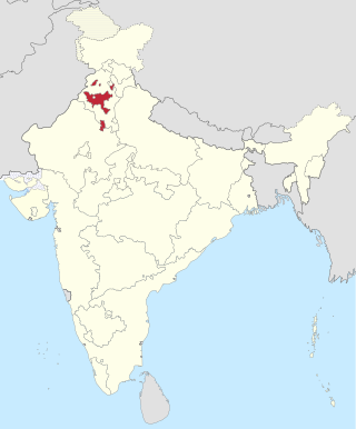
Punjab is home to 2.3% of India's population; with a density of 551 persons per km2. According to the provisional results of the 2011 national census, Punjab has a population of 27,743,338, making it the 16th most populated state in India. Of which male and female are 14,639,465 and 13,103,873 respectively. 32% of Punjab's population consists of Dalits. In the state, the rate of population growth is 13.9% (2011), lower than national average. Out of total population, 37.5% people live in urban regions. The total figure of population living in urban areas is 10,399,146 of which 5,545,989 are males and while remaining 4,853,157 are females. The urban population in the last 10 years has increased by 37.5%. According to the 2011 Census of India, Punjab, India has a population of around 27.7 million.
Religion in the Punjab in ancient history was characterized by Hinduism and later conversions to Jainism, Buddhism, Islam, Sikhism and Christianity; it also includes folk practices common to all Punjabis regardless of the religion they adhere to. Such practices incorporate local mysticism, including ancestral worship and worship of local saints of all faiths.

The Post Office of India of the British Raj entered into postal conventions with a few native states of India. As per the postal convention, existing adhesive stamps and postal stationery of British India were overprinted with the name of the state for use within each convention State, for mail from one convention state to another, and to destinations in British India. The state administrations, in turn, had to conform to a number of agreements covering the issuance of stamps, the rates of postage, and the exchange of mail.

Jind State was a princely state located in the Punjab region of north-western India. The state was 3,260 km2 (1,260 sq mi) in area and its annual income was Rs.3,000,000 in the 1940s. Jind was founded and ruled by Jat Sikh rulers of Sidhu clan.
The Warya is a Rajput clan found predominantly in the Punjab and Sindh provinces of Pakistan and in the state of Gujarat in India.

Loharu State was one of the princely states of India during the period of the British Raj. It was part of the Punjab States Agency and was a nine-gun salute state.

Phulkian Misl was a Sikh misl named after Choudhary Phul Singh.