Taff's Well
| |
---|---|
![]() | |
Location within Rhondda Cynon Taf | |
Population | 3,672 (2011) [1] |
OS grid reference | ST121834 |
Community |
|
Principal area | |
Preserved county | |
Country | Wales |
Sovereign state | United Kingdom |
Post town | CARDIFF |
Postcode district | CF15 |
Dialling code | 029 |
Police | South Wales |
Fire | South Wales |
Ambulance | Welsh |
UK Parliament | |
Senedd Cymru – Welsh Parliament | |
Taff's Well (Welsh : Ffynnon Taf) is a semi-rural village, community and electoral ward located at the south-eastern tip of Rhondda Cynon Taf, 6 miles (9.7 km) to the north of Cardiff, the capital city of Wales. Known locally as the 'Gates to the Valleys' by some and considered part of the Valleys by others, it is separated from Gwaelod-y-Garth by the River Taff. Taff's Well is distinguished because it contains the only thermal spring in Wales. The tepid water is thought to rise along a fault-line from the Carboniferous Limestone, in somewhat similar manner to the warm springs at Bristol and Bath. The Welsh myth of the Taff's Well Turtle originates here. Various religious groups regard it as a spiritual site. [3]
Garth Hill overlooks the village and was the inspiration for the fictional "Ffynnon Garw", featured in the book and film The Englishman Who Went up a Hill but Came down a Mountain .
The name "Taff's Well" is derived from the situation of the village alongside the River Taff and the presence of the warm spring within Taff's Well Park.
Taff's Well Park (Parc Ffynnon Taf) is the site of the Taff's Well Thermal Spring, a well that reached its height of popularity for visitors to the village in the mid to late 1800s. [4] The average temperature of the water is 21.6 degrees C. [5] The well is Wales' only natural thermal spa.
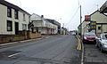
Taff's Well lies just off Junction 32 of the M4 motorway and at the southern end of the A470.
Though administered by Rhondda Cynon Taff Council, Taff's Well is a commuter town for the City of Cardiff, where many of its residents work.
Taff's Well grew into an important railway junction during the mid- to late 19th century, when Cardiff was a major global exporter of coal.
Taff's Well is a growing community which includes numerous districts: Glan-y-Llyn, Rhiw Ddar and Glan-y-Fordd; Ty-Rhillage centre that consists of Alfred's terrace, Anchor Street, Church Street, Garth Street, Yew Street and Ty Rhiw through which the Taff Trail runs. Taff's Well is next to Castell Coch, which overlooks Cardiff.
The actor David Jason spent much time in Taff's Well and based the situation comedy Open All Hours upon Arthur's shop, [6] which is one of many buildings to have been dismantled and sent to the St Fagan's Museum of Welsh Life.
Taff's Well is the original location of the story that inspired the film The Englishman Who Went up a Hill but Came down a Mountain , by Ivor Monger and Christopher Monger.
Taff's Well has featured in the Sky sitcom Stella, starring Ruth Jones. The post office in Nantgarw is a filming location in the sitcom, although it is just outside the village.
Taff's Well is an electoral ward coterminous to the community boundaries and elects a county councillor to Rhondda Cynon Taf County Borough Council. Jill Bonetto (Labour) has represented the ward since 2012. [7] [8]
Taff's Well and Nantgarw are also represented locally by the Taff's Well & Nantgarw Community Council, which has 10 members. The Council was criticised in 2010 by the Wales Audit Office for breaching financial and corporate governance regulations with its financial records. Described as 'The worst-run council in Wales', there were calls for the 'wholesale sacking' of the ten members for breaching 'financial and corporate governance regulations because of its "inadequate" financial records, supporting paperwork and minutes between 2002 and 2006'. [9]
Taff's Well A.F.C. are the local football team. They play in the Cymru South, the second tier of the Welsh football league system.
Taffs Well RFC are the local Rugby union team.
Taffs Well railway station, which opened in 1863, [10] is on the Rhondda and Merthyr Lines. Services are provided by Transport for Wales northbound to Treherbert, Aberdare and Merthyr Tydfil via Pontypridd, and southbound to Cardiff Queen Street and Cardiff Central. The average journey time to Cardiff Central is 20 minutes at a frequency of six trains per hour. [11]
Stagecoach South Wales bus service 132 between Maerdy and Cardiff Central bus station stops in the village every 15 minutes at peak times. [12]
The A470 road runs through the village between Cardiff Bay (9 miles (14 km) south) and Llandudno (179 miles (288 km) north). Taff's Well is 2 miles (3.2 km) north of junction 32 (Cardiff North) of the M4 motorway.
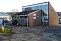
There are plans to integrate Taff's Well into the South Wales Metro.[ citation needed ]
The former Walnut Tree Viaduct ran across the Taff Valley to the south of Taff's Well. Two of the support columns remain standing.
Taff's Well has two active churches:
Like the neighbouring community of Tongwynlais, Taff's Well formerly had a number of other churches which have ceased to function and have either been converted to other purposes or been demolished:
Ty Rhiw cemetery in Taff's Well was one of several cemeteries in Rhondda Cynon Taf where bodies were buried in the wrong graves. The errors were discovered in the early 2000s and resulted in a police investigation. [21] In 2009, Taffs Well and Nantgarw Community Council planned to reuse the chapel at the cemetery for weddings and funerals, as was originally intended. A campaign against the decision was led by the Friends of Ty Rhiw Cemetery. [22] There are seven Commonwealth War Graves Commission memorials in the cemetery, marking the burial place of British sailors and soldiers from the First and Second World Wars. [23]
Pontypridd, colloquially referred to as Ponty, is a town and a community in Rhondda Cynon Taf, South Wales, approximately 10 miles north west of Cardiff city centre.
Rhondda Cynon Taf is a county borough in the south-east of Wales. It consists of five valleys: the Rhondda Fawr, Rhondda Fach, Cynon, Taff and Ely valleys, plus several towns and villages away from the valleys.
Mountain Ash is a town and former community in the Cynon Valley, within the County Borough of Rhondda Cynon Taf, Wales, with a population of 11,230 at the 2011 Census, estimated in 2019 at 11,339. It includes the districts and villages of Cefnpennar, Cwmpennar, Caegarw, Darranlas, Fernhill, Glenboi and Newtown, all within the historic county boundaries of Glamorgan. Aberdare lies about 4.5 miles (7.2 km) north-west, Cardiff 19 miles (31 km) south-east, and Penrhiwceiber a mile to the south-east. It divides into two communities : West covers the town centre and the districts of Miskin, Darranlas, Fernhill and Glenboi, and East the districts of Cefnpennar, Cwmpennar, Caegarw and Newtown.
Treforest is a village in the south-east of Pontypridd, in the county borough of Rhondda Cynon Taf, Wales. It is situated in the Treforest electoral ward, along with the village of Glyntaff. It is part of the Pontypridd Town community. Treforest runs along the west bank of the River Taff, while Glyntaff runs along its east bank.
Abercynon is a village and community in the Cynon Valley within the unitary authority of Rhondda Cynon Taf, Wales. The community comprises the village and the districts of Carnetown and Grovers Field to the south, Navigation Park to the east, and Glancynon to the north.
Ynyshir is a village and community located in the Rhondda Valley, within Rhondda Cynon Taf, South Wales. The name of the village means "long island" in Welsh and takes its name from a farm in the area, falling within the historic parishes of Ystradyfodwg and Llanwynno (Llanwonno). The community of Ynyshir lies between the small adjoining village of Wattstown and the larger town of neighbouring Porth.
Ferndale is a town and community located in the Rhondda Valley in the county borough of Rhondda Cynon Taf, Wales. Neighbouring villages are Blaenllechau, Maerdy and Tylorstown. Ferndale was industrialised in the mid-19th century. The first coal mine shaft was sunk in 1857 and Ferndale was the first community to be intensively industrialised in the Rhondda Valley.
The Diocese of Llandaff is an Anglican diocese that traces its roots to pre-Reformation times as heir of a Catholic bishopric. It is headed by the Bishop of Llandaff, whose seat is located at the Cathedral Church of Saint Peter and Saint Paul in Llandaff, a suburb of Cardiff. It currently covers most of the former Welsh county of Glamorgan, but once stretched from the River Towy to the middle of the Wye Valley.
Penrhiwceiber is a small Welsh village and community in the county borough of Rhondda Cynon Taf that lies south of the town Aberpennar and north of the village of Tyntetown, and is one of many villages that lies within the Cynon Valley. Prior to 1870 the area was heavy woodland, but the opening of the Penrhiwceiber Colliery in 1878 saw its rapid expansion into a thriving village.
Upper Boat is a village on the southernmost outskirts of the town of Pontypridd, within the electoral ward of Hawthorn, Rhondda Cynon Taf, Wales, and comprises part of the Treforest Industrial Estate. Historically part of Glamorgan, it fell within the parish of Eglwysilan.
Cymmer is a village and community in the Rhondda Valley, Wales. It is so named because of being located at the 'confluence' of the Rhondda Fawr and Rhondda Fach river valleys. Several collieries were opened here in the middle part of the nineteenth century. A coal mine disaster in 1856 resulted in 114 casualties, and the lack of payment of any compensation to the miners' families caused bitter feelings in the community.
Church Village is a large village in the historic parish and community of Llantwit Fardre, located within the Taff Ely district of the County Borough of Rhondda Cynon Taf in Wales. The village is centrally located being around 4 miles (6.4 km) from the local principal towns of Llantrisant to the southwest and Pontypridd to the north and is situated approximately 8 miles northwest of Cardiff city centre.
Tonteg is a village in Rhondda Cynon Taf in South Wales. It is 4 miles (6.4 km) from Pontypridd, 9 miles (14.5 km) north west of Cardiff and 4 miles (6.44 km) north east of Llantrisant. The village is within the community of Llantwit Fardre. Tonteg is to the north west of the Garth Mountain, on the west side of the River Taff valley, at the top of a hill known locally as Powerstation Hill. The hill gets its name from the Upper Boat power station which was situated at the bottom of the hill until it was demolished in 1972. Tonteg is next to Church Village and the boundaries between the two villages are blurred. A significant part of the Treforest Industrial Estate falls within the Willowford area of Tonteg.
Afon Clun is a 14-mile (23 km) long tributary of the River Ely, in the counties of Cardiff and Rhondda Cynon Taf, Wales. Its bedrock is predominantly of sandstone. Beginning on the western slope of The Garth the river is fast-flowing, in clear shallow water with a hard substrate, flowing to the south of Llantrisant and generally west to its confluence with the River Ely at Pontyclun, falling 715 feet (218 m) over its course.
Ynysboeth is a suburban area in the community of Abercynon, in the Cynon Valley, Rhondda Cynon Taf, South East Wales.
Penderyn is a rural village in the Cynon Valley, Rhondda Cynon Taf, Wales, located near Hirwaun.
Rhondda Cynon Taf is a county borough in South Wales. It is located to the north-west of Cardiff and covers an area of 424 km2 (164 sq mi). In 2021 the population was approximately 237,500.
St Michael and All Angels Church is an Anglican church in the village of Tongwynlais, South Wales, serving the parish of the same name. It is a Grade II listed building.
Rhondda Cynon Taf is a county borough in South Wales. It is located to the north-west of Cardiff and covers an area of 424 km2 (164 sq mi). In 2021 the population was approximately 237,500.