
Kingston upon Hull, usually abbreviated to Hull, is a port city and unitary authority in the East Riding of Yorkshire, England. It lies upon the River Hull at its confluence with the Humber Estuary, 25 miles (40 km) inland from the North Sea, 50 miles (80 km) east of Leeds, 34 miles (55 km) south-east of York and 54 miles (87 km) north-east of Sheffield. With a population of 259,778 (mid-2019 est.), Hull is the fourth-largest city in the Yorkshire and the Humber region.

The East Riding of Yorkshire, or simply East Riding or East Yorkshire, is a county in Northern England. The name is traditionally and geographically a reference to the easternmost of the three subdivisions of the traditional county of Yorkshire. The boundaries of the East Riding, the North Riding and the West Riding were historically treated as three separate areas for many cultural and legal purposes, such as having separate quarter sessions. In 1889 under the Local Government Act 1888, administrative counties were formed on the existing historic county boundaries in England, but in Yorkshire, given the vast size of the county area, three administrative county councils were created, based on the historic boundaries of the three Ridings. The East Riding County Council was the administrative local government and ceremonial county (Lieutenancy) area established for the area ; it remained in place for eighty-six years until being removed for new administrative tiers of local government.
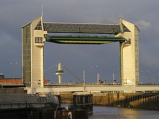
The River Hull is a navigable river in the East Riding of Yorkshire in Northern England. It rises from a series of springs to the west of Driffield, and enters the Humber Estuary at Kingston upon Hull. Following a period when the Archbishops of York charged tolls for its use, it became a free navigation. The upper reaches became part of the Driffield Navigation from 1770, after which they were again subject to tolls, and the section within the city of Hull came under the jurisdiction of the Port of Hull, with the same result.

Goole is a town, civil parish and inland port in the East Riding of Yorkshire, England. The town was historically within the West Riding of Yorkshire. Goole lies 19 miles (31 km) south of York and 29 miles (47 km) west of Hull.

The A63 is a major road in Yorkshire, England between Leeds and Kingston upon Hull. A section between North Cave and Hull forms the eastward continuation of the M62 motorway and is part of the unsigned Euroroute E20.

Hedon is a town and civil parish in Holderness in the East Riding of Yorkshire, England. It is situated approximately 5 miles (8 km) east of Hull city centre. It lies to the north of the A1033 road at the crossroads of the B1240 and B1362 roads. It is particularly noted for the parish church of St. Augustine, known as the 'King of Holderness', which is a Grade I listed building.

The Hull Barnsley & West Riding Junction Railway and Dock Company (HB&WRJR&DCo.) was opened on 20 July 1885. It had a total projected length of 66 miles but never reached Barnsley, stopping a few miles short at Stairfoot. The name was changed to The Hull and Barnsley Railway (H&BR) in 1905. Its Alexandra Dock in Hull opened 16 July 1885.

Paull is a village and civil parish in Holderness, in the East Riding of Yorkshire, England, lying on the north bank of the Humber Estuary, east of the watercourse known as Hedon Haven.

Cuthbert Brodrick FRIBA was a British architect, whose most famous building is Leeds Town Hall.

The Port of Hull is a port at the confluence of the River Hull and the Humber Estuary in Kingston upon Hull, in the East Riding of Yorkshire, England.

The A1033 road is a main arterial route across Kingston upon Hull and the East Riding of Yorkshire connecting Hull with Withernsea. The road carries traffic to and from the Port of Hull and Salt End at its western end, and local and holiday traffic at its eastern end. It is a primary route from the junction of the A63 road to the Salt End roundabout and is maintained on that section by Highways England. The section by the docks is also part of a designated abnormal load route.
The East Riding of Yorkshire is a local government district with unitary authority status, and is a ceremonial county of England. It is named after the historic East Riding of Yorkshire which was one of three ridings alongside the North Riding and West Riding, which were constituent parts a Yorkshire ceremonial and administrative county until 1974. From 1974 to 1996 the area of the modern East Riding of Yorkshire constituted the northern part of Humberside.
Marfleet is an area of Kingston upon Hull, East Riding of Yorkshire, England, in the east of the city, near King George Dock.
White's Directories were a series of directory publications issued by William White of Sheffield, England, beginning in the 1820s. White began his career in publishing by working for Edward Baines.
The following is a timeline of the history of the city of Bradford, West Yorkshire, England.
The following is a timeline of the history of the city of Southampton, Hampshire, England.
Lime Kiln Creek was an outlet onto the Humber Estuary in Kingston upon Hull, England, thought to be a previous outlet of the River Hull onto the estuary. It was blocked off during the construction of the Albert Dock in the 1860s.
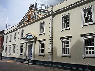
The Hull Trinity House, locally known as Trinity House, is a seafaring organisation consisting of a charity for seafarers, a school, and a guild of mariners. The guild originated as a religious guild providing support and almshouses for the needy, and established a school for mariners in 1787. By the 18th century it had responsibilities including management of the harbour at Hull, and buoys and pilotage in the Humber Estuary.
Dairycoates is an area of Kingston upon Hull, East Riding of Yorkshire, England, a former hamlet.

Hedon Haven is a waterway that connected the Humber Estuary with the port of Hedon, in Holderness, East Riding of Yorkshire, England. The waterway allowed ships to unload at the port in Hedon, which was also known as Hedon Haven and had, at its peak, three canalised arms that stretched into the town. The port at Hedon was the main port for south Holderness between the 12th and 13th centuries, and was the busiest port in Holderness before the docks at Hull were built.

