Topography of Croatia

Last updated

Topographic map of Croatia Croatia topo.jpg
Topographic map of Croatia

Topography of Croatia is defined through three major geomorphological parts of the country. Those are the Pannonian Basin, the Dinaric Alps, and the Adriatic Basin. The largest part of Croatia consists of lowlands, with elevations of less than 200 metres (660 feet) above sea level recorded in 53.42% of the country. Bulk of the lowlands are found in the northern regions of the country, especially in Slavonia, itself a part of the Pannonian Basin plain. The plains are interspersed by the horst and graben structures, believed to break the Pannonian Sea surface as islands. The greatest concentration of ground at relatively high elevations is found in Lika and Gorski Kotar areas in the Dinaric Alps, but such areas are found in all regions of Croatia to some extent. The Dinaric Alps contain the highest mountain in Croatia—1,831-metre (6,007 ft) Dinara, as well as all other mountains in Croatia higher than 1,500 metres (4,900 feet). Croatia's Adriatic Sea mainland coast is 1,777.3 kilometres (1,104.4 miles) long, while its 1,246 islands and islets encompass further 4,058 kilometres (2,522 miles) of coastline—the most indented coastline in the Mediterranean. Karst topography makes up about half of Croatia and is especially prominent in the Dinaric Alps, as well as throughout the coastal areas and the islands.

Contents

Geomorphological units

The largest part of Croatia consists of lowlands, with elevations of less than 200 metres (660 feet) above sea level recorded in 53.42% of the country. Bulk of the lowlands are found in the northern regions of the country, especially in Slavonia, representing a part of the Pannonian Basin. Territory with elevations of 200 to 500 metres (660 to 1,640 feet) above sea level encompasses 25.61% of Croatia's territory, and the areas between 500 and 1,000 metres (1,600 and 3,300 feet) above sea level cover the 17.11% of the country. Further 3.71% of the land is situated at 1,000 to 1,500 metres (3,300 to 4,900 feet) above sea level, and only 0.15% of Croatia's territory lies at elevations greater than 1,500 metres (4,900 feet) above sea level. [1] The greatest concentration of ground at relatively high elevations is found in Lika and Gorski Kotar areas in the Dinaric Alps, but such areas are found in all regions of Croatia to some extent. [2] The Pannonian Basin and the Dinaric Alps, along with the Adriatic Basin represent major geomorphological parts of Croatia. [3]

Adriatic Basin

Kornati national park Kornati islands.jpg
Kornati national park

Croatia's Adriatic Sea mainland coast is 1,777.3 kilometres (1,104.4 miles) long, while its 1,246 islands and islets encompass further 4,058 kilometres (2,522 miles) of coastline. The distance between the extreme points of Croatia's coastline is 526 kilometres (327 miles). [4] The number of islands includes all islands, islets, and rocks of all sizes, including ones emerging at ebb tide only. [5] The islands include the largest ones in the Adriatic—Cres and Krk, each covering 405.78 square kilometres (156.67 square miles), and the tallest—Brač, whose peak reaches 780 metres (2,560 feet) above sea level. The islands include 48 permanently inhabited ones, the most populous among them being Krk and Korčula. [1]

The shore is the most indented coastline in the Mediterranean. [6] The majority of the coast is characterised by a karst topography, developed from the Adriatic Carbonate Platform. Karstification there largely began after the final uplift of the Dinarides in the Oligocene and the Miocene, when carbonate deposits were exposed to atmospheric effects, extending to the level of 120 metres (390 feet) below present sea level, exposed during the Last Glacial Maximum. It is estimated that some karst formations are related to earlier immersions, most notably the Messinian salinity crisis. [7] The largest part of the eastern coast consists of carbonate rocks, while flysch is significantly represented in the Gulf of Trieste coast, on the Kvarner Gulf coast opposite Krk, and in Dalmatia north of Split. [8] There are comparably small alluvial areas of the Adriatic coast in Croatia—most notably the Neretva Delta. [9] The western Istria is gradually subsiding, having sunk about 1.5 metres (4 feet 11 inches) in the past two thousand years. [10] In the Middle Adriatic Basin, there is evidence of Permian volcanism observed in area of Komiža on the island of Vis and as volcanic islands of Jabuka and Brusnik. [11]

Dinaric Alps

Dinara seen from Knin Dinara Knin Croatia.jpg
Dinara seen from Knin

Formation of the Dinaric Alps is linked to a Late Jurassic to recent fold and thrust belt, itself a part of Alpine orogeny, extending southeast from the southern Alps. [12] The Dinaric Alps in Croatia encompass the entire Gorski Kotar and Lika regions, as well as considerable parts of Dalmatia, with their northeastern edge running from 1,181-metre (3,875 ft) Žumberak to Banovina region, along the Sava River, [13] and their westernmost landforms being 1,272-metre (4,173 ft) Ćićarija and 1,396-metre (4,580 ft) Učka mountains in Istria. The Dinaric Alps contain the highest mountain in Croatia—1,831-metre (6,007 ft) Dinara, as well as all other mountains in Croatia higher than 1,500 metres (4,900 feet)Biokovo, Velebit, Plješivica, Velika Kapela, Risnjak, Svilaja and Snježnik. [1]

Karst topography makes up about half of Croatia and is especially prominent in the Dinaric Alps. [14] There are numerous caves in Croatia, 49 of which deeper than 250 metres (820.21 feet), 14 deeper than 500 metres (1,640.42 feet) and three deeper than 1,000 metres (3,280.84 feet). [15] The longest cave in Croatia, Kita Gaćešina, is at the same time the longest cave in the Dinaric Alps at 37,389 metres (122,667 feet). [16]

Highest mountain peaks of Croatia [1]
MountainPeakElevationCoordinates
Dinara Dinara1,831 m (6,007 ft) 44°3′N16°23′E / 44.050°N 16.383°E / 44.050; 16.383
Biokovo Sveti Jure1,762 m (5,781 ft) 43°20′N17°03′E / 43.333°N 17.050°E / 43.333; 17.050
Velebit Vaganski vrh1,757 m (5,764 ft) 44°32′N15°14′E / 44.533°N 15.233°E / 44.533; 15.233
Plješivica Ozeblin1,657 m (5,436 ft) 44°47′N15°45′E / 44.783°N 15.750°E / 44.783; 15.750
Velika Kapela Bjelolasica   Kula1,533 m (5,030 ft) 45°16′N14°58′E / 45.267°N 14.967°E / 45.267; 14.967
Risnjak Risnjak1,528 m (5,013 ft) 45°25′N14°45′E / 45.417°N 14.750°E / 45.417; 14.750
Svilaja Svilaja1,508 m (4,948 ft) 43°49′N16°27′E / 43.817°N 16.450°E / 43.817; 16.450
Snježnik Snježnik1,506 m (4,941 ft) 45°26′N14°35′E / 45.433°N 14.583°E / 45.433; 14.583

Pannonian Basin

A plain in Slavonia Tree in the sun.jpg
A plain in Slavonia

The Pannonian Basin took shape through Miocenian thinning and subsidence of crust structures formed during Late Paleozoic Variscan orogeny. The Paleozoic and Mesozoic structures are visible in Papuk and other Slavonian mountains. The processes also led to formation of a stratovolcanic chain in the basin 17  12  Mya and intensified subsidence observed until 5 Mya as well as flood basalts about 7.5 Mya. Contemporary uplift of the Carpathian Mountains severed water flow to the Black Sea and Pannonian Sea formed in the basin. Sediment were transported to the basin from uplifting Carpathian and Dinaric mountains, with particularly deep fluvial sediments being deposited in the Pleistocene during uplift of the Transdanubian Mountains. [17] Ultimately, up to 3,000 metres (9,800 feet) of the sediment was deposited in the basin, and the sea eventually drained through the Iron Gate gorge. [18]

The results of those processes are large plains in the eastern Slavonia, Baranya and Syrmia, as well as in river valleys, especially along Sava, Drava and Kupa. The plains are interspersed by the horst and graben structures, believed to break the Pannonian Sea surface as islands.[ citation needed ] The tallest among such landforms are 1,059-metre (3,474 ft) Ivanšćica and 1,035-metre (3,396 ft) Medvednica north of Zagreb and in Hrvatsko Zagorje as well as 984-metre (3,228 ft) Psunj and 953-metre (3,127 ft) Papuk which are the tallest among the Slavonian mountains surrounding Požega. [1] Psunj, Papuk and adjacent Krndija consist mostly of Paleozoic rocks which are 350  300 million years old. Požeška gora, adjacent to Psunj, consists of much more recent Neogene rocks, but there are also Upper Cretaceous sediments and igneous rocks forming the main, 30-kilometre (19 mi) ridge of the hill and representing the largest igneous landform in Croatia. A smaller igneous landform is also present on Papuk, near Voćin. [19] The two, as well as Moslavačka gora are possible remnants of a volcanic arc related to uplifting of the Dinaric Alps. [12]

See also

Related Research Articles

<span class="mw-page-title-main">Geography of Croatia</span> Geographic features of Croatia

The geography of Croatia is defined by its location—it is described as located at the crossroads of Central Europe and Southeast Europe, a part of the Balkans and Southern Europe. Croatia's territory covers 56,594 km2 (21,851 sq mi), making it the 127th largest country in the world. Bordered by Slovenia in the northwest, Hungary in the northeast, Bosnia and Herzegovina and Serbia in the east, Montenegro in the southeast and the Adriatic Sea in the south, it lies mostly between latitudes 42° and 47° N and longitudes 13° and 20° E. Croatia's territorial waters encompass 18,981 square kilometres (7,329 sq mi) in a 12 nautical miles wide zone, and its internal waters located within the baseline cover an additional 12,498 square kilometres (4,826 sq mi).

<span class="mw-page-title-main">Geography of Albania</span>

Albania is a country in Southeastern Europe that lies along the Adriatic and Ionian Seas, with a coastline spanning approximately 476 km (296 mi). Situated on the Balkan Peninsula, it is one of the most mountainous countries in Europe. It is bounded by Montenegro to the northwest, Kosovo to the northeast, North Macedonia to the east and Greece to the southeast and south.

<span class="mw-page-title-main">Geography of Italy</span> Geographical features of Italy

The geography of Italy includes the description of all the physical geographical elements of Italy. Italy, whose territory largely coincides with the homonymous geographical region, is located in southern Europe and comprises the long, boot-shaped Italian Peninsula crossed by the Apennines, the southern side of Alps, the large plain of the Po Valley and some islands including Sicily and Sardinia. Italy is part of the Northern Hemisphere. Two of the Pelagie Islands are located on the African continent.

<span class="mw-page-title-main">Geography of Slovenia</span>

Slovenia is situated at the crossroads of central and southeast Europe, touching the Alps and bordering the Adriatic Sea. The Alps—including the Julian Alps, the Kamnik–Savinja Alps and the Karawank chain, as well as the Pohorje massif—dominate northern Slovenia along its long border to Austria. Slovenia's Adriatic coastline stretches approximately 47 km (29 mi) from Italy to Croatia. Its part south of Sava river belongs to Balkan peninsula – Balkans.

<span class="mw-page-title-main">Dinaric Alps</span> Mountain range in the Balkan Peninsula of Southeastern Europe

The Dinaric Alps, also Dinarides, are a mountain range in Southern and Southcentral Europe, separating the continental Balkan Peninsula from the Adriatic Sea. They stretch from Italy in the northwest through Slovenia, Croatia, Bosnia and Herzegovina, Serbia, Montenegro, and Kosovo to Albania in the southeast.

<span class="mw-page-title-main">Sava</span> River in Central Europe

The Sava is a river in Central and Southeast Europe, a right-bank and the longest tributary of the Danube. It flows through Slovenia, Croatia and along its border with Bosnia and Herzegovina, and finally through Serbia, feeding into the Danube in its capital, Belgrade. The Sava forms the main northern limit of the Balkan Peninsula, and the southern edge of the Pannonian Plain.

<span class="mw-page-title-main">Pannonian Sea</span> Shallow ancient sea where the Pannonian Basin in Central Europe is today

The Pannonian Sea was a shallow ancient sea, where the Pannonian Basin in Central Europe is now. During its history it lost its connections with the neighbouring seas and became a lake. The Pannonian Sea existed from about 10 Ma until 1 Ma, during the Miocene and Pliocene epochs, when marine sediments were deposited to a depth of 3–4 km (1.9–2.5 mi) in the Pannonian Basin.

<span class="mw-page-title-main">Sognefjord</span> Fjord in Norway

The Sognefjord or Sognefjorden, nicknamed the King of the Fjords, is the largest and deepest fjord in Norway. Located in Vestland county in Western Norway, it stretches 205 kilometres (127 mi) inland from the ocean to the small village of Skjolden in the municipality of Luster.

<span class="mw-page-title-main">Cetina</span> River in Croatia

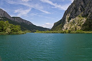
Cetina is a river in southern Croatia. It has a length of 101 km (63 mi) and its basin covers an area of 1,463 km2 (565 sq mi). From its source, Cetina descends from an elevation of 385 metres (1,263 ft) above sea level to the Adriatic Sea. It is the most water-rich river in Dalmatia.

<span class="mw-page-title-main">Kamešnica (mountain)</span> Mountain in Croatia and Bosnia and Herzegovina

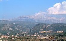
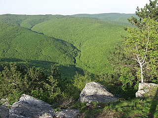
Kamešnica is a mountain in the Dinarides, located in the southern end of the Dinara Mountain Range on the border between Bosnia and Herzegovina and Croatia (Dalmatia). It is 1,851 metres (6,073 ft) tall and stretches from the northwest white road pass Vaganj (1173 m) to the Buško Blato artificial lake. The tallest peak is Konj (Horse) 1,855 metres (6,086 ft), which is located in Bosnia and Herzegovina and offer views of both sides of the border. In clear weather, it is possible to see the most remote areas of the Adriatic Sea and its islands. The vicinity's many trails and caves make it popular with hikers.

<span class="mw-page-title-main">Papuk</span> Mountain in Croatia

Papuk is the largest mountain in the Slavonia region in eastern Croatia, near the city of Požega. It extends between Bilogora to the northwest, Krndija to the east, and Ravna gora and Psunj to the southwest.

<span class="mw-page-title-main">Croatian Littoral</span> Geographical region of Croatia

Croatian Littoral is a historical name for the region of Croatia comprising mostly the coastal areas between traditional Dalmatia to the south, Mountainous Croatia to the north, Istria and the Kvarner Gulf of the Adriatic Sea to the west. The term "Croatian Littoral" developed in the 18th and 19th centuries, reflecting the complex development of Croatia in historical and geographical terms.

<span class="mw-page-title-main">Central Croatia</span> Historical region of Croatia

In contemporary geography, the terms Central Croatia and Mountainous Croatia are used to describe most of the area sometimes historically known as Croatia or Croatia proper, one of the four historical regions of the Republic of Croatia, together with Dalmatia, Istria, and Slavonia. It is located between Slavonia in the east, the Adriatic Sea in the west, and Dalmatia to the south. The region is not officially defined, and its borders and extent are described differently by various sources. The term Central Croatia refers to the northeastern part, and the term Mountainous Croatia refers to the southwestern part of the territory; the far western part is known as the Croatian Littoral; likewise the terms 'Zagreb macroregion' and 'Rijeka macroregion' can be used instead. Central Croatia is the most significant economic area of the country, contributing well over 50% of Croatia's gross domestic product. The capital of the Republic of Croatia, Zagreb, is the largest city and most important economic centre in Central Croatia.

<i>Mittelgebirge</i> Type of low mountain range or hill country common in Central Europe

A Mittelgebirge is a type of relatively low mountain range or highland area typical of the geography of central Europe, especially central and southern Germany; it refers to something between rolling low hill country or Hügelland and a proper mountain range like the High Alps.

<span class="mw-page-title-main">Adriatic Sea</span> Body of water between the Italian Peninsula and the Balkan Peninsula

The Adriatic Sea is a body of water separating the Italian Peninsula from the Balkan Peninsula. The Adriatic is the northernmost arm of the Mediterranean Sea, extending from the Strait of Otranto to the northwest and the Po Valley. The countries with coasts on the Adriatic are Albania, Bosnia and Herzegovina, Croatia, Italy, Montenegro, and Slovenia.

<span class="mw-page-title-main">Prvić (Krk)</span>

Prvić is an uninhabited island in the Croatian part of the Adriatic Sea, located in the Kvarner Gulf. It is the largest of the so-called Senj Islands, a group of small islands and islets located off the coast of the mainland city of Senj, lying between the larger islands of Krk and Rab. Other significant islands in the Senj group are Sveti Grgur and Goli Otok, along with a number of islets and rocks, which are all uninhabited. Prvić has an area is 12.76 square kilometres (4.93 sq mi), which makes it the largest uninhabited Croatian island and 30th largest overall.

<span class="mw-page-title-main">Požega Valley</span> Geographic region of Slavonia in Croatia

The Požega Valley is a geographic microregion of Croatia, located in central Slavonia, encompassing the eastern part of the Požega-Slavonia County. It is located in the Pannonian Basin, bounded by Psunj, Papuk and Krndija mountains from west and north, and Požeška Gora and Dilj from south and east, as the Pannonian plain is interspersed by horst and graben structures. The largest settlement in the region is the city of Požega, followed by Pleternica and Kutjevo. The main watercourse in the region is Orljava River. The region covers 1,249 square kilometres and has a population of 60,599.

<span class="mw-page-title-main">Ombla</span> River in Croatia

The Ombla is a short river in Croatia, northeast of Dubrovnik. Its course is approximately 30 metres long, and it empties into the Rijeka Dubrovačka, ria formed by the Adriatic Sea near Komolac in Dubrovnik-Neretva County. Rijeka Dubrovačka is actually a ria, a flooded river valley formed through changes in sea surface elevation on a geologic time scale. The river rises as a karst spring fed by groundwater replenished by Trebišnjica, which is an influent stream flowing in Popovo Polje, in the immediate hinterland of the Ombla. The elevation difference between the river's source and its mouth is just over 2 metres. The average discharge of the river is 24.1 cubic metres per second. The drainage basin of the Ombla encompasses 600 square kilometres and, besides the short surface course, includes only groundwater flow.

<span class="mw-page-title-main">Geology of Croatia</span> Overview of the geology of Croatia

The geology of Croatia has some Precambrian rocks mostly covered by younger sedimentary rocks and deformed or superimposed by tectonic activity.

References

  1. 1 2 3 4 5 "Geographical and Meteorological Data" (PDF). 2011 Statistical Yearbook of the Republic of Croatia. Croatian Bureau of Statistics. 43: 41. December 2011. ISSN   1333-3305 . Retrieved 28 January 2012.
  2. "Land use - State and impacts (Croatia)". European Environment Agency . Retrieved 2 March 2012.
  3. "Drugo, trece i cetvrto nacionalno izvješće Republike Hrvatske prema Okvirnoj konvenciji Ujedinjenih naroda o promjeni klime (UNFCCC)" [The second, third and fourth national report of the Republic of Croatia pursuant to the United Nations Framework Climate Change Convention (UNFCCC)](PDF) (in Croatian). Ministry of Construction and Spatial Planning (Croatia). November 2006. Retrieved 2 March 2012.
  4. Gerald Henry Blake; Duško Topalović; Clive H. Schofield (1996). The maritime boundaries of the Adriatic Sea. IBRU. pp. 1–5. ISBN   978-1-897643-22-8 . Retrieved 26 January 2012.
  5. Josip Faričić; Vera Graovac; Anica Čuka (June 2010). "Croatian small islands – residential and/or leisure area". Geoadria. University of Zadar. 15 (1): 145–185. Retrieved 28 January 2012.
  6. Biliana Cicin-Sain; Igor Pavlin; Stefano Belfiore (2002). Sustainable coastal management: a transatlantic and Euro-Mediterranean perspective. Springer. pp. 155–156. ISBN   978-1-4020-0888-7.
  7. Maša Surić (June 2005). "Submerged Karst – Dead or Alive? Examples from the Eastern Adriatic Coast (Croatia)". Geoadria. University of Zadar. 10 (1): 5–19. ISSN   1331-2294 . Retrieved 28 January 2012.
  8. Siegfried Siegesmund (2008). Tectonic aspects of the Alpine-Dinaride-Carpathian system. Geological Society. pp. 146–149. ISBN   978-1-86239-252-6.
  9. Jasmina Mužinić (2007). "The Neretva Delta: Green Pearl of Coastal Croatia". Croatian Medical Journal . 48 (2): 127–129. PMC   2121601 .
  10. F. Antonioli; et al. (2007). "Sea-level change during the Holocene in Sardinia and in the northeastern Adriatic (central Mediterranean Sea) from archaeological and geomorphological data" (PDF). Quaternary Science Reviews . Elsevier. 26 (19–21): 2463–2486. Bibcode:2007QSRv...26.2463A. doi:10.1016/j.quascirev.2007.06.022. ISSN   0277-3791.
  11. Branimir Vukosav (30 April 2011). "Ostaci prastarog vulkana u Jadranu" [Remains of an ancient volcano in the Adriatic Sea]. Zadarski list (in Croatian). Retrieved 24 February 2012.
  12. 1 2 Vlasta Tari-Kovačić (2002). "Evolution of the northern and western Dinarides: a tectonostratigraphic approach" (PDF). EGU Stephan Mueller Special Publication Series. Copernicus Publications. 1 (1): 223–236. Bibcode:2002SMSPS...1..223T. doi: 10.5194/smsps-1-223-2002 . ISSN   1868-4556.
  13. William B. White; David C. Culver, eds. (2012). Encyclopedia of Caves. Academic Press. p. 195. ISBN   978-0-12-383833-9 . Retrieved 3 March 2012.
  14. Mate Matas (18 December 2006). "Raširenost krša u Hrvatskoj" [Presence of Karst in Croatia]. geografija.hr (in Croatian). Croatian Geographic Society. Archived from the original on 9 June 2012. Retrieved 18 October 2011.
  15. "The best national parks of Europe". BBC. 28 June 2011. Archived from the original on 4 August 2012. Retrieved 11 October 2011.
  16. "Postojna više nije najdulja jama u Dinaridima: Rekord drži hrvatska Kita Gaćešina" [Postojna is no longer the longest cave in the Dinarides: The record is held by Croatia's Kita Gaćešina] (in Croatian). index.hr. 5 November 2011. Retrieved 3 March 2012.
  17. Milos Stankoviansky; Adam Kotarba (2012). Recent Landform Evolution: The Carpatho-Balkan-Dinaric Region. Springer. pp. 14–18. ISBN   978-94-007-2447-1 . Retrieved 2 March 2012.
  18. Dirk Hilbers (2008). The Nature Guide to the Hortobagy and Tisza River Floodplain, Hungary. Crossbill Guides Foundation. p. 16. ISBN   978-90-5011-276-5.
  19. Jakob Pamić; Goran Radonić; Goran Pavić. "Geološki vodič kroz park prirode Papuk" [Geological guide to the Papuk Nature Park](PDF) (in Croatian). Papuk Geopark . Retrieved 2 March 2012.