Tropical Storm Ileana (2018)

Last updated

Map key
  Tropical depression (≤38 mph, ≤62 km/h)
  Tropical storm (39–73 mph, 63–118 km/h)
  Category 1 (74–95 mph, 119–153 km/h)
  Category 2 (96–110 mph, 154–177 km/h)
  Category 3 (111–129 mph, 178–208 km/h)
  Category 4 (130–156 mph, 209–251 km/h)
  Category 5 (≥157 mph, ≥252 km/h)
  Unknown
Storm type
Disc Plain black.svg Tropical cyclone
Solid black.svg Subtropical cyclone
ArrowUp.svg Extratropical cyclone, remnant low, tropical disturbance, or monsoon depression

The origins of Ileana can be traced back to a tropical wave that departed from the west coast of Africa on July 26. The wave had virtually no convection as it crossed over the Atlantic. Once the wave entered the Eastern Pacific Ocean early on August 4, thunderstorm and convective activity rapidly increased. [1] The National Hurricane Center (NHC) first noted the potential for development on August 3. [2] After satellite imagery indicated that an area of low pressure had formed a few hundred miles south of the Gulf of Tehuantepec and was showing signs of organization, the NHC raised the system's two-day development chances to 50% around 17:00  UTC on August 4. [3] Only an hour later, at 18:00 UTC, the system was designated as a tropical depression while located about 230 mi (370 km) south-southeast of Puerto Angel, Mexico. [1] Around that time, the depression had a well-defined low-pressure center and a pronounced, arced band of deep convection. [4] Six hours later, the structure of the depression had degraded due to northerly wind shear caused by the stronger disturbance that would later become Hurricane John. The low-level center of the depression had become exposed in the northwest as it moved out from under the edge of the convection; simultaneously, convection decreased in the east and south. The depression was traveling west-northwest under the influence of the aforementioned disturbance, which was located to the west, and a mid-level ridge located to the east. [1] [5] Despite the disruptive wind shear, the depression then began to strengthen, becoming Tropical Storm Ileana on August 5 at 12:00 UTC. [1] [6] At that time, Ileana had a fairly symmetrical structure and a central dense overcast-like feature. [7]

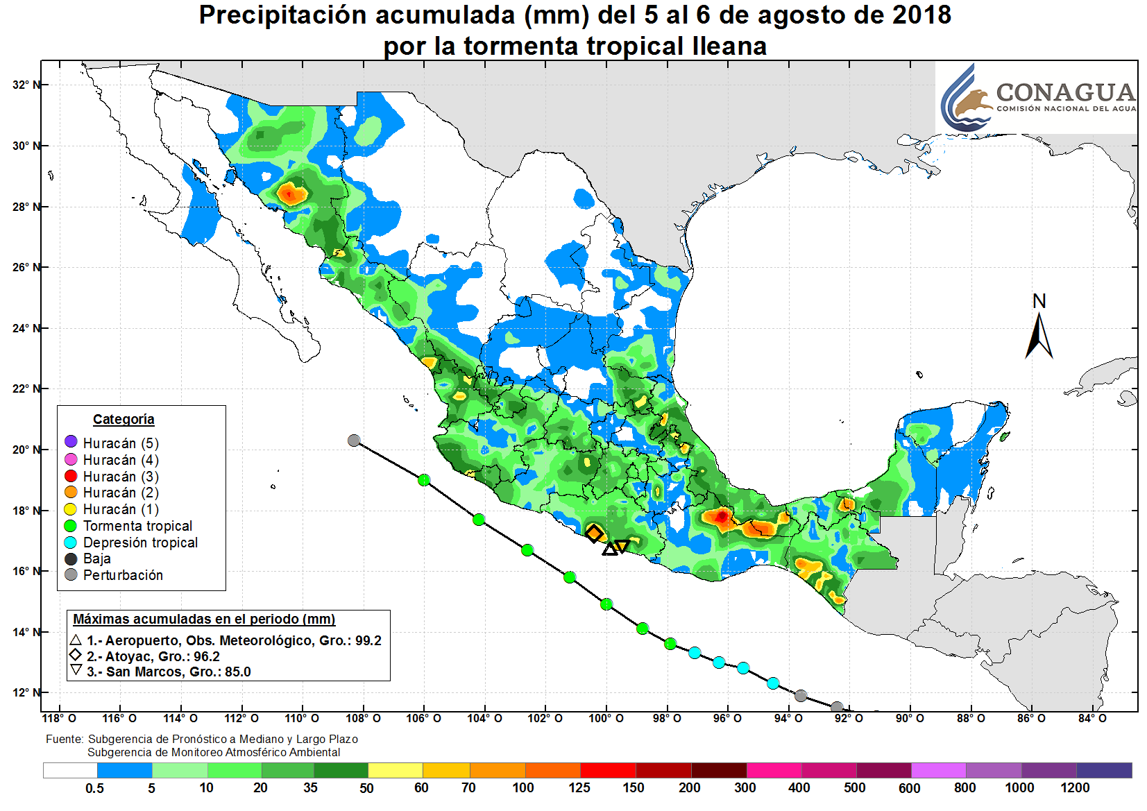
Ileana continued to strengthen over the next day after entering an area with warm sea surface temperatures of 86 to 88 °F (30 to 31 °C). [8] Ileana reached peak intensity on August 6 at 12:00 UTC with maximum sustained winds of 65 mph (100 km/h) and a minimum central pressure of 998  mbar (29.47  inHg), while located approximately 115 mi (185 km) southwest of Acapulco. [1] Around the same time, Ileana had strong deep convection with cloud temperatures of −121 to −130 °F (−85 to −90 °C). [9] Soon after, microwave imagery and Acapulco radar showed the emergence of an eyewall structure at the mid-levels of the system. [10] By 21:00 UTC on August 6, Ileana had become increasingly intertwined in the outer bands of Hurricane John to the west as the two systems began to experience the Fujiwhara effect. [11] [12] The nearby Sierra Madre Mountains further disrupted Ileana's circulation center. The storm was completely absorbed by John at 12:00 UTC on August 7, just west of Cabo Corrientes. [1]

Preparations and impact

As a precautionary measure, the Government of Mexico issued a tropical storm watch for the country's Pacific coast from Lázaro Cárdenas, Michoacán, to Cabo Corrientes, Jalisco, on August 5 at 22:40 UTC. The watch was upgraded to a tropical storm warning at 03:00 UTC on August 6. Six hours later, the Government of Mexico issued a hurricane watch for Punta San Telmo, Michoacán, to Playa Perula, Jalisco, and a tropical storm watch for the southern tip of Baja California Sur from Los Barrilles to Todos Santos. All watches and warnings were gradually discontinued after Ileana's strongest winds were forecast to remain offshore. [1] [10] Overall, a green alert was issued for Mexico, signifying a low level of danger. [13] Heavy rainfall in association with Ileana prompted the issuance of orange alerts in Álvaro Obregón and Magdalena Contreras as well as yellow alerts for the rest of Mexico City. [14] [15]

In the state of Guerrero, Ileana caused a total of four deaths. On August 5, the body of 35-year-old man was discovered in the Huacapa River in Chilpancingo. The man had reportedly been pushing a car out of a ravine when a strong current pulled him down to the river where he drowned. A fishing boat capsized in Acapulco, causing an 8-year-old and a 15-year-old to fall into the Laguna and drown. [16] [17] The storm caused power outages in multiple Acapulcan neighborhoods and left flooding there. A rainfall total of 3.54 in (90 mm) was recorded at the Acapulco International Airport. [18] Rip currents along the coast at Acapulco resulted in the death of a tourist at La Condesa beach. He was rescued by lifeguards, but later died despite receiving medical treatment. [16] In the nearby municipality of Coyuca de Benítez, at least 20 homes were inundated and numerous streets were flooded. [19] In the municipality of Santiago Choapam in Oaxaca, heavy rains from Ileana caused a landslide that left a house in ruins. All inhabitants of the structure were unharmed. [20] A peak rainfall total of 7.71 in (196 mm) was observed in Jacatepec, Oaxaca. [15] In Jiquipilas, Chiapas, Ileana caused another four deaths on August 6. A vehicle containing 18 individuals was swept away by water currents while attempting to cross a flooded bridge; three children and one adult were later found dead. [21] The state of Michoacán required MX$13.6 million (US$737,000) to repair damage to roads and houses in 15 neighborhoods. [22]

In the state of Mexico, heavy rains from Ileana caused severe flooding; in the municipality of Huixquilucan, two homes were flooded and a sewage canal overflowed. [14] The Anillo Periférico, Mexico City – Toluca highway, and several other roads in the Mexico City Metropolitan Area experienced flooding. The Mexico City Metro (STC) also implemented safety measures for several of its lines, [23] [24] such as the manual operation of trains and decrease in travel speed. [25] The San Jerónimo Canal overflowed in the El Rosal neighborhood in Magdalena Contreras. A tree measuring 15 m (49 ft) in height completely blocked a road and a total of 33 structures were inundated throughout Mexico City. [14]

See also

Related Research Articles

<span class="mw-page-title-main">2008 Pacific hurricane season</span> Hurricane season in the Pacific Ocean

The 2008 Pacific hurricane season was a near-average Pacific hurricane season which featured seventeen named storms, though most were rather weak and short-lived. Only seven hurricanes formed and two major hurricanes. This season was also the first since 1996 to have no cyclones cross into the central Pacific. The season officially began on May 15 in the eastern Pacific and on June 1 in the central Pacific. It ended in both regions on November 30. These dates, adopted by convention, historically describe the period in each year when most tropical cyclone formation occurs in these regions of the Pacific. This season, the first system, Tropical Storm Alma, formed on May 29, and the last, Tropical Storm Polo, dissipated on November 5.

<span class="mw-page-title-main">2012 Pacific hurricane season</span> Hurricane season in the Pacific Ocean

The 2012 Pacific hurricane season was a moderately active Pacific hurricane season that saw an unusually high number of tropical cyclones pass west of the Baja California Peninsula. The season officially began on May 15 in the eastern Pacific Ocean, and on June 1 in the central Pacific (from 140°W to the International Date Line, north of the equator; they both ended on November 30. These dates conventionally delimit the period of each year when most tropical cyclones form in these regions of the Pacific Ocean. However, the formation of tropical cyclones is possible at any time of the year. This season's first system, Tropical Storm Aletta, formed on May 14, and the last, Tropical Storm Rosa, dissipated on November 3.

<span class="mw-page-title-main">Tropical Storm Norman (2006)</span> Pacific tropical storm in 2006

Tropical Storm Norman was a weak tropical cyclone that brought heavy rainfall to southwestern Mexico in October 2006. The fifteenth named storm of the 2006 Pacific hurricane season, Norman developed on October 9 from a tropical wave well to the southwest of Mexico. Unfavorable conditions quickly encountered the system, and within two days of forming, Norman dissipated as its remnants turned to the east. Thunderstorms gradually increased again, as it interacted with a disturbance to its east, and on October 15 the cyclone regenerated just off the coast of Mexico. The center became disorganized and quickly dissipated, bringing a large area of moisture which dropped up to 6 inches (150 mm) of rainfall to southwestern Mexico. Rainfall from the storm flooded about 150 houses, of which 20 were destroyed. One person was injured, and initially there were reports of two people missing due to the storm; however, it was not later confirmed.

<span class="mw-page-title-main">2006 Pacific hurricane season</span> Hurricane season in the Pacific Ocean

The 2006 Pacific hurricane season was the first above-average season since 1997 which produced twenty-five tropical cyclones, with nineteen named storms, though most were rather weak and short-lived. Only eleven hurricanes formed and six major hurricanes. Following the inactivity of the previous seasons, forecasters predicted that season would be only slightly above active. It was also the first time since 2003 in which at least one cyclone of tropical storm intensity made landfall. The season officially began on May 15 in the East Pacific Ocean, and on June 1 in the Central Pacific; they ended on November 30. These dates conventionally delimit the period of each year when most tropical cyclones form in the Pacific basin. However, the formation of tropical cyclones is possible at any time of the year.

<span class="mw-page-title-main">Tropical Storm Dalila (2007)</span> Pacific tropical storm in 2007

Tropical Storm Dalila caused flooding in western Mexico in late July 2007. The seventh tropical cyclone and the fourth named storm of the 2007 Pacific hurricane season, Dalila developed from a tropical wave located well southwest of Mexico on July 22. Initially, northeasterly shear caused the depression to remain disorganized, though by early on July 24, it was upgraded to Tropical Storm Dalila. During the next twenty-four hours, Dalila strengthened slightly further while tracking steadily northwestward, attaining peak winds of 60 mph (97 km/h) early on the following day. Shortly thereafter, Dalila either crossed or moved very close to Socorro Island on July 25. Due to decreasing sea surface temperatures, the storm slowly began to weaken, after curving west-northwestward. Early on July 27, Dalila was downgraded to a tropical depression, several hours before degenerating into a remnant low pressure area.

<span class="mw-page-title-main">Tropical Storm Julio (2002)</span> Tropical storm in 2002

Tropical Storm Julio was a weak and short-lived tropical storm that made landfall along the southern Mexican coast in September 2002. The twelfth named storm of the 2002 Pacific hurricane season, Julio originated from an area of convection that organized into a tropical depression on September 25. Initially forecast to stay offshore, the depression moved northward and strengthened into a tropical storm that same day. Julio turned to the northwest and peaked as a minimal tropical storm just before landfall near Lázaro Cárdenas, on September 26. The storm soon weakened into a tropical depression and rapidly dissipated over Mexico that day.

<span class="mw-page-title-main">Tropical Storm Odile (2008)</span> Pacific tropical storm in 2008

Tropical Storm Odile was a late season tropical storm that formed during the 2008 Pacific hurricane season and affected parts of southern Mexico. A tropical depression formed on October 8, and became Tropical Storm Odile 18 hours later. The storm paralleled the south coast of Mexico, with the center located only several miles offshore. After peaking in intensity, increasing southeasterly vertical wind shear induced a trend of rapid weakening on the storm. Correspondingly, Odile was downgraded to a tropical depression early on 12 October, subsequently degenerating into a remnant low about 55 mi (85 km) south of Manzanillo, Colima. From thereon, the low proceeded slowly south-southwestward before dissipating on October 13. Since Odile stayed at sea, its effects along coastlines were limited. The most notable damages were caused by flooding along the southern coast of Mexico, mostly in Chiapas, Oaxaca, Guerrero and Michoacán. The exact amount of damage, however, remains unknown, and no fatalities were reported as a result of the storm.

<span class="mw-page-title-main">Tropical Depression Five-E (2008)</span> Pacific tropical depression in 2008

Tropical Depression Five-E was a tropical depression which made landfall along the south-western Mexican coastline in July 2008. It was the fifth tropical cyclone of the 2008 Pacific hurricane season. The depression developed out of a weak tropical wave which formed off the coast of Africa on June 23. The wave remained poorly organized throughout its journey through the Atlantic Ocean and Caribbean Sea. The wave entered the Eastern Pacific on July 2 after passing through Central America. The wave developed into an area of low pressure that afternoon.

<span class="mw-page-title-main">Hurricane Barbara (2013)</span> Pacific hurricane in 2013

Hurricane Barbara was the easternmost landfalling Pacific hurricane on record. As the first hurricane of the 2013 Pacific hurricane season, Barbara developed from a low-pressure area while located southeast of Mexico on May 28. It headed slowly north-northeastward and strengthened into a tropical storm early on the following day. After recurving to the northeast, Barbara intensified into a Category 1 hurricane on May 29 and made landfall in Chiapas at peak intensity with winds of 80 mph (130 km/h) and a barometric pressure estimated at 983 mbar. When the hurricane made landfall, it was the second earliest landfalling hurricane in the basin since reliable records began in 1966. Barbara then moved across the Isthmus of Tehuantepec and dissipated within the mountainous terrain of Sierra Madre de Chiapas on May 30.

<span class="mw-page-title-main">Tropical Storm Carlos (2003)</span> Pacific tropical storm in 2003

Tropical Storm Carlos was the first of five tropical cyclones to make landfall during the 2003 Pacific hurricane season. It formed on June 26 from a tropical wave to the south of Mexico. It quickly strengthened as it approached the coast, and early on June 27 Carlos moved ashore in Oaxaca with winds of 65 mph (105 km/h). The storm rapidly deteriorated to a remnant low, which persisted until dissipating on June 29. Carlos brought heavy rainfall to portions of southern Mexico, peaking at 337 mm (13.3 in) in two locations in Guerrero. Throughout its path, the storm damaged about 30,000 houses, with a monetary damage total of 86.7 million pesos. At least nine people were killed throughout the country, seven due to mudslides and two from river flooding; there was also a report of two missing fishermen.

<span class="mw-page-title-main">Hurricane Andres (2009)</span> Category 1 Pacific hurricane in 2009

Hurricane Andres was the first named storm and hurricane of the 2009 Pacific hurricane season. Forming on June 21, Andres gradually intensified as it tracked along the Mexican coastline. Deep convection developed around the center of circulation and by June 23, the storm attained hurricane-status, peaking with winds of 80 mph (130 km/h). Upon attaining this intensity, the storm featured a developing eyewall within a central dense overcast. Within 36 hours, the storm rapidly degenerated, having most of the convection being displaced by high wind shear, becoming a non-tropical trough during the afternoon of June 24.

<span class="mw-page-title-main">2013 Pacific hurricane season</span> Hurricane season in the Pacific Ocean

The 2013 Pacific hurricane season was the first to see twenty named storms since 2009 but also had the ninth fewest ACE units on record, as many of the storms were weak and short-lived. The season officially began on May 15 in the Eastern Pacific and started on June 1 in the Central Pacific; both ended on November 30. These dates conventionally delimit the period of each year when most tropical cyclones form east of the International Dateline in the North Pacific basin. The first cyclone, Tropical Storm Alvin, formed on May 15, and the last, Tropical Storm Sonia, dissipated on November 4.

<span class="mw-page-title-main">Hurricane Erick (2013)</span> Category 1 Pacific hurricane in 2013

Hurricane Erick brought minor impacts to the western coastline of Mexico in July 2013, and was the last of a succession of four Category 1 hurricanes to affect the Pacific coast of Mexico early in the 2013 Pacific hurricane season. The fifth named storm and fourth hurricane of the annual season, Erick originated from a tropical wave that moved off the western coast of Africa on June 18. The wave tracked swiftly westward with little development, emerging into the eastern Pacific on July 1. As a result of favorable environmental conditions, the wave developed into a tropical depression on July 4, and further into Tropical Storm Erick at 0000 UTC on July 5. Steered generally west-northwest, Erick intensified into a Category 1 hurricane and reached its peak intensity with winds of 80 mph (130 km/h) on July 6. Its proximity to land and track over increasingly cooler waters caused the storm to deteriorate into a tropical storm the following day, though it remained at such intensity until degenerating into a remnant low early on July 9. The remnant circulation dissipated a few hours later, southwest of Baja California Sur.

<span class="mw-page-title-main">Tropical Storm Trudy (2014)</span> Pacific tropical storm in 2014

Tropical Storm Trudy was a short-lived tropical cyclone in October 2014 that caused significant flooding in southern Mexico. The storm originated from an area of low pressure associated with a monsoon trough near Central America in early October. A slow-moving system, the low eventually consolidated into a tropical depression on October 17 near the Mexican coastline. Favorable environmental conditions aided rapid development of Trudy. Within 15 hours of its designation, an eye formed over the storm's center. Trudy ultimately achieved its peak intensity as a strong tropical storm with 65 mph (100 km/h) winds as it made landfall just southeast of Marquelia, Mexico. The region's mountainous terrain quickly weakened Trudy and the cyclone dissipated early on October 19. Though the cyclone dissipated, its remnant energy later contributed to the formation of Tropical Storm Hanna in the Atlantic.

<span class="mw-page-title-main">Hurricane Carlos (2015)</span> Category 1 Pacific hurricane in 2015

Hurricane Carlos was an unusually small tropical cyclone which affected the western coast of Mexico in June 2015. Forming as the third named storm and hurricane of the annual hurricane season, Carlos developed from a trough first noted by the National Hurricane Center on June 7. The disturbance gradually organized and was designated as a tropical depression three days later while south of the Mexican Pacific coast. Drifting slowly northwestward, the depression was upgraded further to a tropical storm. Although persistent wind shear and dry air hampered intensification early on, Carlos strengthened into a hurricane on June 13 after moving into a more favorable environment. However, the return of dry air and upwelling of cooler waters caused the system to deteriorate into a tropical storm. Paralleling the Mexican coast, Carlos later regained hurricane intensity on June 15 and attained peak winds of 90 mph (140 km/h) a day later. The reprieve was brief, however, as the onset of wind shear, land interaction, and dry air afterward led to rapid weakening. On June 17, Carlos degenerated into a remnant area of low pressure, having made landfall in Jalisco earlier that day. By the morning of June 18, Carlos was declared to have completely dissipated.

<span class="mw-page-title-main">2018 Pacific hurricane season</span> Hurricane season in the Pacific Ocean

The 2018 Pacific hurricane season was one of the most active Pacific hurricane seasons on record, producing the highest accumulated cyclone energy value on record in the basin. The season had the fourth-highest number of named storms – 23, tied with 1982. The season also featured eight landfalls, six of which occurred in Mexico. The season officially began on May 15 in the Eastern Pacific, and on June 1 in the Central Pacific; they both ended on November 30. These dates conventionally delimit the period of each year when most tropical cyclones form in the Pacific basin. However, tropical cyclone formation is possible at any time of the year, as illustrated when the first tropical depression formed on May 10, five days prior to the official start of the season.

<span class="mw-page-title-main">Tropical Storm Carlotta (2018)</span> Tropical Storm in the Pacific of 2018

Tropical Storm Carlotta was a moderately strong tropical cyclone that caused flooding in several states in southwestern and central Mexico. Carlotta, the third named storm of the 2018 Pacific hurricane season, formed as the result of a breakdown in the Intertropical Convergence Zone. On June 12, a broad area of low pressure developed several hundred miles south of Mexico and strengthened into a tropical storm by June 15. The next day, the system stalled unexpectedly within a favorable environment, which led to more intensification than originally anticipated. Early on June 17, Carlotta reached peak intensity with maximum sustained winds of 65 mph (100 km/h) and a minimum central pressure of 997 mbar while located only 30 mi (50 km) south-southeast of Acapulco. The system then began to interact with land and experience wind shear, which resulted in the storm weakening to tropical depression status later in the day. The system weakened to a remnant low early on June 19 and dissipated several hours later.

<span class="mw-page-title-main">Tropical Storm Vicente (2018)</span> Eastern Pacific tropical cyclone with landfall in Mexico

Tropical Storm Vicente was an unusually small tropical cyclone that made landfall as a tropical depression in the Mexican state of Michoacán on October 23, 2018, causing deadly mudslides. The 21st named storm of the 2018 Pacific hurricane season, Vicente originated from a tropical wave that departed from Africa's western coast on October 6. The wave traveled westward across the Atlantic and entered the Eastern Pacific on October 17. The disturbance became better defined over the next couple of days, forming into a tropical depression early on October 19. Located in an environment favorable for further development, the system organized into Tropical Storm Vicente later that day.

<span class="mw-page-title-main">Tropical Storm Dolores (2021)</span> Pacific tropical storm in 2021

Tropical Storm Dolores was a strong tropical storm that affected several states in southwestern Mexico in June 2021. The fourth named storm of the 2021 Pacific hurricane season, Dolores developed from a low-pressure area that formed offshore the state of Oaxaca on June 16, 2021. The area steadily developed deep convection and a closed surface circulation, becoming Tropical Depression Four-E around 09:00 UTC on June 18. The depression quickly strengthened to Tropical Storm Dolores six hours later. As it gradually approached the coast, Dolores steadily intensified despite its proximity to land. It reached peak intensity at 15:00 UTC on June 19 with maximum sustained winds of 70 mph (115 km/h) and a minimum barometric pressure of 990 millibars (29 inHg), just below hurricane strength. Shortly afterward, Dolores made landfall just northwest of Punta San Telmo, Mexico, near the Colima-Michoacán state border. The storm rapidly weakened as it moved inland and dissipated early on June 20 over Zacatecas. However, the storm's mid-level circulation continued northward, before it dissipated later that day.

<span class="mw-page-title-main">Hurricane Blas (2022)</span> Category 1 Pacific hurricane in 2022

Hurricane Blas was a Category 1 hurricane that brought winds and flooding to several Mexican states in June 2022. The second named storm and second hurricane of the 2022 Pacific hurricane season, Blas developed from a low-pressure area off the coast of southwestern Mexico. It became a tropical depression on June 14. and strengthened into a tropical storm later that same day. Blas became a hurricane the next day, while paralleling the coast. The system reached its peak intensity on June 17, at 15:00 UTC, with maximum sustained winds of 80 knots and a central pressure of 976 mbar (28.82 inHg). Later, Blas turned to the west and weakened, becoming a tropical depression on June 20, before transitioning into a post-tropical cyclone on that same day.

References

  1. 1 2 3 4 5 6 7 8 9 Avila, Lixion (November 9, 2018). Tropical Storm Ileana (EP112018) (PDF) (Report). National Hurricane Center. Archived (PDF) from the original on March 29, 2019. Retrieved November 28, 2018.
  2. Blake, Eric (August 3, 2018). Tropical Weather Outlook [14:46 UTC, Fri Aug 03, 2018] (Report). NHC Graphical Outlook Archive. National Hurricane Center. Archived from the original on August 6, 2018. Retrieved March 18, 2020.
  3. Blake, Eric (August 4, 2018). Tropical Weather Outlook [15:53 UTC, Sat Aug 04, 2018] (Report). NHC Graphical Outlook Archive. National Hurricane Center. Archived from the original on November 30, 2018. Retrieved November 29, 2018.
  4. Berg, Robbie (August 4, 2018). Tropical Depression Eleven-E Discussion Number 1 (Report). National Hurricane Center. Archived from the original on December 16, 2018. Retrieved December 16, 2018.
  5. Brennan, Michael (August 5, 2018). Tropical Depression Eleven-E Discussion Number 2 (Report). National Hurricane Center. Archived from the original on November 30, 2018. Retrieved November 29, 2018.
  6. Pasch, Richard (August 5, 2018). Tropical Storm Ileana Advisory Number 5 (Report). National Hurricane Center. Archived from the original on August 5, 2018. Retrieved November 29, 2018.
  7. Pasch, Richard (August 5, 2018). Tropical Storm Ileana Discussion Number 5 (Report). National Hurricane Center. Archived from the original on December 16, 2018. Retrieved December 16, 2018.
  8. Berg, Robbie (August 6, 2018). Tropical Storm Ileana Discussion Number 6 (Report). National Hurricane Center. Archived from the original on December 16, 2018. Retrieved November 29, 2018.
  9. Stewart, Stacy (August 6, 2018). Tropical Storm Ileana Discussion Number 7 (Report). National Hurricane Center. Archived from the original on December 16, 2018. Retrieved November 29, 2018.
  10. 1 2 Pasch, Richard (August 6, 2018). Tropical Storm Ileana Discussion Number 8 (Report). National Hurricane Center. Archived from the original on December 16, 2018. Retrieved December 16, 2018.
  11. Pasch, Richard (August 6, 2018). Tropical Storm Ileana Discussion Number 9 (Report). National Hurricane Center. Archived from the original on December 16, 2018. Retrieved November 29, 2018.
  12. Tropical Storm "Ileana" with a trend in orbiting John (Report). Tropical Cyclone Warning in the Pacific Ocean (in Spanish). Gobierno de México. August 6, 2018. Archived from the original on April 13, 2020. Retrieved March 19, 2020.
  13. Overall Green alert Tropical Cyclone for ILEANA-18 (Report). Global Disaster Alert and Coordination System. August 4, 2018. Archived from the original on April 13, 2020. Retrieved March 18, 2020.
  14. 1 2 3 Mávil, Elizabeth (August 6, 2018). "Lluvia provoca encharcamientos en nueve delegaciones de CDMX". Televisa News (in Spanish). Archived from the original on December 30, 2018. Retrieved December 15, 2018.
  15. 1 2 "Precipitación acumulada (mm) del 5 al 6 de agosto de 2018 por la tormenta tropical Ileana" (Map). gob.mx (in Spanish). Conagua. Retrieved March 12, 2019.
  16. 1 2 Cervantes, Juan (August 6, 2018). "Arrecian efectos de la tormenta "Ileana" en Guerrero". El Universal (in Spanish). Archived from the original on October 28, 2018. Retrieved August 7, 2018.
  17. "Hallan cadáveres de dos niños en laguna de Acapulco". Sipse (in Spanish). August 6, 2018. Archived from the original on April 1, 2019. Retrieved December 15, 2018.
  18. "Tormenta Ileana deja apagones a su paso por Acapulco". UnoTV (in Spanish). August 6, 2018. Archived from the original on December 15, 2018. Retrieved December 15, 2018.
  19. "Tormenta tropical "Ileana" deja cuatro muertos en Guerrero". Diario de Yucatán (in Spanish). August 7, 2018. Archived from the original on April 1, 2019. Retrieved December 15, 2018.
  20. Olivera, Alondra (August 7, 2018). "Tormenta "IIeana" provoca deslizamiento y sepulta vivienda en Oaxaca". La Silla Rota (in Spanish). Archived from the original on April 1, 2019. Retrieved December 15, 2018.
  21. "Tormenta 'Ileana' y huracán 'John' causan 7 muertes". Excélsior (in Spanish). Huffington Post. August 7, 2018. Archived from the original on May 8, 2019. Retrieved October 25, 2018.
  22. Alfaro, Fatima Paz (August 7, 2018). "Sin daños por paso de huracanes Ileana y John en Michoacán". Capital Michoacán (in Spanish). Archived from the original on October 23, 2018. Retrieved October 25, 2018.
  23. "Se activa alerta amarilla por lluvias en varias delegaciones de la CDMX". Regeneracion (in Spanish). August 5, 2018. Archived from the original on April 2, 2019. Retrieved December 15, 2018.
  24. "Lluvias dejan inundaciones en la capital". La Silla Rota (in Spanish). August 5, 2018. Archived from the original on December 15, 2018. Retrieved December 15, 2018.
  25. "¿Qué es y cómo funciona la marcha de seguridad en el Metro?". Chilango (in Spanish). June 14, 2018. Archived from the original on March 23, 2020. Retrieved March 23, 2020.

PD-icon.svg This article incorporates public domain material from websites or documents of the National Weather Service .

Tropical Storm Ileana
Ileana 2018-08-05 1725Z.jpg
Tropical Storm Ileana near peak intensity off the western coast of Mexico on August 5