
Ambler Airport is a state-owned public-use airport located one nautical mile (1.85 km) north of the central business district of Ambler, a city in the Northwest Arctic Borough of the U.S. state of Alaska.

Atqasuk Edward Burnell Sr. Memorial Airport is an uncontrolled public use airport located one nautical mile (2 km) south of the central business district of Atqasuk, a city in North Slope Borough, Alaska, United States. The airport is owned by North Slope Borough.
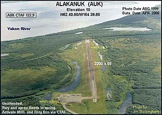
Alakanuk Airport is a state-owned public-use airport located 2 nautical miles (3.7 km) west of the central business district of Alakanuk, a city in the Kusilvak Census Area of the U.S. state of Alaska.

Haines Airport is a state-owned public-use airport located three nautical miles (6 km) west of the central business district of Haines, a city in the Haines Borough in the U.S. state of Alaska. It is the primary airport serving the Haines, Klukwan, Haines Borough area and is situated on the Haines Highway, directly adjacent to the Chilkat River.

Hoonah Airport is a state-owned public-use airport located one nautical mile (2 km) southeast of the central business district of Hoonah, Alaska.
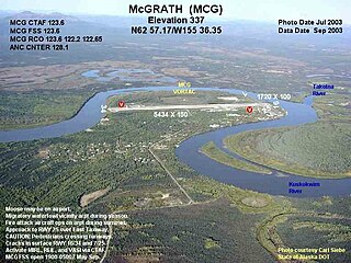
McGrath Airport is a state-owned public-use airport serving McGrath, a city in the Yukon-Koyukuk Census Area of the U.S. state of Alaska.

Ralph M. Calhoun Memorial Airport is a state-owned public-use airport located one nautical mile (1.85 km) west of the central business district of Tanana, a city in the Yukon-Koyukuk Census Area of the U.S. state of Alaska.
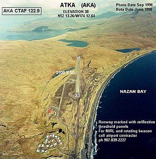
Atka Airport is a state-owned, public use airport located two nautical miles (4 km) north of the central business district of Atka, a city on Atka Island in the U.S. state of Alaska. Scheduled commercial airline passenger service is subsidized by the Essential Air Service program.
Circle City Airport is a state-owned public-use airport located in Circle, in the Yukon-Koyukuk Census Area of the U.S. state of Alaska. It is also known as Circle City (New) Airport. Scheduled commercial airline service is subsidized by the Essential Air Service program.
Egegik Airport is a city-owned, public-use airport serving Egegik, a city in the Lake and Peninsula Borough of the U.S. state of Alaska. Scheduled passenger service is available at this airport.
Nikolski Air Station is an unattended airport located in Nikolski on Umnak Island in the Aleutians West Census Area of the U.S. state of Alaska. This former military airport is now owned by The Aleut Corporation.
Port Alexander Seaplane Base is a city owned, public use seaplane base located in Port Alexander, a city at the southeastern corner of Baranof Island in the Petersburg Borough of the U.S. state of Alaska. It is included in the National Plan of Integrated Airport Systems for 2011–2015, which categorized it as a general aviation facility.

Anaktuvuk Pass Airport is a public use airport located in Anaktuvuk Pass, a city in the North Slope Borough of the U.S. state of Alaska. The airport is owned by North Slope Borough.

Kobuk Airport is a state-owned public-use airport located in Kobuk, a city in the Northwest Arctic Borough of the U.S. state of Alaska.
Sand Point Airport is a state owned, public use airport located two nautical miles (4 km) southwest of the central business district of Sand Point, a city in the Aleutians East Borough in the U.S. state of Alaska. Scheduled airline service to Anchorage International Airport is provided by Peninsula Airways (PenAir).
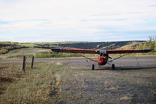
Ruby Airport is a state-owned public-use airport located one nautical mile (1.85 km) southeast of the central business district of Ruby, a city in the Yukon-Koyukuk Census Area of the U.S. state of Alaska.
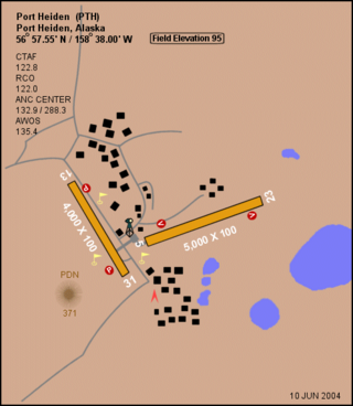
Port Heiden Airport is a state-owned public-use airport located six nautical miles northeast of the central business district of Port Heiden, in the Lake and Peninsula Borough of the U.S. state of Alaska. Scheduled airline service to King Salmon Airport is provided by Peninsula Airways (PenAir).
Port Moller Airport is a publicly owned, private-use airport located 87 nautical miles northeast of the central business district of Cold Bay, in the Aleutians East Borough of the U.S. state of Alaska. It is owned by the U.S. Department of the Interior, Bureau of Land Management. It was previously known as Port Moller Air Force Station.

Nikolai Airport is a state-owned public-use airport located one nautical mile (1.85 km) northeast of the central business district of Nikolai, a city in the Yukon-Koyukuk Census Area of the U.S. state of Alaska.
Umiat Airport is a state owned, public use airport located in Umiat, in the North Slope Borough of the U.S. state of Alaska. The original runway was created by Seabees of Construction Battalion Detachment 1058 in 1945. They built it to facilitate the resupply of their drilling operation at Umiat.


