Whitecap Mountain (British Columbia)

Last updated
Whitecap Mountain
Canada British Columbia relief location map.jpg
Red triangle with thick white border.svg
Whitecap Mountain
Location in British Columbia
Canada relief map 2.svg
Red triangle with thick white border.svg
Whitecap Mountain
Whitecap Mountain (Canada)
Highest point
Elevation 2,918 m (9,573 ft) [1]
Prominence 1,533 m (5,030 ft) [1]
Isolation 71.44 km (44.39 mi) [1]
Listing Highest major summits of Canada
Ultras of North America
Isolated major summits of Canada
Mountain peaks of Canada
Mountains of British Columbia
Coordinates 50°42′58″N122°30′32″W / 50.71611°N 122.50889°W / 50.71611; -122.50889 [2]
Geography
Location British Columbia, Canada
District Lillooet Land District
Parent range Coast Mountains
Bendor Range [1]
Topo map NTS 92J10 Birkenhead Lake

Whitecap Mountain is a 2,918-metre (9,573-foot) summit in British Columbia, Canada.

Contents

Description

Whitecap Mountain is the highest point in the Bendor Range which is a subrange of the Coast Mountains. [1] [3] The remote glaciated peak is located 50 kilometres (31 mi) north-northeast of Pemberton and 40 kilometres (25 mi) west of Lillooet. Precipitation runoff from this mountain's south slope drains to Anderson Lake via Connel Creek, the northwest slope drains to Carpenter Lake via Keary Creek, and the east slope drains to Seton Lake via Whitecap Creek. This is all within the Fraser River watershed. [1] Whitecap Mountain is notable for its steep rise above local terrain as topographic relief is significant with the summit rising over 1,300 metres (4,265 ft) above the Connel Creek valley in 2.5 kilometres (1.6 mi). The mountain's local descriptive toponym was officially adopted on March 31, 1924, by the Geographical Names Board of Canada. [2]

Climate

Based on the Köppen climate classification, Whitecap Mountain is located in a tundra climate zone. [4] Most weather fronts originate in the Pacific Ocean, and travel east toward the Coast Mountains where they are forced upward by the range (orographic lift), causing them to drop their moisture in the form of rain or snowfall. As a result, the Coast Mountains experience high precipitation, especially during the winter months in the form of snowfall. Winter temperatures can drop below −20 °C with wind chill factors below −30 °C. This climate supports three unnamed glaciers on the north, northwest, and east slopes of the mountain.

See also

Related Research Articles

<span class="mw-page-title-main">Mount Matier</span> Mountain in the country of Canada

Mount Matier is a prominent 2,783-metre (9,131-foot) mountain summit located in the Coast Mountains, in Joffre Lakes Provincial Park, in southwestern British Columbia, Canada. It is the highest point of the Joffre Group, which is a subset range of the Coast Mountains. It is situated 26 km (16 mi) east of Pemberton, and 9 km (6 mi) northeast of Lillooet Lake. Its nearest higher peak is Mount Weart, 30 km (19 mi) to the southwest. The slopes of the mountain are covered by the Matier Glacier on the northwest, Anniversary Glacier on the northeast, Twin One Glacier on the southeast, and Hartzell Glacier to the south. Precipitation runoff from the peak drains into Joffre Creek and Twin One Creek, both tributaries of the Lillooet River.

<span class="mw-page-title-main">Mount Spetch</span> Mountain in British Columbia, Canada

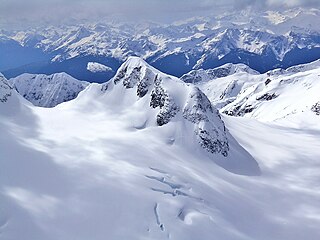
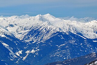
Mount Spetch is a 2,579-metre (8,461-foot) mountain summit located in the Coast Mountains, in Joffre Lakes Provincial Park, in southwestern British Columbia, Canada. It is part of the Joffre Group, which is a subset of the Lillooet Ranges. It is situated 25 km (16 mi) east of Pemberton, midway between Mount Matier and Slalok Mountain, both one kilometre either side of Spetch. The mountain's name was submitted by Karl Ricker of the Alpine Club of Canada to honor Samuel W. Spetch, who operated the general store at Birken, and other businesses in Pemberton. The name was officially adopted on January 23, 1979, by the Geographical Names Board of Canada. The first ascent of the mountain was made in 1971 by J. Oswald and G. Walter. Precipitation runoff from the peak drains into Joffre Creek and Twin One Creek, both tributaries of the Lillooet River. The mountain and its climate supports the Matier Glacier on the northern slope.

<span class="mw-page-title-main">Lydia Mountain</span>

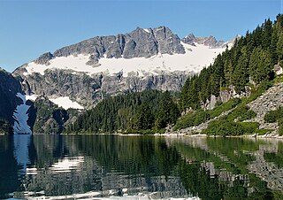
Lydia Mountain is a 2,100-metre (6,890-foot) summit located in the Tantalus Range, in Tantalus Provincial Park, in southwestern British Columbia, Canada. It is situated 14.5 km (9 mi) northwest of Squamish, and 5.46 km (3 mi) south-southeast of Mount Tantalus, which is the highest peak in the Tantalus Range. The nearest higher neighbor is The Red Tusk, 0.5 km (0 mi) to the west, and Mount Niobe lies 2.17 km (1 mi) to the east-southeast. Lake Lovely Water lies below the eastern slope of the peak and precipitation runoff from the peak drains east to the Squamish River, and west to the Clowhom River via Red Tusk Creek. Topographic relief is significant as Lydia Mountain rises 1,400 meters (4,600 feet) above Red Tusk Creek in approximately three kilometers (two miles). The mountain's name was officially adopted on June 6, 1957, by the Geographical Names Board of Canada. The mountain was named for mythic Lydia, of which Tantalus was a primordial ruler in Greek mythology. Several peaks in the Tantalus Range are named in association with Tantalus. The first ascent of Lydia Mountain was made in 1914 by Basil Darling and Allan Morkill.

<span class="mw-page-title-main">Big Snow Mountain (British Columbia)</span> Mountain in the country of Canada

Big Snow Mountain is a 2,357-metre (7,733-foot) mountain summit located in British Columbia, Canada.

<span class="mw-page-title-main">Face Mountain (British Columbia)</span> Mountain summit in British Columbia, Canada

Face Mountain is a 2,485-metre (8,153-foot) mountain summit located in British Columbia, Canada.

<span class="mw-page-title-main">Ipsoot Mountain</span> Glaciated summit in southwest British Columbia, Canada

Ipsoot Mountain is a 2,576-metre (8,451-foot) glaciated summit located in southwest British Columbia, Canada.

<span class="mw-page-title-main">Kumkan Peak</span> Mountain in British Columbia, Canada

Kumkan Peak is a 2,742-metre (8,996-foot) mountain summit located in British Columbia, Canada.

<span class="mw-page-title-main">Claimpost Peak</span> Mountain in British Columbia, Canada

Claimpost Peak is a 2,671-metre (8,763-foot) mountain summit located in British Columbia, Canada.

<span class="mw-page-title-main">Rhododendron Mountain</span> Mountain in British Columbia, Canada

Rhododendron Mountain is a 2,523-metre (8,278-foot) glaciated summit in British Columbia, Canada.

<span class="mw-page-title-main">Cloudraker Mountain</span> Mountain in British Columbia, Canada

Cloudraker Mountain is a 2,385-metre (7,825-foot) glaciated summit in British Columbia, Canada.

<span class="mw-page-title-main">Mount Sir Richard</span> Mountain in British Columbia, Canada

Mount Sir Richard is a 2,681-metre (8,796-foot) glaciated summit in British Columbia, Canada.

<span class="mw-page-title-main">Outlier Peak</span> Mountain in British Columbia, Canada

Outlier Peak is a 2,422-metre (7,946-foot) mountain summit in British Columbia, Canada.

<span class="mw-page-title-main">Nivalis Mountain</span> Mountain in British Columbia, Canada

Nivalis Mountain is a 2,659-metre (8,724-foot) mountain summit in British Columbia, Canada.

<span class="mw-page-title-main">Mount Neal</span> Mountain in British Columbia, Canada

Mount Neal is a 2,552-metre (8,373-foot) glaciated summit in British Columbia, Canada.

<span class="mw-page-title-main">Carcajou Peak</span> Mountain in British Columbia, Canada

Carcajou Peak is a 2,239-metre (7,346-foot) mountain summit in British Columbia, Canada.

<span class="mw-page-title-main">Twin Goat Mountain</span> Mountain in British Columbia, Canada

Twin Goat Mountain is a 2,128-metre (6,982-foot) summit in British Columbia, Canada.

<span class="mw-page-title-main">Shudder Mountain</span> Mountain in British Columbia, Canada

Shudder Mountain is a 2,671-metre (8,763-foot) summit in British Columbia, Canada.

<span class="mw-page-title-main">Amicus Mountain</span> Mountain in British Columbia, Canada

Amicus Mountain is a 2,510-metre (8,235-foot) glaciated summit in British Columbia, Canada.

<span class="mw-page-title-main">Tzoonie Mountain</span> Mountain in British Columbia, Canada

Tzoonie Mountain is a 2,123-metre (6,965-foot) summit in British Columbia, Canada.

<span class="mw-page-title-main">Mount Pitt</span> Summit in British Columbia, Canada

Mount Pitt is a 2,487-metre (8,159-foot) summit in British Columbia, Canada.

References

  1. 1 2 3 4 5 6 "Whitecap Mountain, British Columbia". Peakbagger.com. Retrieved 2024-03-04.
  2. 1 2 "Whitecap Mountain". BC Geographical Names .
  3. "Whitecap Mountain, Peakvisor.com" . Retrieved 2024-03-04.
  4. Peel, M. C.; Finlayson, B. L.; McMahon, T. A. (2007). "Updated world map of the Köppen−Geiger climate classification". Hydrol. Earth Syst. Sci. 11 (5): 1633. Bibcode:2007HESS...11.1633P. doi: 10.5194/hess-11-1633-2007 . ISSN   1027-5606.