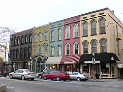
Depot Town is a commercial area, with some residences above storefronts, in Ypsilanti, Michigan's historic district. Depot Town proper consists of East Cross Street from the Huron River to North River Street, and a small area on the 300-block of North River Street. However, several blocks in the surrounding area are also commonly referred to as part of Depot Town. These areas include Riverside Park, Frog Island Park, and River Street extending north and south for several blocks. First established in the late 1830s, most of the buildings standing today were constructed between 1850 and 1880. Over the years, Depot Town has included hotels, an Underground Railroad station, an American Civil War barracks, and a building that has housed a bar and restaurant continuously for more than 150 years, switching to soft drinks during Prohibition. Today the area is dominated by restaurants and stores. Depot Town also hosts several large summer festivals each year, as well as weekly bike nights and cruise nights.

Capitol View/Stifft's Station is a neighborhood of Little Rock, Arkansas, in the west-central portion of the city encompassing approximately 1500 homes. Roughly, its boundaries include the area south of West Markham, north of Interstate 630, east of Pine, and west of Summit, as well as south of Riverview between Park and Summit. Capitol View/Stifft's Station is just west of Downtown, north of the Central High School Historic District, southeast of Pulaski Heights and uses the 72205 ZIP code.

The West Canfield Historic District is a neighborhood historic district located primarily on Canfield Avenue between Second and Third Streets in Detroit, Michigan. A boundary increase enlarged the district to include buildings on Third Avenue between Canfield and Calumet. The district was designated a Michigan State Historic Site in 1970 and listed on the National Register of Historic Places in 1971; a boundary increase was added in 1997. The revitalized 1870s era neighborhood is one of the residential areas surrounding the city's Cultural Center Historic District in Midtown. Nearby, East Canfield Avenue leads to the Detroit Medical Center complex, the Romanesque Revival styled St. Josaphat's Catholic Church, and the Gothic revival styled Sweetest Heart of Mary Catholic Church.

Highland Heights–Stevens' Subdivision Historic District is a residential historic district located in Highland Park, Michigan along five east-west streets: Farrand Park, McLean Street, Colorado Street, Rhode Island Street, and Massachusetts Street, between Woodward Avenue on the west and Oakland Avenue on the east. The district was listed on the National Register of Historic Places in 1988.

The Northville Historic District is located in Northville, Michigan. It was designated a Michigan State Historic Site in 1970 and listed on the National Register of Historic Places in 1972. The district is roughly bounded by Cady Street, Rogers Street, and Randolph Street; alterations to the boundaries of the city-designated district in 2003 and 2007 included structures on the opposite sides of the original bounding streets within the district. The district is located in the heart of old Northville, and is primarily residential, although the 73 contributing structures, include several commercial buildings and a church. The majority of the district contains Gothic Revival houses constructed between 1860 and 1880.

The East River Road Historic District is a historic district located along East River Road near the Grosse Ile Parkway in Grosse Ile, Michigan. The district includes eleven structures, including seven houses, two outbuildings, St. James Episcopal Church, and the Michigan Central Railroad depot. The district stretches from St. James Episcopal Church on the south to Littlecote on the north. The district was designated a Michigan State Historic Site in 1972 and listed on the National Register of Historic Places in 1973. The historically significant 1870s customs house was moved into the district in 1979.

The Spring–Douglas Historic District is a set of 496 buildings in Elgin, Illinois. Of those, 455 buildings contribute to the district's historical value. It is a residential district following Spring Street and Douglas Avenue from Kimball Street in the south to River Bluff Road to the north. The lands that now comprise the district were originally settled by Phineas J. Kimball and Vincent Lovell in the 1830s. Kimball's property eventually became the southern part of the district, which mostly housed working-class citizens. Lovell's subdivisions became housing for wealthier managers and doctors. The lower district is noted for its vernacular architecture, mostly gablefront houses, while the upper district represents a wide array of late 19th and early 20th century styles, mostly Queen Anne.

The Shelden Avenue Historic District is a commercial historic district located along Shelden, Lake, & Montezuma Avenues in Houghton, Michigan. The district contains 43 contributing buildings in an area of 22 acres. It was listed on the National Register of Historic Places in 1987.

The John J. Michels House is a private house located at 1121 E. Houghton Avenue in Houghton, Michigan. It was designated a Michigan State Historic Site in 1989 and placed on the National Register of Historic Places in 1991.
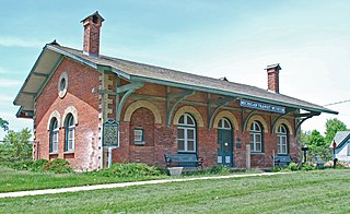
Mount Clemens station is a historic railroad depot located at 198 Grand Street in Mt. Clemens, Michigan. Young Thomas Edison learned telegraphy at this station. The building was listed on the National Register of Historic Places in 1981 as the Grand Trunk Western Railroad, Mount Clemens Station and designated a Michigan State Historic Site in 1973. It is now operated as the Michigan Transit Museum.

The Iron County MRA is a Multiple Resource Area addition to the National Register of Historic Places, which includes 72 separate structures and historic districts within Iron County, Michigan, United States of America. These properties were identified and placed on the Register in 1983, with the exception of one property that was placed on the Register in 1993.

The Ladies' Literary Club Building, also known as the William M. Davis House or the Arden H. Ballard House, was built as a private home, and is currently used as the meeting place for the Ladies' Literary Club. It is located at 218 North Washington Street Ypsilanti, Michigan. It was designated a Michigan State Historic Site in 1965 and listed on the National Register of Historic Places in 1972.

The Chelsea Commercial Historic District is a historic district located along both sides of Main Street from Orchard to North Street in Chelsea, Michigan; the district also includes the adjacent 100 blocks of Jackson, East Middle, and West Middle Streets, as well as structures on Park, East, and Orchard Streets. It was listed on the National Register of Historic Places in 2011.

The Boardman Neighborhood Historic District is a residential historic district in Traverse City, Michigan, United States, roughly bounded by State Street, Webster Street, Railroad Avenue, and Boardman Avenue. It was listed on the National Register of Historic Places in 1978.

The Twin City Historic District in Twin City in Emanuel County, Georgia is a historic district which was listed on the National Register of Historic Places in 2014.

The South Monroe Street Historic District is a primarily residential historic district located at 89-175 and 90-146 South Monroe Street, and 17 Park Avenue, in Coldwater, Michigan. It was listed on the National Register of Historic Places in 1990. It is the best-preserved section of modest houses constructed in Coldwater in the 1850s-1870s, and contains the former Lake Shore & Michigan Southern depot, constructed in 1883.

The Franklin Boulevard Historic District is a primarily residential historic district located in Pontiac, Michigan along Franklin Boulevard between West Huron Street and Orchard Lake Avenue. It also contains structures along Mary Day and Henry Clay Avenues between Franklin and Miller, and some structure along West Huron between Franklin and Williams, and along West Lawrence between Williams and the railroad. The district was listed on the National Register of Historic Places in 1983.

The North Milford Village Historic District is a historic district located in Milford, Michigan, including the commercial area along Main Street from the Huron River to Summit, industrial areas around the mill ponds west of Main, and residential areas east of Main. The district was listed on the National Register of Historic Places in 2000.

The North Michigan Avenue Historic District is a residential historic district located along Michigan Avenue, from Monroe Street on the south to just north of Remington Street in Saginaw, Michigan. It was listed on the National Register of Historic Places in 1982.

The Charlotte Central Historic District is a mixed commercial, residential, and historic district located in the downtown section of Charlotte, Michigan. The district stretches along Cochran Avenue from West McClure Street to south of Henry Street, containing portions of the streets adjacent to Cochran. It was listed on the National Register of Historic Places in 2020.