
Fayette County is a county located in the U.S. state of Alabama. As of the 2020 census, the population was 16,321. Its county seat is Fayette. Its name is in honor of the Marquis de Lafayette, who aided General George Washington in the American Revolutionary War.

Marion County is a county of the U.S. state of Alabama. As of the 2020 census the population was 29,341. The county seat is Hamilton. The county was created by an act of the Alabama Territorial General Assembly on February 13, 1818. The county seat was originally established in Pikeville in 1820, and moved to Hamilton in 1881. The county was named by planter and US Indian agent John Dabney Terrell, Sr., in recognition of General Francis Marion of South Carolina.

Harnett County is a county located in the U.S. state of North Carolina. As of the 2020 census, the population was 133,568. Its county seat is Lillington; its largest community is Anderson Creek. Harnett County is part of the Anderson Creek, NC Micropolitan Statistical Area.

Cleburne County is a county located in the U.S. state of Arkansas. As of the 2020 census, the population was 24,711. The county seat and most populous city is Heber Springs. The county was formed on February 20, 1883, as the last of Arkansas's 75 counties to be formed. It is named for Confederate Major-General Patrick Cleburne. Cleburne is an alcohol prohibition or dry county.

Gu-Win is a town in Fayette and Marion counties in the U.S. state of Alabama. It incorporated in 1956. At the 2020 census the population was 141, down from 176 at the 2010 census. Although a small portion of the town is within Fayette County, all of the population as of 2010 resided in Marion County.

Winfield is a city in Marion and Fayette counties in the U.S. state of Alabama. The population was 4,845 at the 2020 census, the second largest city in Marion County.

Aliceville is a city in Pickens County, Alabama, United States, located thirty-six miles west of Tuscaloosa. At the 2010 census its population was 2,486, down from 2,567 in 2000. Founded in the first decade of the 20th century and incorporated in 1907, the city has become notable for its World War II-era prisoner-of-war camp, Camp Aliceville. Since 1930, it has been the largest municipality in Pickens County.

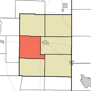
Lauramie Township is one of thirteen townships in Tippecanoe County, Indiana, United States. As of the 2010 census, its population was 2,596 and it contained 1,021 housing units.

Harmony Township is one of six townships in Union County, Indiana, United States. As of the 2010 census, its population was 543 and it contained 233 housing units.
Liberty Township is one of six townships in Union County, Indiana, United States. As of the 2010 census, its population was 1,042 and it contained 447 housing units.

Wayne Township is one of thirteen townships in Henry County, Indiana, United States. As of the 2010 census, its population was 4,216 and it contained 1,828 housing units.

Jackson Township is one of fifteen townships in Wayne County, Indiana, United States. As of the 2010 census, its population was 4,660 and it contained 2,136 housing units.

Washington Township is one of fifteen townships in Wayne County, Indiana, United States. As of the 2010 census, its population was 1,436 and it contained 626 housing units.

Richland Township is a township in Delaware County, Iowa, USA. As of the 2000 census, its population was 575.
Llagas-Uvas is an unincorporated census county division (CCD) located on the eastern side of the Santa Cruz Mountains in southwest Santa Clara County, California. The area covers approximately 102 square miles (260 km2), much of it open space, and contains the Uvas and Chesbro reservoirs, as well as the Calero, Uvas Canyon, Rancho Cañada del Oro, and Mount Madonna county parks.

Dover Township is one of twenty townships in Fayette County, Iowa, USA. As of the 2010 census, its population was 465.

Eden Township is one of twenty townships in Fayette County, Iowa. As of the 2010 census, its population was 623.

Fairfield Township is one of twenty townships in Fayette County, Iowa, USA. As of the 2010 census, its population was 652.

Westfield Township is one of twenty townships in Fayette County, Iowa, USA. As of the 2010 census, its population was 297.

Lake Arrowhead is a private community and census-designated place (CDP) in Clinton County, Missouri, United States. It is in the southeastern part of the county, surrounding a lake of the same name. It is 4 miles (6 km) south of Lathrop, 3 miles (5 km) north of Holt, and 33 miles (53 km) northeast of Kansas City. It is served by the Lathrop post office.
