St Andrew's Cross, Glasgow

Last updated

St Andrew's Cross
  • Eglinton Toll
Glasgow UK location map.svg
Red pog.svg
St Andrew's Cross
Location within Glasgow
OS grid reference NS584634
Council area
Lieutenancy area
  • Glasgow
Country Scotland
Sovereign state United Kingdom
Post town GLASGOW
Postcode district G5, G41, G42
Dialling code 0141
Police Scotland
Fire Scottish
Ambulance Scottish
List of places
UK
Scotland
Glasgow
55°50′35.1″N4°15′45.5″W / 55.843083°N 4.262639°W / 55.843083; -4.262639

St Andrew's Cross, also known as Eglinton Toll, is a road junction in the south side of the city of Glasgow, Scotland. First constructed during the early 1800s, the junction formerly held several buildings including a power station and cinema, but have been removed for a variety of reasons. Since 1946 when the junction underwent a realignment, the two roads no longer intersect.

Contents

Description

The junction includes two roads running roughly north-south which meet, but do not intersect for vehicular traffic since a realignment in 1946: [1] [2] [3] the west thoroughfare (A77) is known as Eglinton Street from Laurieston (the Gorbals) until it reaches the junction then becomes Pollokshaws Road to Strathbungo and beyond, while the east thoroughfare is Pollokshaws Road from Laurieston until the same point then is renamed Victoria Road entering Govanhill. Maxwell Road also meets the junction from the west (Pollokshields) but this is also blocked off for vehicles. Addresses on each side of the cross come under three different postcodes (G5, G41 and G42), indicating its status as a locality which is not classed as falling fully within any single district of the city. [4]

History

Wedge-shaped tenement building at the north apex (constructed 1878) displaying 'St Andrew's Cross' lettering St Andrews Cross - geograph.org.uk - 1151407.jpg
Wedge-shaped tenement building at the north apex (constructed 1878) displaying 'St Andrew's Cross' lettering

It was named after Saint Andrew due to the junction forming the shape of the saltire. [5]

The alternative name, Eglinton Toll, [2] derives from the cross being the southern entry to the Port Eglinton industrial area (roughly between Pollokshields to the south and Tradeston to the north). As its name suggests, it was intended to be a dock area serving as the Glasgow terminus of a waterway (the Glasgow, Paisley and Johnstone Canal) established in the early 19th century by Hugh Montgomerie, 12th Earl of Eglinton which was intended to run to the coast of Ayrshire; the route was never fully completed and in the 1880s the canal was replaced by a railway (today the Paisley Canal line and the Inverclyde/Ayrshire lines). [6] [7] A major fire occurred at Port Eglinton in 1972. [8] In 2010, the area was bisected by the extended M74 motorway which is carried through on a viaduct supported by large pillars. [9] [10] [11]

View of the junction looking south, showing modern apartment block on the site of the Plaza Ballroom Eglinton Street Glasgow (geograph 1829660).jpg
View of the junction looking south, showing modern apartment block on the site of the Plaza Ballroom
Facade of disused St Andrew's Works (power station / print works) St Andrew's Works - geograph.org.uk - 1660708.jpg
Facade of disused St Andrew's Works (power station / print works)

Several local bus routes (previously also trams) [2] use the roads meeting at the cross, and its proximity to the Larkfield bus depot off Victoria Road made it a popular point for drivers to relieve one another at shift ends, [12] [13] with the Star Bar public house and diner, noted for its bargain meal prices [14] [15] located at its northern apex receiving much of its patronage from them. This practice has become less common since the closure of the depot in 2014, [16] with the new facility, which opened later the same year, located a few blocks further east at Cathcart Road. [17]

The cross also once had a power station, [18] [19] a gasworks, [20] a tram depot (1890s), [21] [22] a cinema [23] and a large dance hall, The Plaza Ballroom, in its vicinity; [24] [25] the latter has since been demolished and replaced by modern apartments which incorporate some of the original red sandstone facade, [26] while part of the power station, which was later adapted by the local council into a printing works, survives but as a derelict structure. [27]

There are several new residential developments nearby at Barrland Street [28] [29] and on the sites of the cinema, the gasworks [30] [31] and Larkfield bus depot. [16] In addition to many buses, Pollokshields East railway station is located a short distance to the south-east, adjacent to the Tramway (arts centre) (based within the tram depot buildings) [32] the headquarters of Scottish Ballet, and the Guru Granth Sahib Sikh Sabha, a major Sikh temple. [33]

Related Research Articles

<span class="mw-page-title-main">Glasgow City Council</span> Scottish unitary authority council in Glasgow, Scotland

Glasgow City Council is the local government authority for Glasgow City council area, Scotland. In its modern form it was created in 1996. Glasgow was formerly governed by a corporation, also known as the town council, from the granting of its first burgh charter in the 1170s until 1975. From 1975 until 1996 the city was governed by City of Glasgow District Council, a lower-tier authority within the Strathclyde region.

<span class="mw-page-title-main">Kingston Bridge, Glasgow</span> Bridge in Glasgow, Scotland

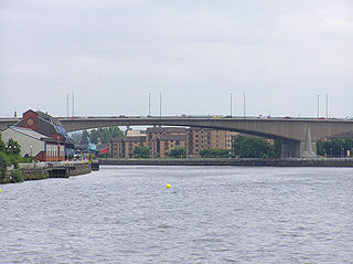
The Kingston Bridge is a balanced cantilever dual-span ten lane road bridge made of triple-cell segmented prestressed concrete box girders crossing the River Clyde in Glasgow, Scotland.

<span class="mw-page-title-main">Pollokshields</span> Human settlement in Scotland

Pollokshields is an area in the Southside of Glasgow, Scotland. Its modern boundaries are largely man-made, being formed by the M77 motorway to the west and northwest with the open land of Pollok Country Park and the Dumbreck neighbourhood beyond, by the Inverclyde Line railway and other branches which separate its territory from the largely industrial areas of Kinning Park, Kingston and Port Eglinton, and by the Glasgow South Western Line running from the east to south, bordering Govanhill, Strathbungo, Crossmyloof and Shawlands residential areas. There is also a suburban railway running through the area.

<span class="mw-page-title-main">Auchenshuggle</span> Human settlement in Scotland

Auchenshuggle is an area of Glasgow in Scotland, to the south of Tollcross.

<span class="mw-page-title-main">Govanhill</span> Area of Glasgow, Scotland

Govanhill is an area of Glasgow, Scotland, situated south of the River Clyde between Pollokshields, the Gorbals, Strathbungo, Crosshill, Polmadie and Queen's Park. Historically part of Renfrewshire, Govanhill had the status of a police burgh between 1877 and 1891 before becoming part of the City of Glasgow. Since 2007, it has fallen under the Southside Central ward of Glasgow City Council. A previous smaller ward named Govanhill had boundaries of Dixon Avenue and Dixon Road to the south, Victoria Road to the west, Butterbiggins Road to the north and Aikenhead Road to the east.

<span class="mw-page-title-main">Newlands, Glasgow</span> Human settlement in Scotland

Newlands is an affluent suburb in the south side of Glasgow, Scotland. The area is mainly residential in character. Shawlands and Langside lie to the north of the district, Pollokshaws and Auldhouse to the west, Giffnock to the south, and Merrylee and Cathcart to the east.

<span class="mw-page-title-main">Tradeston</span> District of Glasgow, Scotland

Tradeston is a small district in the Scottish city of Glasgow adjacent to the city centre on the south bank of the River Clyde. The name reflected its role as a primarly dockland area with a large number of warehouses and wharves along the riverside were vessels would be unloaded. It merges to the south and west with Kingston, and the two districts are often considered one and the same.

<span class="mw-page-title-main">A728 road</span> Road in Scotland

The A728 is a route number in Glasgow, Scotland applied to two connected roads.

<span class="mw-page-title-main">Glasgow Inner Ring Road</span> Proposed road in Glasgow, Scotland, UK

The Glasgow Inner Ring Road is a partially completed ring road encircling the city centre of Glasgow, Scotland. Construction of the roads began in 1965, and half of its circumference was completed by 1972 - forming part of the wider M8 motorway, but no further construction was made and the remaining plans were formally abandoned in 1980.

<span class="mw-page-title-main">A730 road</span> Road in Scotland running from the centre of Glasgow to Cathkin

The A730 road in Scotland runs between the centre of Glasgow and the south-eastern edge of the city's urban area at Cathkin.

The Polloc and Govan Railway was an early mineral railway near Glasgow in Scotland, constructed to bring coal and iron from William Dixon's collieries and ironworks to the River Clyde for onward transportation.

The Cathcart District Railway was proposed to serve the arising demand for suburban residential travel on the south side of Glasgow, Scotland. It was planned as a loop running to and from Glasgow Central station, but at first only the eastern arm, to Cathcart via Queens Park, was built, opening in 1886. The western arm was opened in 1894 and trains operated round the loop. A frequent passenger train service was operated, and there was also a limited goods and mineral operation.

<span class="mw-page-title-main">Leith Walk</span> Street in Edinburgh, Scotland

Leith Walk is one of the longest streets in Edinburgh, Scotland, and is the main road connecting the east end of the city centre to Leith.

<span class="mw-page-title-main">Glasgow Corporation Tramways</span> Closed urban tramway system in Glasgow, Scotland

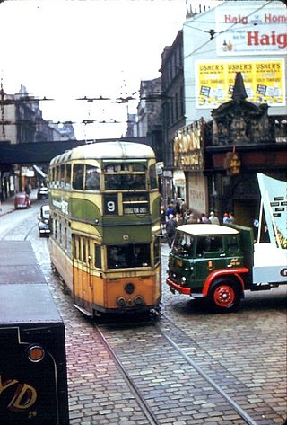
Glasgow Corporation Tramways were formerly one of the largest urban tramway systems in Europe. Over 1000 municipally-owned trams served the city of Glasgow, Scotland, with over 100 route miles by 1922. The system closed in 1962 and was the last city tramway in Great Britain.

<span class="mw-page-title-main">Tramway (arts centre)</span>

Tramway is a contemporary visual and performing arts venue located in the Scottish city of Glasgow. Based in a former tram depot in the Pollokshields area of the South Side, it consists of two performance spaces and two galleries, as well as offering facilities for community and artistic projects. The Hidden Gardens is situated behind Tramway. The new extension to Tramway is the home of the Scottish Ballet, and is claimed to be one of the leading venues of its type in Europe.

<span class="mw-page-title-main">Riverside Museum</span> Transport museum in Glasgow, Scotland.

The Riverside Museum is a museum in the Yorkhill area of Glasgow, Scotland, housed in a building designed by Zaha Hadid Architects, with its River Clyde frontage at the new Pointhouse Quay. It forms part of the Glasgow Harbour regeneration project. The building opened in June 2011, winning the 2013 European Museum of the Year Award. It houses many exhibits of national and international importance. The Govan-Partick Bridge, which will provide a pedestrian and cycle path link from the museum across the Clyde to Govan, is set to be completed in 2024.

<span class="mw-page-title-main">Trolleybuses in Glasgow</span> Public transport system in Glasgow, Scotland

The Glasgow trolleybus system operated in and immediately surrounding the city of Glasgow, Scotland, between 1949 and 1967, with the network reaching its largest extent in 1959. It was the only British system to open after World War II.

The Glasgow Tramway and Omnibus Company operated a horse-drawn tramway service in Glasgow between 1872 and 1894. The tram system was then taken into municipal ownership, becoming Glasgow Corporation Tramways.

<span class="mw-page-title-main">Kingston, Glasgow</span>

Kingston is an area of Glasgow, Scotland, from which the Kingston Bridge takes its name. Together with Ibrox, it forms one of the 56 neighbourhoods of Glasgow defined by Glasgow City Council for operational purposes. The area was assigned to Ward 54 until 2007 when it was reclassified as part of the Govan ward.

References

  1. Glasgow’s Crosses, Glasgow History, 28 May 2016
  2. 1 2 3 When the trams still ruled on the streets of post-war Glasgow, The Herald, 30 December 2016
  3. Laurieston Guide, Scotcities,
  4. "Glasgow postcodes". Postcode Area. Retrieved 8 September 2019.
  5. Smith, Adam (2017). Glasgow The Postcard Collection. Amberley Publishing. p. 172. ISBN   9781445667393.
  6. Port Eglinton (Mitchell Library, Glasgow Collection, 1835), The Glasgow Story
  7. Port Eglinton, Gazetteer for Scotland
  8. Kilbirnie Street Fire (Glasgow City Archives, Deposited Collections), The Glasgow Story
  9. Oblique aerial view of the M74 extension going through the Port Eglinton area, taken from the NW, Canmore, 12 February 2010
  10. M74 Port Eglinton Viaduct launch, Dorman Long Technology, 1 March 2010
  11. Urban park plan for under Glasgow M74 motorway flyover, BBC News, 15 July 2014
  12. The Star Bar, The Bar Biographer, 8 July 2011
  13. The Star Bar: Adventures in Eglinton Toll, Hemi the Headlocker, 1 September 2013
  14. The cheapest pub lunch in the UK?, The Herald, 2 February 2013
  15. We review Glasgow's legendary cheapest lunch – £3 for three courses at the Star Bar, Glasgow Live, 2 January 2019
  16. 1 2 Plans for homes on former Larkfield bus depot site in Govanhill offcially[sic] submitted, Evening Times, 13 January 2018
  17. First Minister Nicola Sturgeon Opens New Caledonia Bus Depot Janus Architecture, 12 December 2014
  18. St. Andrew's Cross Electricity Works, Grace's Guide to British Industrial History
  19. Glasgow, 197–243 Pollokshaws Road, St Andrew's Works, Canmore
  20. Glasgow, 95 Kilbirnie Street, Tradeston Gasworks, Canmore
  21. Glasgow, 522 Pollokshaws Road, Coplaw Horse-tram Depot, Canmore
  22. Coplawhill tram depot (Museum of Transport, R. B. McKim Collection), The Glasgow Story
  23. BB Cinerama / New Cinerama / Odeon Eglinton Toll, Scottish Cinemas and Theatres Project
  24. The last waltz, The Herald, 23 February 1998
  25. Glasgow, Victoria Road, Plaza Ballroom, Canmore
  26. Is this the ugliest new building in Scotland?, Evening Times, 30 January 2009
  27. Gorbals vandalism hotspot could be turned into family play centre, Evening Times, 31 July 2018
  28. Westpoint head south for latest Glasgow build, Urban Realm, 14 May 2018
  29. Southgate Court, Westpoint Homes
  30. 140 affordable homes proposed for Glasgow gasworks site, Scottish Housing News, 17 January 2017
  31. More Than 200 Flats And Townhouses To Be Built At East Pollokshields Site, reGlasgow, 21 February 2019
  32. Tramway – A History, Tramway
  33. Glasgow Gurdwara: £3.8m Sikh temple prepares to open its doors, BBC News, 26 April 2013