Aldershot, Queensland

Last updated

Aldershot
Queensland
Australia Queensland location map.svg
Red pog.svg
Aldershot
Coordinates 25°27′45″S152°39′40″E / 25.4625°S 152.6610°E / -25.4625; 152.6610 (Aldershot (town centre))
Population603 (UCL 2021) [1]
Postcode(s) 4650
Area21.3 km2 (8.2 sq mi)
Time zone AEST (UTC+10:00)
LGA(s) Fraser Coast Region
State electorate(s) Maryborough
Federal division(s)
Localities around Aldershot:
Duckinwilla Walliebum Dundathu
Dunmora Aldershot St Helens
Oakhurst Maryborough West Maryborough
E. A. Weinberg, manager of the Aldershot works, 1895 E. A. Weinberg, manager of the Aldershot works, 1895.JPG
E. A. Weinberg, manager of the Aldershot works, 1895

Aldershot is a rural town and locality in the Fraser Coast Region, Queensland, Australia. [2] [3] In the 2021 census, the locality of Aldershot had a population of 1,311 people. [4]

Contents

Geography

The Bruce Highway passes through from south to north-west. The North Coast railway line forms part of the southern boundary and then passes through the locality and town from south to north. [5] Aldershot railway station is an abandoned railway station on the line ( 25°27′47″S152°39′55″E / 25.4631°S 152.6653°E / -25.4631; 152.6653 (Aldershot railway station) ). [6]

Saltwater Creek, a tributary of the Mary River, runs through the locality from west to east, passing south of the town. [5]

History

The Queensland Smelting Company named the town after Aldershot in England. [2] The company was established in England in 1888 and in 1893 built a smelter in the area. The smelter operated until 1906, when it was relocated to North Queensland to be closer to the mining areas. [7]

Aldershot Post Office opened on 1 September 1892 and closed around 1920. [8]

A primary school opened in Aldershot in 1894. [9] It had closed by 1911, when tenders were called to relocate the school buildings to Maryborough West and the teacher's residence to Gayndah. [10]

Demographics

In the 2016 census, the locality of Aldershot had a population of 1,152 people. [11]

In the 2021 census, the locality of Aldershot had a population of 1,311 people. [4]

Economy

The major industry in Aldershot today is the Maryborough Correctional Centre located at Stein Road ( 25°28′43″S152°38′55″E / 25.4786°S 152.6486°E / -25.4786; 152.6486 (detention centre) ). [12] [13]

Facilities

Aldershot Rural Fire Brigade is at 12 Murray Street ( 25°27′55″S152°39′41″E / 25.4653°S 152.6613°E / -25.4653; 152.6613 (Aldershot Rural Fire Brigade) ). [14]

Related Research Articles

<span class="mw-page-title-main">Tiaro, Queensland</span> Town in Queensland, Australia

Tiaro is a rural town and locality in the Fraser Coast Region, Queensland, Australia. In the 2021 census, the locality of Tiaro had a population of 778 people.

<span class="mw-page-title-main">Howard, Queensland</span> Town in Queensland, Australia

Howard is a rural town and locality in the Fraser Coast Region, Queensland, Australia. It is a southern boundary of the Dundaburra peoples of the Northern Kabi Kabi Isis districts and surrounds. In the 2016 census, Howard had a population of 1,359 people. It is located 284 kilometres (176 mi) north of Brisbane and 37 kilometres (23 mi) west of Hervey Bay.

<span class="mw-page-title-main">Theebine</span> Town in Queensland, Australia

Theebine is a rural town and locality split between the Gympie Region and the Fraser Coast Region, both in Queensland, Australia.

<span class="mw-page-title-main">Gundiah</span> Town in Queensland, Australia

Gundiah is a rural town and locality in the Fraser Coast Region, Queensland, Australia. In the 2016 census, the locality of Gundiah had a population of 123 people.

<span class="mw-page-title-main">Duckinwilla, Queensland</span> Suburb of Fraser Coast Region, Queensland, Australia

Duckinwilla is a rural locality in the Fraser Coast Region, Queensland, Australia. In the 2016 census Duckinwilla had a population of 12 people.

<span class="mw-page-title-main">Torbanlea</span> Town in Queensland, Australia

Torbanlea is a rural town and locality in the Fraser Coast Region, Queensland, Australia. In the 2016 census the locality of Torbanlea had a population of 791 people.

<span class="mw-page-title-main">Antigua, Queensland</span> Suburb of Fraser Coast Region, Queensland, Australia

Antigua is a rural locality in the Fraser Coast Region, Queensland, Australia. In the 2016 census, Antigua had a population of 127 people.

<span class="mw-page-title-main">Mungar</span> Suburb of Fraser Coast Region, Queensland, Australia

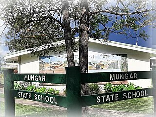
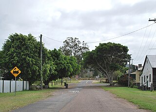
Mungar is a rural locality in the Fraser Coast Region, Queensland, Australia. In the 2021 census, Mungar had a population of 328 people.

<span class="mw-page-title-main">Bauple, Queensland</span> Town in Queensland, Australia

Bauple is a rural town and locality in the Fraser Coast Region, Queensland, Australia. In the 2016 census the locality of Bauple had a population of 644 people.

Owanyilla is a rural town and locality in the Fraser Coast Region, Queensland, Australia. In the 2016 census the locality of Owanyilla had a population of 194 people.

Granville is a rural locality in the Fraser Coast Region, Queensland, Australia. It is a suburb of Maryborough. In the 2016 census Granville had a population of 2,716 people.

<span class="mw-page-title-main">Maryborough West, Queensland</span> Suburb of Maryborough, Queensland, Australia

Maryborough West is a mixed-use locality in the Fraser Coast Region, Queensland, Australia. In the 2016 census, Maryborough West had a population of 531 people.

Kanigan is a rural locality split between the Fraser Coast Region and the Gympie Region, both in Queensland, Australia. In the 2016 census Kanigan had a population of 114 people.

<span class="mw-page-title-main">Oakhurst, Queensland</span> Suburb of Fraser Coast Region, Queensland, Australia

Oakhurst is a mixed-use locality in the Fraser Coast Region, Queensland, Australia. In the 2021 census, Oakhurst had a population of 1,717 people.

<span class="mw-page-title-main">Gootchie, Queensland</span> Suburb of Fraser Coast Region, Queensland, Australia

Gootchie is a rural locality in the Fraser Coast Region, Queensland, Australia. In the 2021 census, Gootchie had a population of 96 people.

Tuan is a coastal rural town and locality in the Fraser Coast Region, Queensland, Australia. In the 2021 census, the locality of Tuan had a population of 140 people.

Netherby is a rural locality in the Fraser Coast Region, Queensland, Australia. In the 2021 census, Netherby had a population of 25 people.

Doongul is a rural locality in the Fraser Coast Region, Queensland, Australia. In the 2021 census, Doongul had a population of 35 people.

<span class="mw-page-title-main">Grahams Creek, Queensland</span> Suburb of Fraser Coast Region, Queensland, Australia

Grahams Creek is a rural locality in the Fraser Coast Region, Queensland, Australia. In the 2021 census, Grahams Creek had a population of 149 people.

Paterson is a rural locality in the Fraser Coast Region, Queensland, Australia. In the 2021 census, Paterson had a population of 157 people.

References

  1. Australian Bureau of Statistics (28 June 2022). "Aldershot (urban centre and locality)". Australian Census 2021.  OOjs UI icon edit-ltr-progressive.svg
  2. 1 2 "Aldershot – town in Fraser Coast Region (entry 263)". Queensland Place Names. Queensland Government . Retrieved 29 November 2019.
  3. "Aldershot – locality in Fraser Coast Region (entry 47501)". Queensland Place Names. Queensland Government . Retrieved 29 November 2019.
  4. 1 2 Australian Bureau of Statistics (28 June 2022). "Aldershot (SAL)". 2021 Census QuickStats. Retrieved 28 February 2023. OOjs UI icon edit-ltr-progressive.svg
  5. 1 2 Google (13 August 2019). "Aldershot, Queensland" (Map). Google Maps . Google. Retrieved 13 August 2019.
  6. "Railway stations and sidings - Queensland". Queensland Open Data. Queensland Government. 2 October 2020. Archived from the original on 5 October 2020. Retrieved 5 October 2020.
  7. "Aldershot". Queensland Places. Centre for the Government of Queensland, University of Queensland. Retrieved 15 March 2014.
  8. Phoenix Auctions History. "Post Office List". Phoenix Auctions. Retrieved 25 February 2021.
  9. "OFFICIAL NOTIFICATIONS". The Brisbane Courier . National Library of Australia. 30 July 1894. p. 6. Retrieved 15 March 2014.
  10. "Advertising". The Brisbane Courier . National Library of Australia. 15 April 1911. p. 10. Retrieved 15 March 2014.
  11. Australian Bureau of Statistics (27 June 2017). "Aldershot (SSC)". 2016 Census QuickStats. Retrieved 20 October 2018. OOjs UI icon edit-ltr-progressive.svg
  12. "Contact Details". Queensland Corrective Services. Queensland Government. Archived from the original on 15 March 2014. Retrieved 15 March 2014.
  13. "Landmark Areas - Queensland". Queensland Open Data. Queensland Government. 18 November 2020. Archived from the original on 21 November 2020. Retrieved 21 October 2020.
  14. "Aldershot Rural Fire Brigade". Facebook . Retrieved 1 May 2024.