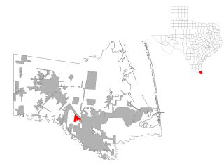
The Alice Micropolitan Statistical Area is in Jim Wells County, Texas. It principal city is Alice, 44 miles from Corpus Christi, Texas, the closest Metropolitan Statistical Area. The closest Micropolitan Statistical Area is 39 miles in Beeville.

Jim Wells County is a county in the U.S. state of Texas. As of the 2020 census, its population was 38,891. The county was founded in 1911 and is named for James B. Wells, Jr. (1850-1923), for three decades a judge and Democratic Party political boss in South Texas.
Scouting in Texas has a long history, from the 1910s to the present day, serving thousands of youth in programs that suit the environment in which they live. Scouting, also known as the Scout Movement, is a worldwide youth movement with the stated aim of supporting young people in their physical, mental and spiritual development, so that they may play constructive roles in society.
Rancho Viejo is a town in Cameron County, Texas, United States. The population was 2,437 at the 2010 census. The town is named from a ranch in that area named "Rancho Viejo". This ranch was owned by Blas María de la Garza Falcón, whose name was given to a nearby dam, Falcon Dam.

The Louisville metropolitan area is the 43rd largest metropolitan statistical area (MSA) in the United States. It had a population of 1,395,855 in 2020 according to the latest official census, and its principal city is Louisville, Kentucky.

Hancock Park is a city park in the Miracle Mile section of the Mid-Wilshire neighborhood in Los Angeles, California.

The Beaumont–Port Arthur metropolitan statistical area is defined by the United States Census Bureau as a three-county region in Southeast Texas. The metropolitan area shares borders with the Houston–The Woodlands–Sugar Land metropolitan area to the west and the Lake Charles metropolitan area in the U.S. state of Louisiana to the east. The area is also known as the Golden Triangle. The "golden" refers to the wealth that came from the Spindletop oil strike near Beaumont in 1901, and "triangle" refers to the area among the cities of Beaumont, Port Arthur, and Orange.
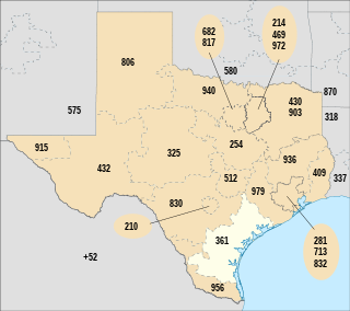
North American area code 361 is a state of Texas telephone area code for numbers in the Corpus Christi area. It was created prior to February 13, 1999, in a split from area code 512.

Pacheco State Park is a California State Park to the south of Pacheco Pass in the Diablo Range, located mostly in western Merced County, California but extending into southeastern Santa Clara County and near Hollister in San Benito County. Located 24 miles (39 km) west of Los Banos, California and 20 miles (32 km) east of Gilroy, the park entrance is on Dinosaur Point Road, a short distance from California State Route 152 near Pacheco Pass. The park contains 6,890 acres (2,790 ha), though only the western 2,600 acres (1,100 ha) to the west are open to the public. The eastern two-thirds of the park are closed due to an underdeveloped trail system and safety concerns over the numerous wind turbines that are located in the Gonzaga Wind Farm that occupies the area. In 2018, it was announced that the 1980s-era turbines would be replaced with more efficient models, which would increase power production capacity from the original 16.5 megawatts (MW) to as much as 80 MW.

4S Ranch is a locale of San Diego County, California. It is located about 25 miles (40 km) north of downtown San Diego and 13 miles (21 km) east of the Pacific Ocean in the North County Inland area of San Diego. To the east of 4S Ranch is the San Diego community of Rancho Bernardo. To the west is the Santa Fe Valley, which includes Rancho Santa Fe. Lake Hodges forms the northern border of the community while Black Mountain Ranch, which includes Del Sur and Santaluz, and Rancho Peñasquitos are both situated to the south. The ZIP Code is 92127, and the community is inside area code 858.

Marvel is an unincorporated town, a post office, and a census-designated place (CDP) located on the Southern Ute Indian Reservation in southwestern La Plata County, Colorado, United States. The CDP is a part of the Durango, CO Micropolitan Statistical Area. The Marvel post office has the ZIP Code 81329.

The Albuquerque–Santa Fe–Las Vegas combined statistical area is made up of eight counties in north central New Mexico. The combined statistical area consists of the Albuquerque and Santa Fe metropolitan statistical areas, and the Las Vegas, Los Alamos, and Española micropolitan statistical areas. The 2013 delineations included the Grants micropolitan statistical area, but it was removed in the 2018 revisions. As of the 2020 census, the CSA had a population of 1,162,523. Roughly 56% of New Mexico's residents live in this area. Prior to the 2013 redefintions, the CSA consisted only of the Santa Fe metropolitan statistical area and the Española micropolitan statistical area. The total land area of the Albuquerque–Santa Fe–Las Vegas combined statistical area in the 2013 definition is 26,421 sq. mi.

The Corpus Christi metropolitan statistical area is a metropolitan area in South Texas that covers three counties—Aransas, Nueces, and San Patricio. As of the 2000 census, the MSA had a population of 413,280.
The Corpus Christi-Kingsville-Alice Combined Statistical Area is made up of six counties in South Texas. The statistical area consists of the Corpus Christi Metropolitan Statistical Area, the Kingsville Micropolitan Statistical Area, and the Alice Micropolitan Statistical Area. As of the 2010 census, the CSA had a population of 501,500.

The Brownsville–Harlingen–Raymondville combined statistical area is made up of two counties in the Rio Grande Valley region of Texas. The CSA consists of the Brownsville–Harlingen metropolitan statistical area and the Raymondville micropolitan statistical area. A 2013 census estimate puts its population at 439,197.

The Brownsville–Harlingen Metropolitan Statistical Area, as defined by the United States Census Bureau, is an area consisting of one county–Cameron–in the Rio Grande Valley region of South Texas, anchored by the cities of Brownsville and Harlingen. The 2012 U.S. Census Bureau estimate places its metropolitan area population at 415,557, ranking as the eighth most populous metropolitan area in the state of Texas. It is also a component of the Brownsville–Harlingen–Raymondville combined statistical area, which covers two counties and had an estimated population of 416,766 as of July 1, 2009.

Abel Stearns was a trader who came to the Pueblo de Los Angeles, Alta California in 1829 and became a major landowner and cattle rancher and one of the area's wealthiest citizens.

Corpus Christi is a coastal city in the South Texas region of the U.S. state of Texas. The county seat of Nueces County, it also extends into Aransas, Kleberg, and San Patricio counties. The population was 277,454 at the 2000 census; in 2006 the U.S. Census Bureau estimated the city's population at 285,175, making it the eighth-largest city in the state. It is the principal city of the three-county Corpus Christi Metropolitan Statistical Area as well as the larger Corpus Christi-Kingsville Combined Statistical Area. The translation from Latin of the city's name is Body of Christ, given to the settlement by the Spanish, in honor of the Blessed Sacrament (Eucharist). The city has been nicknamed The Sparkling City by the Sea, or "Corpitos" particularly in literature promoting tourism.
Rancho El Sur was a 8,949.06-acre (36.22 km2) Mexican land grant in present-day Monterey County, California on the Big Sur coast given in 1834 by Governor José Figueroa to Juan Bautista Alvarado. The grant extended from the mouth of Little Sur River inland about 2.5 miles (4.0 km) over the coastal mountains and south along the coast past the mouth of the Big Sur River to Cooper's Point. In about 1892, the rancho land plus an additional 3,000 acres (1,200 ha) of resale homestead land was divided into two major parcels. The southern 4,800 acres (1,900 ha) became the Molera Ranch, later the foundation of Andrew Molera State Park. The northern 7,100 acres (2,900 ha) formed the El Sur Ranch.
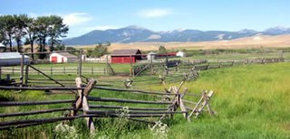
A ranch is an area of land, including various structures, given primarily to ranching, the practice of raising grazing livestock such as cattle and sheep. It is a subtype of a farm. These terms are most often applied to livestock-raising operations in Mexico, the Western United States and Western Canada, though there are ranches in other areas. People who own or operate a ranch are called ranchers, cattlemen, or stockgrowers. Ranching is also a method used to raise less common livestock such as horses, elk, American bison, ostrich, emu, and alpaca.
The El Paso–Las Cruces, Texas–New Mexico, combined statistical area consists of two counties in western Texas and one in southern New Mexico. This CSA was defined as part of the United States Office of Management and Budget's 2013 delineations for metropolitan, micropolitan, and combined statistical areas. As of the 2020 United States Census, the El Paso-Las Cruces CSA had a population of 1,088,420 making it the 56th largest combined statistical area in the United States. The statistical area consists of the metropolitan areas of El Paso, Texas and Las Cruces, New Mexico. This CSA has a GDP of about $33 billion and would rank 58th nationally among all CSA or metro areas. The total land area of the El Paso–Las Cruces combined statistical area is 9,402 sq. mi.
