
Mont Blanc is the highest mountain in the Alps and Western Europe, and the highest mountain in Europe outside the Caucasus Mountains, rising 4,805.59 m (15,766 ft) above sea level, located on the Franco-Italian border. It is the second-most prominent mountain in Europe, after Mount Elbrus, and the 11th most prominent mountain in the world.
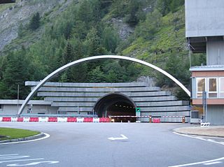
The Mont Blanc Tunnel is a highway tunnel between France and Italy, under Mont Blanc in the Alps. It links Chamonix, Haute-Savoie, France with Courmayeur, Aosta Valley, Italy, via the French Route Nationale 205 and the Italian Traforo T1, in particular the motorways serving Geneva and Turin. The passageway is one of the major trans-Alpine transport routes, particularly for Italy, which relies on this tunnel for transporting as much as one-third of its freight to northern Europe. It reduces the route from France to Turin by 50 kilometres and to Milan by 100 km (60 mi). Northeast of Mont Blanc's summit, the tunnel is about 15 km (10 mi) southwest of the tripoint with Switzerland, near Mont Dolent.

Horace Bénédict de Saussure was a Genevan geologist, meteorologist, physicist, mountaineer and Alpine explorer, often called the founder of alpinism and modern meteorology, and considered to be the first person to build a successful solar oven.

Aosta is the principal city of the Aosta Valley, a bilingual region in the Italian Alps, 110 km (68 mi) north-northwest of Turin. It is situated near the Italian entrance of the Mont Blanc Tunnel and the Great St Bernard Tunnel, at the confluence of the Buthier and the Dora Baltea, and at the junction of the Great and Little St Bernard Pass routes.
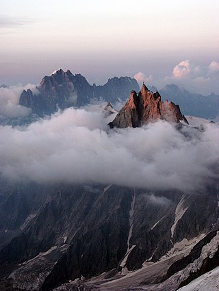
The Aiguille du Midi is a 3,842-metre-tall (12,605 ft) mountain in the Mont Blanc massif within the French Alps. It is a popular tourist destination and can be directly accessed by cable car from Chamonix that takes visitors close to Mont Blanc.

Courmayeur is a town and comune in northern Italy, in the autonomous region of Aosta Valley.
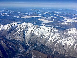
The Mont Blanc massif is a mountain range in the Alps, located mostly in France and Italy, but also straddling Switzerland at its northeastern end. It contains eleven major independent summits, each over 4,000 metres (13,123 ft) in height. It is named after Mont Blanc, the highest point in western Europe and the European Union. Because of its considerable overall altitude, a large proportion of the massif is covered by glaciers, which include the Mer de Glace and the Miage Glacier – the longest glaciers in France and Italy, respectively.

The Chanousia Alpine Botanical Garden is an alpine botanical garden located at 2170 meters altitude near Mont Blanc, at the Little St Bernard Pass. Though located in France, it belongs to the Italian commune of La Thuile. It was founded by Valdostan abbot and botanist Pierre Chanoux. It is open daily in the warmer months.

Val Ferret is the name shared by two valleys separated by the Col Ferret, a pass on the border between Italy and Switzerland. The valleys lie southeast of Mont Blanc Massif. The Swiss valley drains northeast towards Orsières and on into the Rhône basin; whereas the Italian valley drains southwest towards Courmayeur and on into the Po basin.
Pointe Helbronner is a mountain in the Mont Blanc massif in the Graian Alps on the watershed between France and Italy.

Refuge Mont-Blanc is a low-altitude refuge in the Alps in Val Veny, near Courmayeur, Italy. Despite its name, it is not used by climbers attempting to reach the summits of the Mont Blanc massif, but its location close to the valley bottom of Val Veny allows it to accommodate walkers undertaking the Tour du Mont Blanc, or winter skiers using the Courmayeur ski resort. It can be reached by car from Courmayeur.

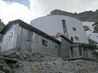
The Torino Hut is a high mountain refuge in the Alps in northwestern Italy. Located near the border with France, it is about 15 km (10 mi) southwest of Mont Dolent, the tripoint with Switzerland. The refuge is in the Mont Blanc massif above the town of Courmayeur in the Aosta Valley, Italy. It can be most easily accessed from the Italian side by the Skyway Monte Bianco cable car from La Palud in Courmayeur, with a change at the Pavilion du Mont Fréty. It can also be reached from Chamonix via the Aiguille du Midi, either by cable car which crosses the massif, or by a long crossing of the Glacier du Gèant. The refuge lies nearly directly above the 11.6 km (7.2 mi) Mont Blanc Tunnel, which passes deep underground, and connects Courmayeur to Chamonix.

The Grand Pilier d'Angle is a buttress on the southern side of Mont Blanc in the Mont Blanc massif in the Aosta Valley, Italy.
Pic Eccles is a mountain in the Mont Blanc massif in the Aosta Valley, Italy. It lies at the foot of the Innominata ridge to the summit of Mont Blanc. The mountain is named after the English mountaineer and geologist James Eccles.

Notre-Dame de Guérison is a Christian sanctuary situated in Courmayeur, at the foot of Mont Chétif, along the Val Veny road that leads to the Seigne pass, also known as the "Cremonis Iugum", used by the Romans to reach Gaul. It is well-known both in Italy and abroad, not only because of the surrounding landscape, but because it is very easy to reach by car from May to November and above all, is situated very close to an internationally famous tourist resort.
The Gonella Hut, sometimes called in Italian Rifugio del Dôme or in French Refuge du Dôme, is a high elevation mountain hut in the Aosta Valley in the Mont Blanc massif area of the Alps. It lies at an elevation of 3071 metres, above Val Veny near Courmayeur in Italy. The refuge is located on the Italian normal route to Mont Blanc.

The France–Italy border is 515 km long. It runs from the Alps in the north, a region in which it passes over Mont Blanc, down to the Mediterranean coast in the south. Three national parks are located along the border: Vanoise National Park and Mercantour National Park on the French side and Gran Paradiso National Park on the Italian side.

Skyway Monte Bianco is a cable car in the Italian Alps, linking the town of Courmayeur with Pointe Helbronner on the southern side of the Mont Blanc massif. Taking over three years to construct, it opened in 2015 at a cost of 110 million euros, and is considered to be the world's most expensive cable car installation.

The Brenva Glacier is a valley glacier, located on the southern side of the Mont Blanc massif in the Alps. It is the second longest and eighth largest glacier in Italy, and descends down into Val Veny, close to Entrèves, near Courmayeur. Over the centuries it has experienced a number of major rock avalanches which have shaped the glacier and influenced its movement.

The Planpincieux Glacier is a hanging glacier, located on the southern slopes of the Grandes Jorasses in the Mont Blanc massif of the Alps. It is located above the hamlet of Planpincieux, Val Ferret, in the Aosta Valley. The glacier has a length of 2 km (1.2 mi) and covers an area of 1.008 km2 (0.389 sq mi), and its elevation ranges from 2640 to 3680 m at a slope of 30°. Thermally, it is a temperate glacier.


