
Anantnag district is an administrative district of Indian-administered Jammu and Kashmir in the disputed Kashmir region. It is one of ten districts which make up the Kashmir Valley. The district headquarters is Anantnag city. As of 2011, it was the third most populous district of Jammu and Kashmir, after Jammu and Srinagar.

The Pulwama district is an administrative district of Indian-administered Jammu and Kashmir in the disputed Kashmir region. It is located to the south of Srinagar. Its district headquarters are situated in the city of Pulwama. It is located in the central part of the Kashmir Valley.

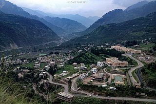
Awantipora or Avantipur or Aavantipur, known as Woontpor in Kashmiri, is a town, just opposite of Pulwama city, on the banks of the river Jhelum in the Pulwama district of Jammu and Kashmir, India.
Khrew is a town under municipal committee in Pulwama district in the Indian union territory of Jammu and Kashmir. It comes under Tehsil Pampore and District Pulwama of Union Territory of J&K. It is located at a distance of 20.3 km from Lal chowk city centre. It is famous for many things like a cement manufacturing hub where thousands of cement trucks are sent across the valley. It is also famous for the Indian army training camp where most of the new joinee soldiers get training and are sent to different places after the training is over. It is also famous for the education system having two higher secondary schools and many private schools. It is also famous for different religious places like Saint Sabir shah, Saint Syed shah Mantaqee, baba Qasim, and Jwala Mukhi Temple situated on the hilltop.
Tral is a town, sub-district and a notified area committee in the Pulwama district of Indian-administered Kashmir. The town is situated at a distance of 40 kilometres (25 mi) from summer capital, Srinagar and 26 kilometres (16 mi) from district headquarters, Pulwama. Tral is the second largest area committee in Pulwama district.

Budgam district is an administrative district of Indian-administered Jammu and Kashmir in Kashmir region. Created in 1979 with its headquarters at the town of Budgam, it is the district with the largest population of Shia Muslims in the Kashmir valley.
Ramban district is an administrative district in the Jammu division of Indian-administered Jammu and Kashmir in the disputed Kashmir region. It is located in a valley surrounded the Pir Panjal range. It was carved out as a separate district from erstwhile Doda district in 2007. It is located in the Jammu division. The district headquarters are at Ramban town, which is located midway between Jammu and Srinagar along the Chenab river in the Chenab valley on National Highway-44, approximately 151 km from Jammu and Srinagar.

Shopian district, known as Shupyan in Kashmiri, is an administrative district of Indian-administered Jammu and Kashmir in the disputed Kashmir region. It is a hill district with its administrative headquarters in Shopian town. As it is situated on the historical road commonly known as Mughal Road, most of its area is occupied by forests. Shopian district comes under the Pir Panjal Range which makes it very cold in winter. After partition of India, it was a tehsil of Pulwama district. In March, 2007, the district status was granted by the Government of India. The economy of the district depends on agriculture, particularly apple growing.

Kulgam district is an administrative district of Indian-administered Jammu and Kashmir in the disputed Kashmir region. It is in the Kashmir division and is located at a distance of 18 kilometres (11 mi) towards south-west of Anantnag. The district comprises block, tehsil and town of Kulgam.
Lariyar is a small village in Tral area of Pulwama district in Jammu and Kashmir, India. The population was 1,167 at the 2011 Indian census.
Wakura is a village located in the Ganderbal district of Jammu and Kashmir, India. In 2013 it was given tehsil status, with the tehsil headquarters located in Lar, 13 km away.
Lethapora, also known as Lethpora and Lalitpur, is a village in the Pampore tehsil of the Pulwama district of Jammu and Kashmir, India. It has a long history as it was named after a king Lalitaditya Muktapida, who was a powerful ruler of the Karkota dynasty of Kashmir. It was first named as Lalitpur and later changed to Lethapora. It is one of the main market for tourists and locals for Kashmiri dry fruits like walnuts, almonds etc. You can get world's finest saffron from here, which is available easily in the market. It mainly has three main markets that is Upper Market, Main Market and Down Market. Upper market is like the corporate area of the village which mainly has mixture of shops like saffron and other dry fruit shops, restaurants, hotels, tea stalls, banks, school, gym, showrooms etc. In Main Market, you will find basic shops selling fruits, vegetables, kirana and other basics and in the Down Market it mostly has saffron shops along with other shops, and restaurants

Thathri is a town and a notified area committee in Doda district in the Indian union territory of Jammu and Kashmir. Thathri valley is located in the foothills of the Himalayan mountains, about 85 km from Batote. Apart from having ample forests, the town contains many small streams flowing through its various parts. It is located on the banks of the Chenab River and the town area is spread over 1.50 sq. Km².

Padgampora, also known as Padgampur, is a village in Awantipora tehsil in Pulwama district of Indian administered Jammu and Kashmir. It is located 14 km (8.7 mi) towards East from District headquarters Pulwama. 14 km (8.7 mi) from Tral. 25 km from State capital Srinagar.
Rajpora, also known as Rajpur, is a Village and a Tehsil in the Pulwama district of the Kashmir Valley of Jammu and Kashmir, India. It is located 43 km (27 mi) away from Srinagar and 299 km (186 mi) away from Jammu. Rajpora is situated at 1,800 metres (5,900 ft) above the mean sea level.
Litter is a notified area and a town in Pulwama district of Jammu and Kashmir, India. It is located 13 km (8.1 mi) towards east from District headquarters Pulwama and 40 km (25 mi) from the summer capital of Srinagar. It is situated on the banks of Rambi Ara, which line Litter Pulwama with Aglar.

Indian Army operations in Jammu and Kashmir include security operations such as Operation Rakshak, which began in 1990, Operation Sarp Vinash in 2003 and Operation Randori Behak in 2020. Other operations include humanitarian missions such as Operation Megh Rahat and operations with a social aim such as Operation Goodwill and Operation Calm Down. The Indian Army works in tandem with the other arms of the Indian Armed Forces and security forces in Jammu and Kashmir such as during Mission Sahayata or joint operations.
Baragam, also known as Baragram, is a village in the Tral block of Pulwama district in the Indian union territory of Jammu and Kashmir. It is a small village located at 33°53′28.2″N75°03′26.9″E. It lies almost 35 km (22 mi) from Srinagar, and 17 km (11 mi) from district headquarters, Pulwama.
Gufkral is a site inhabited by potters who utilize the caves. Caves and archeological site are located at Banmir village in the Tral Tehsil of the Pulwama District, in the Kashmir Valley of Jammu and Kashmir, India. The cave of Gufkral is one of the oldest cave in Kashmir and some estimates trace their origin 2000-3000 BCE.

Midoora( مِیںڈورہ) also known as Midru, is a piedmont, agglomerated rural settlement in the Awantipora Tehsil of Pulwama district in Indian-administered Jammu and Kashmir. It is at a distance of 30 km from Srinagar and 8 km from the main town Tral and 7 km from Awantipora. In Northwest of it stands the majestic Wasturwan, a picturesque mountain forest.

