
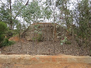
Woodanilling is a small town and locality in the Shire of Woodanilling, Great Southern region of Western Australia.
Crossman is a locality in the Shire of Boddington in the Peel Region of Western Australia, 125 kilometres (78 mi) south-southeast of the state capital, Perth, along Albany Highway, and 12 kilometres (7.5 mi) east of Boddington.

The Shire of Wandering is a local government area in the Wheatbelt region of Western Australia, and, with a population of 444 as at the 2016 census, is one of the nation's smallest. It covers an area of 1,901 square kilometres (734 sq mi) generally to the east of Albany Highway about 120 kilometres (75 mi) south-east of Perth, the state capital. The Shire's seat of government is the town of Wandering.

The Shire of Boddington is a local government area in the Peel region of Western Australia, about 120 kilometres (75 mi) south-east of the state capital, Perth. The Shire covers an area of 1,901 square kilometres (734 sq mi), and its seat of government is the town of Boddington.

The Shire of Collie is a local government area in the South West region of Western Australia, about 60 kilometres (37 mi) east of Bunbury and about 200 kilometres (124 mi) south of the state capital, Perth. The Shire covers an area of 1,711 square kilometres (661 sq mi), and its seat of government is the town of Collie.

The Shire of Woodanilling is a local government area in the Great Southern region of Western Australia, about 30 kilometres (19 mi) south of Wagin and about 260 kilometres (162 mi) south-southeast of the state capital, Perth. The Shire covers an area of 1,129 square kilometres (436 sq mi), and its seat of government is the town of Woodanilling.
Boscabel is a town and locality in the Shire of Kojonup, Great Southern region of Western Australia, located north of Kojonup. The Albany Highway passes through the locality, but not the townsite, from north to south.
Dingup is a rural locality of the Shire of Manjimup in the South West region of Western Australia. The Muir Highway forms the western and southern border of the locality.
Lower Hotham is a rural locality located in the Shire of Boddington in the Peel Region of Western Australia. The Hotham River flows though the locality, joining the Williams River in the southern parts of Lower Hotham.
Upper Murray is a rural locality located in the Shire of Boddington in the Peel Region of Western Australia. The Murray River traverses the locality from its eastern to its western border.
Wuraming is a rural locality located in the Shire of Boddington in the Peel Region of Western Australia. The locality is almost completely forested except for a section in the north-east where parts of the Boddington Gold Mine operation are located.

Buckingham is a rural locality of the Shire of Collie in the South West region of Western Australia. At the south-western edge of the locality, south of the Coalfields Highway, it borders the large coal mines of the Collie area while the remainder of the locality is predominantly forested.

Cardiff is a rural town in the Shire of Collie in the South West region of Western Australia.
Collie Burn is a rural town in the Shire of Collie in the South West region of Western Australia.
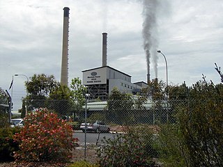
Muja is a rural town and locality of the Shire of Collie in the South West region of Western Australia. The western part of the locality is dominated by coal mining and the coal-fired Muja Power Station while the eastern part is rural and forested.
Mungalup is a rural town and locality of the Shire of Collie in the South West region of Western Australia.
Borderdale is a rural locality of the Shire of Broomehill–Tambellup in the Great Southern region of Western Australia. The Albany Highway forms the south-western border of the locality. The eastern part of the gazetted townsite of Tunney is located in Borderdale, while the western part is located in Cranbrook, with the Albany Highway forming the border.
Dartnall is a rural locality of the Shire of Broomehill–Tambellup in the Great Southern region of Western Australia. The Great Southern Highway and the Great Southern Railway form the far western border of the locality.
Kenmare is a rural locality of the Shire of Woodanilling in the Great Southern region of Western Australia. The Beaufort River forms much of the western border of the locality, which reaches as far west as Albany Highway in two places. The Martinup, Murapin, Miripin and Wardering Lake Nature Reserves are all located in the north of Kenmare, while the Wingedine Nature Reserve is located in the south.

Westwood is a rural locality of the Shire of Woodanilling in the Great Southern region of Western Australia. The eastern border of the locality is formed by the Great Southern Highway. The Strathmore Hill Nature Reserve is located within Westwood.
