Big Flat, Arkansas

Last updated

Big Flat, Arkansas
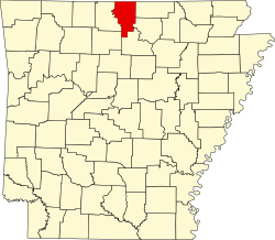
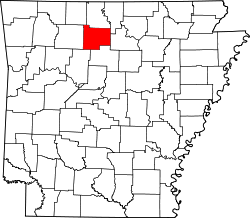
Baxter County and Searcy County Arkansas Incorporated and Unincorporated areas Big Flat Highlighted 0505980.svg
Location of Big Flat in Baxter and Searcy Counties, Arkansas.
Coordinates: 36°0′10″N92°24′24″W / 36.00278°N 92.40667°W / 36.00278; -92.40667
Country United States
State Arkansas
Counties Baxter, Searcy
Area
[1]
  Total1.07 sq mi (2.78 km2)
  Land1.07 sq mi (2.76 km2)
  Water0.01 sq mi (0.02 km2)
Elevation
[2]
1,253 ft (382 m)
Population
 (2020)
  Total88
  Density82.47/sq mi (31.85/km2)
Time zone UTC-6 (Central (CST))
  Summer (DST) UTC-5 (CDT)
ZIP code
72617
Area code 870
FIPS code 05-05980
GNIS feature ID2405261 [2]

Big Flat is a town in Baxter and Searcy counties in the U.S. state of Arkansas. The population was 88 at the 2020 census.

Contents

Geography

According to the United States Census Bureau, the town has a total area of 2.8 km2 (1.1 sq mi), of which 2.8 km2 (1.1 sq mi) is land and 0.93% is water.

List of highways

School district

The Baxter County portion of Big Flat is served by the Mountain View School District. [3] The small section in Searcy County is in the Searcy County School District. [4]

It was served by the Big Flat School District until July 1, 1985, when it merged with the Fifty Six School District into the Tri-County School District. On July 1, 1993, the Tri-County district was dissolved, with portions going to various districts, including the Mountain View district and the Marshall School District. Marshall consolidated into the Searcy County district on July 1, 2004. [5]

Demographics

Historical population
CensusPop.Note
1940 210
1950 197−6.2%
1960 21710.2%
1970 189−12.9%
1980 150−20.6%
1990 93−38.0%
2000 10411.8%
2010 1051.0%
2020 88−16.2%
U.S. Decennial Census [6]
2014 Estimate [7]

As of the census [8] of 2000, there were 104 people, 49 households, and 24 families residing in the town. The population density was37.2 people /km2 (96 people/sq mi). There were 68 housing units at an average density of 24.3 units /km2 (63 units/sq mi). The racial makeup of the town was 100.00% White.

There were 49 households, out of which 20.4% had children under the age of 18 living with them, 36.7% were married couples living together, 8.2% had a female householder with no husband present, and 49.0% were non-families. 44.9% of all households were made up of individuals, and 28.6% had someone living alone who was 65 years of age or older. The average household size was 2.12 and the average family size was 3.08.

In the town, the population was spread out, with 22.1% under the age of 18, 7.7% from 18 to 24, 23.1% from 25 to 44, 24.0% from 45 to 64, and 23.1% who were 65 years of age or older. The median age was 40 years. For every 100 females, there were 116.7 males. For every 100 females age 18 and over, there were 113.2 males.

The median income for a household in the town was $21,094, and the median income for a family was $24,375. Males had a median income of $18,750 versus $61,250 for females. The per capita income for the town was $11,294. There were no families and 11.3% of the population living below the poverty line, including no under eighteens and 34.8% of those over 64.

Notable people

Related Research Articles

<span class="mw-page-title-main">Searcy County, Arkansas</span> County in Arkansas, United States

Searcy County is a county located in the U.S. state of Arkansas. As of the 2020 census, the population was 7,828. The county seat is Marshall. The county was formed December 13, 1838, from a portion of Marion County and named for Richard Searcy, the first clerk and judge in the Arkansas Territory. The city of Searcy, Arkansas, some 70 miles away, shares the name despite having never been part of Searcy County. The county is an alcohol prohibition or dry county.

<span class="mw-page-title-main">Fulton County, Arkansas</span> County in Arkansas, United States

Fulton County is a county located in the U.S. state of Arkansas. As of the 2020 census, the population was 12,075. The county seat is Salem. Fulton County was formed on December 21, 1842, and named for William Fulton, the last governor of the Arkansas Territory. It is an alcohol prohibition or dry county.

<span class="mw-page-title-main">Boone County, Arkansas</span> County in Arkansas, United States

Boone County is a county located in the U.S. state of Arkansas, along the Missouri border. As of the 2020 census, the population was 37,373. The county seat is Harrison. It is Arkansas's 62nd county, formed on April 9, 1869.

<span class="mw-page-title-main">Baxter County, Arkansas</span> County in Arkansas, United States

Baxter County is a county in the Ozark Mountains of Arkansas. Created as Arkansas's 66th county on March 24, 1873, the county has eight incorporated municipalities, including Mountain Home, its largest city and county seat. The county is named for Elisha Baxter, the tenth governor of Arkansas. It is coterminal with the Mountain Home Micropolitan Statistical Area.

<span class="mw-page-title-main">Briarcliff, Arkansas</span> City in Arkansas, United States

Briarcliff is a second-class city in Baxter County, Arkansas, United States. The population was 236 at the 2010 census.

<span class="mw-page-title-main">Lakeview, Arkansas</span> Place in Arkansas, United States

Lakeview is a city in Baxter County, Arkansas, United States. The population was 741 at the 2010 census.

<span class="mw-page-title-main">Norfork, Arkansas</span> City in Arkansas, United States

Norfork is a city in Baxter County, Arkansas, United States. The population was 550 at the 2010 census.

<span class="mw-page-title-main">Salesville, Arkansas</span> City in Arkansas, United States

Salesville is a city in Baxter County, Arkansas, United States. The population was 450 in 2010.

<span class="mw-page-title-main">Highfill, Arkansas</span> Town in Arkansas, United States

Highfill is a town in Benton County, Arkansas, United States. The population was 1,587 as of the 2020 census. It is home to the Northwest Arkansas National Airport, which serves all of the Northwest Arkansas region. In September 2023, officials of the airport voted to detach itself from the city over taxing and public service disputes.

<span class="mw-page-title-main">Campbell Station, Arkansas</span> City in Arkansas, United States

Campbell Station is a city in Jackson County, Arkansas, United States. The population was 255 at the 2010 census.

<span class="mw-page-title-main">Allport, Arkansas</span> Town in Arkansas, United States

Allport is a town in Lonoke County, Arkansas, United States. Although a black enclave in the largely-white Lonoke County since the 1870s, the town did not incorporate until 1967 in order to receive funding for municipal services. Located within Central Arkansas along Highway 165, the community's economy is strongly tied to agriculture. The population was 115 at the 2010 Census.

<span class="mw-page-title-main">Fourche, Arkansas</span> Town in Arkansas, United States

Fourche is a town in Perry County, Arkansas, United States. The population was 59 at the 2000 census. It is part of the Little Rock–North Little Rock–Conway Metropolitan Statistical Area.

<span class="mw-page-title-main">Hatfield, Arkansas</span> Town in Arkansas, United States

Hatfield is a town in western Polk County, Arkansas, United States. The population was 413 at the 2010 census.

<span class="mw-page-title-main">DeValls Bluff, Arkansas</span> City in Arkansas, United States

DeValls Bluff is a city in and the county seat of the southern district of Prairie County, Arkansas, United States. The population was 619 at the 2010 census.

<span class="mw-page-title-main">Gilbert, Arkansas</span> Town in Arkansas, United States

Gilbert is a town in Searcy County, Arkansas, United States. The population was 26 at the 2020 census, ranking it as the smallest municipality in the state and one of the smallest in the nation. Over the years, Gilbert has gained a reputation as one of the coldest locations in Arkansas.

<span class="mw-page-title-main">Leslie, Arkansas</span> City in Arkansas, United States

Leslie is a city in Searcy County, Arkansas, United States. Located within the Boston Mountains, the most rugged subset of The Ozarks, the city was founded as a railroad and lumber town. Renamed from the original Wiley's Cove in 1887, the city saw prosperity relating to these industries through the 1920s. Today, this history is available to residents and visitors in the form of several properties listed on the National Register of Historic Places throughout the city. The population was 441 at the 2010 census.

<span class="mw-page-title-main">Pindall, Arkansas</span> Town in Arkansas, United States

Pindall is a town in Searcy County, Arkansas, United States. The population was 112 at the 2010 census. The town is said to be named for Governor Xenophon Overton Pindall.

<span class="mw-page-title-main">Bonanza, Arkansas</span> City in Arkansas, United States

Bonanza is a city in Sebastian County, Arkansas, United States. It is part of the Fort Smith, Arkansas-Oklahoma Metropolitan Statistical Area. At the 2010 Census, the population of Bonanza was 575. According to the 2018 US Census Bureau estimates, the population of Bonanza was 564. Bonanza began as a coal mining town of the Central Coal and Coke company.

<span class="mw-page-title-main">Central City, Arkansas</span> City in Arkansas, United States

Central City is a city in Sebastian County, Arkansas, United States. It is part of the Fort Smith, Arkansas-Oklahoma Metropolitan Statistical Area. At the 2010 Census, the population of Central City was 502. According to the 2018 US Census Bureau estimates, Central City had a population of 497.

<span class="mw-page-title-main">Higginson, Arkansas</span> City in Arkansas, United States

Higginson is a second-class city in White County, Arkansas, United States. Randall Homsley is the current mayor and was a volunteer police officer until the volunteer police force was disbanded.

References

  1. "2020 U.S. Gazetteer Files". United States Census Bureau. Retrieved October 29, 2021.
  2. 1 2 U.S. Geological Survey Geographic Names Information System: Big Flat, Arkansas
  3. School District Reference Map (2010 Census) Baxter County, AR (PDF) (Map). US Census Bureau. Retrieved July 12, 2011.
  4. "SCHOOL DISTRICT REFERENCE MAP (2010 CENSUS): Searcy County, AR." U.S. Census Bureau. Retrieved on June 16, 2018.
  5. "ConsolidationAnnex_from_1983.xls." Arkansas Department of Education. Retrieved on October 13, 2017.
  6. "Census of Population and Housing". Census.gov. Retrieved June 4, 2015.
  7. "Annual Estimates of the Resident Population for Incorporated Places: April 1, 2010 to July 1, 2014". Archived from the original on May 22, 2015. Retrieved June 4, 2015.
  8. "U.S. Census website". United States Census Bureau . Retrieved January 31, 2008.