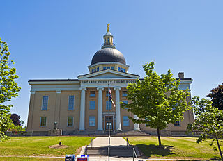
Ontario County is a county in the U.S. State of New York. As of the 2020 census, the population was 112,458. The county seat is Canandaigua. The county is part of the Finger Lakes region of the state.

Steuben County is a county located in the U.S. state of New York. As of the 2020 census, the population was 93,584. Its county seat is Bath. Its name is in honor of Baron von Steuben, a Prussian general who fought on the American side in the American Revolutionary War, though it is not pronounced the same. The county is part of the Southern Tier region of the state.

Friedrich Wilhelm August Heinrich Ferdinand von Steuben, also referred to as Baron von Steuben, was a German-born American army officer who played a leading role in the American Revolutionary War by reforming the Continental Army into a disciplined and professional fighting force. His contributions marked a significant improvement in the performance of U.S. troops.

Steuben is a town in Oneida County, New York, United States. The population was 1,110 at the 2010 census. The town is named after Baron von Steuben, a Prussian general who fought on the American side in the American Revolutionary War.

Whitestown is a town in Oneida County, New York, United States. The population was 18,667 at the 2010 census. The name is derived from Judge Hugh White, an early settler. The town is immediately west of Utica and the New York State Thruway passes across the town.

Herkimer is a town in Herkimer County, New York, United States, southeast of Utica. It is named after Nicholas Herkimer. The population was 9,566 at the 2020 census, down from 10,175 in 2010.
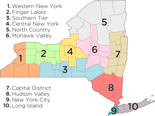
The Southern Tier is a geographic subregion of the broader Upstate region of New York State, geographically situated along or very near the state border with Pennsylvania. Definitions of the region vary widely, but generally encompass counties surrounding the Binghamton and Elmira-Corning metropolitan areas. This region is adjacent to the Northern Tier of Pennsylvania, and both these regions together are known as the Twin Tiers.
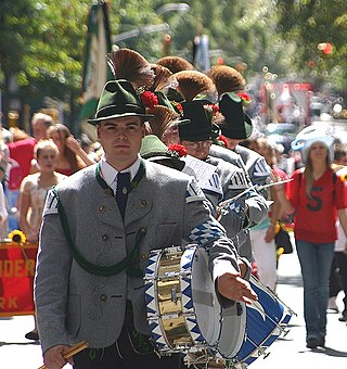
Von Steuben Day is a holiday traditionally held on a weekend in mid-September, celebrating the Prussian-born Baron Friedrich von Steuben, who arrived in the United States as a volunteer offering his services to General George Washington in the American Revolutionary War. Von Steuben is still regarded as one of the most important German Americans, as his training of the young American troops made victory against the British possible. Thus, his work helped gain independence for the United States of America. The day is generally considered the German-American event of the year, and many participants wear tracht costumes, including dirndls and lederhosen, to celebrate their heritage. Celebrations focus on parades where participants march, dance, and play music.
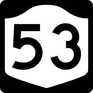
New York State Route 53 (NY 53) is a north–south state highway located in the Finger Lakes region of New York in the United States. It extends for 22.50 miles (36.21 km) from an intersection with NY 415 near the hamlet of Kanona in northern Steuben County to a junction with NY 21 in the village of Naples in southern Ontario County. Just north of Kanona, located within the town of Bath, NY 53 connects to the Southern Tier Expressway. About midway between Kanona and Naples, the route serves the hamlet of Prattsburgh.

Benjamin Walker was a Continental Army officer, businessman, and politician who served in the American Revolutionary War and later served as a United States Representative from New York.

Berlin Mountain is a 2,818-foot-tall (859 m) prominent peak in the Taconic Mountains of western New England and is located adjacent to Massachusetts's border with New York State. It is the highest point in Rensselaer County. The summit and west side of the mountain are located in New York; the east side lies within Williamstown, Massachusetts. The mountain is a bald, notable for its grassy summit and expansive views of the Hudson River Valley to the west. The 37-mile (60 km) Taconic Crest Trail traverses the mountain. Several other hiking trails approach the summit from the east. Much of the upper slopes and summit are within protected conservation land. Historically the lower slopes of the mountain were farmed heavily throughout the 19th Century. In addition to agriculture, there are several remnants of charcoal kilns located on the mountain that produced fuel for iron smelting.

Andrew J. Lorish was a Commissary Sergeant in the Union Army and a Medal of Honor recipient for his actions in the American Civil War.
Boody Hill is a summit located in Central New York Region of New York located in the Town of Steuben in Oneida County, northwest of Steuben.
Maple Mountain is a summit located in Central New York Region of New York located in the Town of Steuben in Oneida County, northwest of Steuben.
Oakes Hill is a summit located in Central New York Region of New York located in the Town of Steuben in Oneida County, north of Steuben.
Penn Mountain is a 1,808-foot-tall (551 m) mountain in the Tug Hill region of New York. It is located west of East Steuben in the town of Steuben in Oneida County. The mountain is the former site of an 80-foot-tall (24 m) steel fire lookout tower. The tower later ceased fire lookout operations and was removed in 1976.
Steuben Hill is a summit located in Central New York Region of New York located in the Town of Herkimer in Herkimer County, northwest of Herkimer.
Dairy Hill is a 1,844-foot-tall (562 m) summit located in Central New York Region of New York located in the Town of Norway in Herkimer County, southeast of Norway. The mountain is the former location of a 79-foot-6-inch-tall (24.23 m) steel fire lookout tower.
Gallis Hill is a 794-foot-tall (242 m) mountain in the Catskill Mountains region of New York. It is located northwest of Kingston in Ulster County. Jockey Hill is located north-northeast, and Morgan Hill is located west of Gallis Hill. In 1927, the Conservation Department built a steel fire lookout tower on the mountain. In 1950, the tower was closed and disassembled then moved to Overlook Mountain, where it still remains today.
Leonard Hill is a 2,592-foot-tall (790 m) mountain in Schoharie County, New York. It is located east-southeast of North Blenheim. Safford Hill is located northwest and Hubbard Hill is located southeast of Leonard Hill. In 1948, the Conservation Commission built an 80-foot-tall (24 m) steel fire lookout tower on the mountain. The tower ceased fire watching operations at the end of the 1988 season and was officially closed in early 1989. The tower remains on the summit, but is closed to the public. A local group is planning to restore the tower and reopen it to the public.

