Bridgnorth District

Last updated

Bridgnorth District
Shropshire Council offices in Westgate, Bridgnorth - geograph.org.uk - 4065792.jpg
Council Offices, Westgate, Bridgnorth
ShropshireBridgnorth.png
Shown within Shropshire non-metropolitan county
History
  OriginBridgnorth Rural District
Much Wenlock Municipal Borough
Shifnal Rural District (part)
  Created1 April 1974
  Abolished31 March 2009
  Succeeded by Shropshire
StatusDistrict
ONS code 39UB
GovernmentBridgnorth District Council
   HQ Bridgnorth

Bridgnorth District was a local government district in Shropshire, England, from 1974 to 2009. Its council was based in the town of Bridgnorth. The district also included the towns of Much Wenlock, Shifnal and Broseley and the villages of Albrighton and Sheriffhales, as well as RAF Cosford.

Contents

History

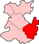
The district was formed on 1 April 1974, under the Local Government Act 1972. The district covered the former Bridgnorth Rural District, and nearly all of the Shifnal Rural District, excluding a small part of Shifnal parish within the area of Telford New Town, which went to Wrekin district. [1] The former municipal boroughs of Much Wenlock and Bridgnorth had been converted into rural boroughs in 1966 and 1967 respectively, making them part of Bridgnorth Rural District whilst retaining some of their civic dignities such as the right to appoint a mayor. [2]

The new district created in 1974 was administered by Bridgnorth District Council. The district and its council were abolished as part of the 2009 structural changes to local government in England. The council's functions were taken over from 1 April 2009 by Shropshire County Council, which was renamed Shropshire Council at the same time. [3]

Energy policy

In May 2006, a report commissioned by British Gas showed that housing in the district of Bridgnorth produced the 12th highest average carbon emissions in the country at 7,176 kg of carbon dioxide per dwelling.

Governance

Political control

The first elections to the council were held in 1973, initially operating as a shadow authority until the new arrangements came into effect on 1 April 1974. Political control of the council from 1974 until its abolition in 2009 was as follows: [4]

Party in controlYears
Independent 1974–2003
No overall control 2003–2009

Leadership

The last leader of the council was Elizabeth Yeomans, an independent.

CouncillorPartyFromTo
Elizabeth Yeomans [5] Independent 31 Mar 2009

Premises

The council was based at the Council Offices on Westgate in Bridgnorth. [6] It had been built in 1952 for the old Bridgnorth Rural District Council, one of the council's predecessors. [7] On the council's abolition in 2009, the building passed to Shropshire Council, which closed it in 2014. [8] The building was subsequently sold and demolished. [9]

Elections

Results maps

By-election results

Harrington By-Election 31 July 1997
PartyCandidateVotes%±%
Liberal Democrats 12651.9+5.0
Conservative 11748.2+48.2
Majority 93.7
Turnout 24321.4
Liberal Democrats gain from Independent Swing
Sheriffhales By-Election 20 June 2002
PartyCandidateVotes%±%
Conservative 17160.4+60.4
Independent 11239.6−16.6
Majority 5920.8
Turnout 28314.0
Conservative gain from Independent Swing
Ditton Priors By-Election 14 July 2005
PartyCandidateVotes%±%
Conservative 29562.5+11.9
Liberal Democrats 17737.5+37.5
Majority 11825.0
Turnout 47236.0
Conservative hold Swing

References

  1. "The English Non-metropolitan Districts (Definition) Order 1972", legislation.gov.uk , The National Archives, SI 1972/2039, retrieved 18 September 2022
  2. "Bridgnorth Rural District". A Vision of Britain through Time. GB Historical GIS / University of Portsmouth. Retrieved 18 September 2022.
  3. "The Shropshire (Structural Change) Order 2008", legislation.gov.uk , The National Archives, SI 2008/1866, retrieved 18 September 2022
  4. "Compositions Calculator". The Elections Centre. University of Exeter. Retrieved 21 May 2025. (Put "Bridgnorth" in search box to see specific results.)
  5. "Delight as relief road opens". Shropshire Star. 9 March 2009. Retrieved 18 September 2022.
  6. "No. 46624". The London Gazette . 4 July 1975. p. 8615.
  7. "Rural Council believe that half a loaf is better than no bread: New office block at Westgate is only a first instalment". Bridgnorth Journal. 11 April 1952. p. 7. Retrieved 8 July 2025.
  8. "For Sale: Former Council Offices at Westgate, Bridgnorth, WV16 5AA" (PDF). Shropshire Council. Retrieved 8 July 2025.
  9. Williams, Richard (6 November 2023). "Bridgnorth says farewell as former district council offices are demolished". Shropshire Star. Retrieved 8 July 2025.
  10. The District of Bridgnorth (Electoral Arrangements) Order 1976
  11. legislation.gov.uk - The Hereford and Worcester and Shropshire (County Boundaries) Order 1991. Retrieved on 5 November 2015.
  12. legislation.gov.uk - The District of Bridgnorth (Electoral Changes) Order 2000. Retrieved on 4 October 2015.

52°32′03″N2°25′06″W / 52.53417°N 2.41833°W / 52.53417; -2.41833