Bronson Avenue (Ottawa)

Last updated
View of Bronson Ave. looking north from Gilmour St. Bronsonave.JPG
View of Bronson Ave. looking north from Gilmour St.
View of Bronson Avenue from Somerset Street looking northward. Bronson Ave-facing downtown.jpg
View of Bronson Avenue from Somerset Street looking northward.
View of Bronson Avenue looking south from McLeod. Gladstoneave.JPG
View of Bronson Avenue looking south from McLeod.

Bronson Avenue ( Ottawa Road #79) is a major north-south arterial road in Ottawa, Ontario, Canada. It starts as a continuation of the Airport Parkway, which is an expressway to the Macdonald-Cartier International Airport. It continues past Carleton University, the Glebe, north through Centretown, and ends downtown at Sparks Street.

Ottawa Federal capital city in Ontario, Canada

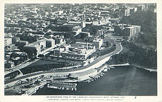
Ottawa is the capital city of Canada. It stands on the south bank of the Ottawa River in the eastern portion of southern Ontario. Ottawa borders Gatineau, Quebec; the two form the core of the Ottawa–Gatineau census metropolitan area (CMA) and the National Capital Region (NCR). As of 2016, Ottawa had a city population of 964,743 and a metropolitan population of 1,323,783 making it the fourth-largest city and the fifth-largest CMA in Canada.

Ontario Province of Canada

Ontario is one of the 13 provinces and territories of Canada and is located in east-central Canada. It is Canada's most populous province accounting for 38.3 percent of the country's population, and is the second-largest province in total area. Ontario is fourth-largest jurisdiction in total area when the territories of the Northwest Territories and Nunavut are included. It is home to the nation's capital city, Ottawa, and the nation's most populous city, Toronto, which is also Ontario's provincial capital.

Canada Country in North America

Canada is a country in the northern part of North America. Its ten provinces and three territories extend from the Atlantic to the Pacific and northward into the Arctic Ocean, covering 9.98 million square kilometres, making it the world's second-largest country by total area. Canada's southern border with the United States is the world's longest bi-national land border. Its capital is Ottawa, and its three largest metropolitan areas are Toronto, Montreal, and Vancouver. As a whole, Canada is sparsely populated, the majority of its land area being dominated by forest and tundra. Consequently, its population is highly urbanized, with over 80 percent of its inhabitants concentrated in large and medium-sized cities, many near the southern border. Canada's climate varies widely across its vast area, ranging from arctic weather in the north, to hot summers in the southern regions, with four distinct seasons.

Contents

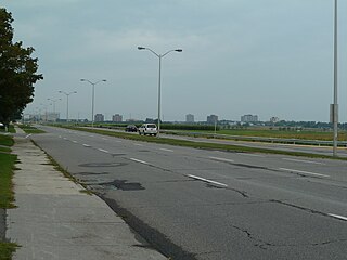
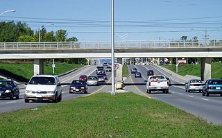
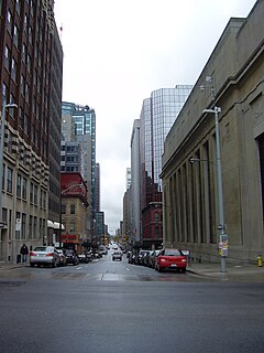
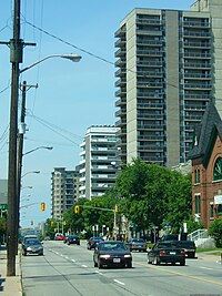
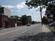
Starting as an expressway leading from the Airport Parkway, Bronson quickly becomes a six lane divided principal arterial with little or no direct frontage and a speed limit of 70 km/h (43 mph). From Colonel By Drive, Bronson Avenue continues as a four-lane undivided principal arterial road through residential and commercial areas with a speed limit of 50 km/h (31 mph). Upon reaching Albert Street, Bronson ends as a local road for downtown residents.

Limited-access road high-speed road with many characteristics of a controlled-access highway (freeway or motorway)

A limited-access road, known by various terms worldwide, including limited-access highway, dual-carriageway, expressway, and partial controlled access highway, is a highway or arterial road for high-speed traffic which has many or most characteristics of a controlled-access highway, including limited or no access to adjacent property, some degree of separation of opposing traffic flow, use of grade separated interchanges to some extent, prohibition of some modes of transport such as bicycles or horses, and very few or no intersecting cross-streets. The degree of isolation from local traffic allowed varies between countries and regions. The precise definition of these terms varies by jurisdiction.

Airport Parkway (Ottawa) in Ottawa, Ontario, Canada

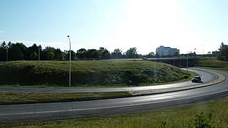
Airport Parkway is an expressway in Ottawa, Ontario, Canada. It runs from the Ottawa Macdonald-Cartier International Airport to an interchange with Heron Road where it turns into Bronson Avenue.

Colonel By Drive

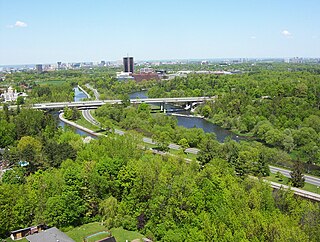
Colonel By Drive is an 8.1 km (5.0 mi) long scenic parkway in Ottawa, Ontario, Canada named after Colonel John By. It runs along the Rideau Canal from the end of Sussex Drive at Rideau Street. It then continues 8 km (5.0 mi) south and west to Hog's Back Road, winding through several residential areas and going past Dow's Lake and Carleton University. To the north, the road passes Department of National Defence Headquarters, the Ottawa Congress Centre and the Westin Hotel before ending at Wellington Street and Rideau Street. The rear door of the Government Conference Centre can be accessed from the street as well, after it passes under the Mackenzie King Bridge. It is named for Lieutenant-Colonel John By, who built the Rideau Canal. The winding two-lane road has a speed limit of 60 km/h (37 mph).

Bronson Avenue is a gateway to the southern neighborhoods of Ottawa and since it is generally faster to take Bronson Avenue than Bank Street, the street is usually quite busy, particularly at rush hour.

Bank Street (Ottawa) street in Ottawa, Ontario, Canada

Bank Street is the major north-south road in Ottawa, Ontario, Canada. It runs south from Wellington Street in downtown Ottawa, south through the neighbourhoods of Centretown, The Glebe, Old Ottawa South, Alta Vista, Hunt Club, and then through the villages of Blossom Park, Leitrim, South Gloucester, Greely, Metcalfe, Spring Hill, and Vernon before exiting the city limits at Belmeade Road.

Rush hour part of the day during which traffic congestion on roads and crowding on public transport is at its highest

A rush hour or peak hour is a part of the day during which traffic congestion on roads and crowding on public transport is at its highest. Normally, this happens twice every weekday; once in the morning and once in the afternoon or evening, the times during which the most people commute. The term is often used for a period of peak congestion that may last for more than one hour.

Glebe Collegiate Institute and Carleton University border on Bronson Avenue.

Glebe Collegiate Institute

Glebe Collegiate Institute (GCI) is a high school in the Glebe neighbourhood of Ottawa, Ontario, Canada. Administered by the Ottawa-Carleton District School Board (OCDSB), Glebe Collegiate Institute has approximately 1,700 students. Glebe CI is the district's largest school.

Carleton University university in Ottawa, Ontario, Canada

Carleton University is a public comprehensive university in Ottawa, Ontario, Canada. Founded in 1942 as Carleton College, a private, non-denominational evening college to serve veterans returning from World War II, the institution was chartered as a university by the provincial government in 1952 through the The Carleton University Act. The legislation was subsequently amended in 1957 to give the institution to its current name. The university moved to its current campus in 1959, and would expand rapidly throughout the 1960s amid broader efforts by the provincial government to increase support to post-secondary institutions and expand access to higher education.

There has been considerable debate about the nature of the road in the past few years; some have called for an expressway to be built in the corridor to link to a twinned Airport Parkway; but that has been extremely unpopular with local residents calling for improved public transit and is unlikely to be built.

Bronson Avenue took its name from Ottawa businessman and politician (Ontario MLA) Erskine Henry Bronson. [1]

Erskine Henry Bronson Canadian politician

Erskine Henry Bronson was an American-born Canadian businessman and political figure. He represented the riding of Ottawa in the Legislative Assembly of Ontario from 1886 to 1898.

Neighbourhoods

Bronson Avenue is considered a boundary line for several Ottawa neighbourhoods:

Major intersections

Major intersections (from south to north):

Points of interest

Route map: Google

KML file (edithelp)
KML is from Wikidata

Notes

  1. Brault, Lucien (1946), Ottawa Old and New, Ottawa historical information Institute, p. 311, OCLC   2947504


Related Research Articles

Hunt Club Road

Hunt Club Road, also known as Ottawa Road 32, is a major east-west route in Ottawa, Ontario, Canada. It originally ran from a dead end east of Bank Street to the Hunt Club Golf Course; later, there were many extensions due to the 1970s housing boom, first westward to Riverside Drive, then eastward to Hawthorne Road in the late 1980s. The section between Bank Street and Riverside Drive, originally only one lane in each direction, was expanded to two lanes in each direction in 1993-1994. It was further extended across the Rideau River and the southern edge of the suburbs to Richmond Road by the late 1990s; this extension is signed as West Hunt Club Road by the City of Ottawa. Construction to extend Hunt Club eastward to Highway 417 near Ramsayville was completed on August 21, 2014.

Riverside Drive (Ottawa)

Riverside Drive is a major road in Ottawa, Ontario, Canada that follows along the eastern bank of the Rideau River. Its northern terminus is at the Transitway/Via Rail underpass just south of the Queensway, and the road proceeds south to Limebank Road where it continues as River Road until the city limits. North of the Queensway, Riverside continues as Vanier Parkway, which travels through Vanier until Beechwood Avenue.

Brookfield Road

Brookfield Road is a short connecting street in Ottawa, Ontario, Canada. It runs from Riverside Drive past Brookfield High School to the Airport Parkway, and then in a separate segment as a local road in a residential area for some distance toward Bank Street.

Heron Road (Ottawa)

Heron Road is a major road in Ottawa, Ontario, Canada. It runs from Walkley Road at an angle to the Rideau River, where it turns into Baseline Road. Heron is home to the Public Works and Government Services Canada headquarters, the Sir Leonard Tilley Building, the Canada Post headquarters, and the Edward Drake Building. It is also home to St. Patrick's Intermediate High School and Herongate Mall.

Sussex Drive street in Ottawa

Sussex Drive is a major street in Ottawa, Ontario, Canada, and one of the city's major ceremonial and institutional routes.

Wellington Street (Ottawa)

Wellington Street is a major street in Ottawa, Ottawa, Canada. The street is notable for being the main street of the Parliamentary Precinct of the Parliament of Canada. It is one of the first two streets laid out in Bytown in 1826. The street runs from Booth Street to the Rideau Canal where it connects with Rideau Street and delimits the northern border of the downtown core. It is named after the Duke of Wellington, in recognition of his role in the creation of the Rideau Canal, and therefore of Ottawa.

Baseline Road (Ottawa) road in Ottawa, Ontario, Canada

Baseline Road is a road in Ottawa, Ontario, Canada.

Carling Avenue

Carling Avenue is a major east–west arterial road in the west end of Ottawa, Ontario, Canada. It runs from March Road in Kanata to Bronson Avenue in the Glebe. The road is named for John Carling, founder of Carling Brewery and Conservative MP and Senator, Postmaster General and Minister of Agriculture.

Downtown Ottawa Neighbourhood in Ottawa, Ontario, Canada

Downtown Ottawa is the central area of Ottawa, Ontario, Canada. Like other downtowns it is the commercial and economic centre of the city. It is sometimes referred to as the Central Business District and contains Ottawa's financial district. It is bordered by the Ottawa River to the north, the Rideau Canal to the east, Gloucester Street to the south and Bronson Avenue to the west. This area and the residential neighbourhood to the south are also known locally as 'Centretown'. The total population of the area is 4,876.

Innes Road is one of the most important streets in the east end of the City of Ottawa, Ontario, Canada, running through the former cities of Gloucester and Cumberland. It is the main route serving Blackburn Hamlet and south Orleans, as well as several industrial and commercial areas in east Ottawa. This road has changed considerably over the years.

Woodroffe Avenue

Woodroffe Avenue is a major north-south arterial road in Ottawa, Ontario, Canada's west end. It runs south from the Sir John A. Macdonald Parkway through Baseline Road and Barrhaven to just short of Prince of Wales Drive near Manotick. The road runs through the heart of Nepean in Ottawa's west end. A satellite Via Rail station is also located at the intersection of Fallowfield Road.

Blair Road is a road in the eastern part of Ottawa, Ontario, Canada. It begins just south of the Rockcliffe Parkway, but does not connect to the parkway, except for a small bike-path connection to the Ottawa River Pathway - one of the city's main bike trails that runs along the Ottawa River.

Metcalfe Street (Ottawa) street in downtown Ottawa

Metcalfe Street is a downtown arterial road in Ottawa, Ontario, Canada. It is named for Charles Theophilus Metcalfe, a nineteenth-century Governor General of the Province of Canada. It is a north-south route, operating one way northbound, providing a key thoroughfare from Highway 417. In the late 19th century and the early 20th century, it was one of the most prestigious addresses in Ottawa being home address of Ottawa's mayor Thomas Birkett, Canada's lumber and railroad baron John Rudolphus Booth, inventor Thomas Willson a.k.a. Carbide Willson, and Sir Alexander Campbell, law partner of Sir John A. Macdonald.

OConnor Street street in Ottawa, Canada

O'Connor Street is a downtown arterial road in Ottawa, Ontario, Canada. It is a north-south route, operating one way southbound, providing a key thoroughfare parallel to Bank Street.

Parkdale Avenue (Ottawa)

Parkdale Avenue is an arterial road located west of downtown Ottawa, Ontario, Canada. It runs in a north-south direction between the Sir John A. Macdonald Parkway and Carling Avenue in the Hintonburg and Civic Hospital neighbourhoods. It is an extremely busy road providing access to Tunney's Pasture, the Parkdale Market, the Ottawa Civic Hospital, and the Central Experimental Farm. Furthermore, it has direct connections to other major east-west arteries such as Scott Street, Wellington Street West, Gladstone Avenue, and Highway 417.