
Bank Street is the major commercial north-south street in Ottawa, Ontario, Canada. It runs south from Wellington Street in downtown Ottawa, south through the neighbourhoods of Centretown, The Glebe, Old Ottawa South, Alta Vista, Hunt Club, and then through the villages of Blossom Park, Leitrim, South Gloucester, Greely, Metcalfe, Spring Hill, and Vernon before exiting the city limits at Belmeade Road.

Rideau Street is a major street in downtown Ottawa, Ontario, Canada and one of Ottawa's oldest and most famous streets running from Wellington Street in the west to Montreal Road in the east where it connects to the Vanier district. Rideau Street is home to the Château Laurier, the CF Rideau Centre and the Government Conference Centre. Along with Wellington Street and Sussex Drive it was among the first streets in Ottawa to be host to businesses; it was created with the founding of the early town. The Plaza Bridge by the Rideau Canal is at its westmost point and the Cummings Bridge is at its eastmost point.
Wellington Street is a major street in Ottawa, Ottawa, Canada. The street is notable for being the main street of the Parliamentary Precinct of the Parliament of Canada. It is one of the first two streets laid out in Bytown in 1826. The street runs from Vimy Place, just west of Booth Street, to the Rideau Canal where it connects with Rideau Street and delimits the northern border of the downtown core. It is named after the Duke of Wellington, in recognition of his role in the creation of the Rideau Canal, and therefore of Ottawa.
Kent Street is a major street in downtown Ottawa, Ontario, Canada. One block west of Bank Street, Kent is one way running north. It begins at the Queensway at the south and ends at Wellington Street. The street has fewer storefronts than Bank Street. South of downtown it is mainly small and medium-sized office buildings, with some restaurants and residences. The northern part of the street is home to several large office towers, mainly governmental. It was originally known as Hugh Street.

The Transitway is a bus rapid transit (BRT) network operated by OC Transpo in Ottawa, Ontario, Canada. It comprises a series of bus-only roadways and reserved lanes on city streets and highways. The dedicated busways ensure that buses and emergency vehicles on the Transitway rarely intersect directly with the regular traffic, and make it possible for them to continue at full speed even during rush hour. OC Transpo operates a network of rapid routes which use the Transitway to connect communities with the O-Train light rail system. Additional bus routes also use segments of the Transitway.

Somerset Street is a street in Ottawa, Ontario, Canada. It is divided into Somerset Street East and Somerset Street West by the Rideau Canal.

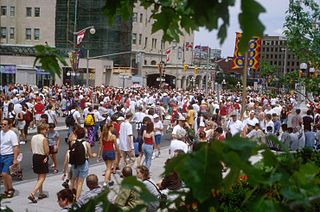
Downtown Ottawa is the central area of Ottawa, Ontario, Canada. Like other downtowns it is the commercial and economic centre of the city. It is sometimes referred to as the Central Business District and contains Ottawa's financial district. It is bordered by the Ottawa River to the north, the Rideau Canal to the east, Gloucester Street to the south and Bronson Avenue to the west. This area and the residential neighbourhood to the south are also known locally as 'Centretown'. The total population of the area is 4,876.

Lees Avenue is both a road and a neighbourhood in Ottawa, Ontario, Canada. The area lies in the narrow stretch between the Rideau Canal and Rideau River south of Sandy Hill and the Queensway and is part of Old Ottawa East. The neighbourhood is dominated by five large apartment buildings, some of the largest in Ottawa. These buildings range from low cost to moderate cost and mostly house new immigrants, students and young professionals. Across the Rideau River to the east Hurdman is a more recently built such area.

Hintonburg is a neighbourhood in Kitchissippi Ward in Ottawa, Ontario, Canada, located west of the Downtown core. It is a historically working-class, predominantly residential neighbourhood, with a commercial strip located along Wellington Street West. It is home to the Parkdale Farmer's Market, located along Parkdale Avenue, just north of Wellington.

Mackenzie King is a major station on the Ottawa Transitway. It is served by all three of OC Transpo's principal routes along with all express routes and several crosstown routes. It consists of reserved bus lanes on the Mackenzie King Bridge over the Rideau Canal, with indoor waiting areas attached to the adjacent Rideau Centre for westbound buses and the National Defence building for eastbound ones; the two sides are linked by crosswalks and pedestrian underpasses. It is one of the busiest stations, due to the high density, key connections and presence of numerous trip generators. There is also an OC Transpo shop in the Rideau Centre which supplies bus tickets, passes, and maps.

Elgin Street is a street in the Downtown core of Ottawa, Ontario, Canada. Originally named Biddy's Lane, it was later named after Lord Elgin.

The Sir John A. Macdonald Parkway, formerly the Ottawa River Parkway, is a four-lane scenic parkway along the Ottawa River in Ottawa, Ontario, Canada. It runs from Carling Avenue near Connaught Avenue, to Booth Street at the Canadian War Museum and National Holocaust Monument. It is maintained by the National Capital Commission. The speed limit is 60 km/h (37 mph). Bicycles are allowed on the road and on a parallel recreational path along the parkway.
Blair Road is a road in the eastern part of Ottawa, Ontario, Canada. It begins just south of the Rockcliffe Parkway, but does not connect to the parkway, except for a small bike-path connection to the Ottawa River Pathway - one of the city's main bike trails that runs along the Ottawa River.
Booth Street is a major street just to the west of downtown Ottawa, Ontario, Canada. North of Albert Street, Booth Street is designated as a city arterial road which proceeds to the Chaudière Bridge, connecting Ottawa to Gatineau. Once in Gatineau, it becomes Rue Eddy. This northernmost part of the street proceeds through the Lebreton Flats past the Canadian War Museum and the under construction National Holocaust Monument.
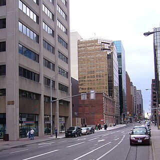
Slater Street is one of the main east-west roads in downtown Ottawa, Ontario, Canada. Slater is one way going east. It carries the eastbound portion of the Transitway through downtown, with Albert Street just to the north carrying the westbound portion. Previously, it was planned that O-Train would have been extended to downtown with its eastbound tracks running along Slater.
Tremblay Road is a major east-west road in Ottawa, Ontario, Canada. It runs parallel to Highway 417 to its south. The road begins at the Vanier Parkway, a continuation of the Highway 417 eastbound off-ramp to the Parkway. It runs a short distance past Belfast Road, crosses St. Laurent Boulevard and ends one block east at Triole Street. The road is largely residential with a few offices and light industry along the road, including offices for the Professional Institute of the Public Service of Canada. It is also home to Ottawa's Via Rail train Station, where one can catch a train to Kingston, Ontario, Toronto, Ontario or Montreal, Quebec.

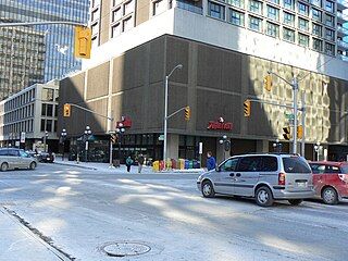
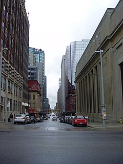
Metcalfe Street is a downtown arterial road in Ottawa, Ontario, Canada. It is named for Charles Theophilus Metcalfe, a nineteenth-century Governor General of the Province of Canada. It is a north-south route, operating one way northbound, providing a key thoroughfare from Highway 417. In the late 19th century and the early 20th century, it was one of the most prestigious addresses in Ottawa being home address of Ottawa's mayor Thomas Birkett, Canada's lumber and railroad baron John Rudolphus Booth, inventor Thomas Willson a.k.a. Carbide Willson, and Sir Alexander Campbell, law partner of Sir John A. Macdonald.
O'Connor Street is a downtown arterial road in Ottawa, Ontario, Canada. It is a north-south route, operating one way southbound, providing a key thoroughfare parallel to Bank Street.
17 Avenue SE is a major arterial road in east Calgary, Alberta. 17 Avenue SE is the focal point of the International Avenue Business Revitalization Zone (BRZ) and the main roadway through the former town of Forest Lawn. Chestermere Boulevard is a major arterial road and the eastern extension of 17 Avenue SE through Chestermere, Alberta, Canada. The roadway is a former alignment of Highway 1A.
