
New York State Route 2 (NY 2) is a state highway in the Capital District of New York in the United States. It extends for 30.89 miles (49.71 km) from an interchange with Interstate 87 (I-87) and NY 7 in the town of Colonie to the Massachusetts state line in Petersburgh, where it continues to Boston as Massachusetts Route 2. The route passes through the cities of Watervliet and Troy, where it connects to NY 32 and U.S. Route 4, respectively. In Grafton, located midway between Troy and Massachusetts, NY 2 serves Grafton Lakes State Park.
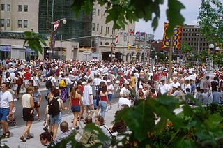
Wellington Street is a major street in Ottawa, Ottawa, Canada. The street is notable for being the main street of the Parliamentary Precinct of the Parliament of Canada. It is one of the first two streets laid out in Bytown in 1826. The street runs from Vimy Place, just west of Booth Street, to the Rideau Canal where it connects with Rideau Street and delimits the northern border of the downtown core. It is named after the Duke of Wellington, in recognition of his role in the creation of the Rideau Canal, and therefore of Ottawa.
Kent Street is a major street in downtown Ottawa, Ontario, Canada. One block west of Bank Street, Kent is one way running north. It begins at the Queensway at the south and ends at Wellington Street. The street has fewer storefronts than Bank Street. South of downtown it is mainly small and medium-sized office buildings, with some restaurants and residences. The northern part of the street is home to several large office towers, mainly governmental. It was originally known as Hugh Street.
Interstate 790 (I-790) is an auxiliary Interstate Highway in the city of Utica, New York, in the United States. It runs for 2.29 miles (3.69 km) from an interchange with New York State Route 5A (NY 5A) and NY 5S in downtown Utica to a pair of interchanges with Genesee Street east of the city. All of I-790 is concurrent with NY 5, and the portion south of NY 49 is also concurrent with NY 8 and NY 12. I-790 connects to exit 31 of the New York State Thruway (I-90) by way of an interchange near its east end. According to the New York State Department of Transportation (NYSDOT), I-790 follows NY 5 to Genesee Street while the highway leading to Thruway exit 31 is merely a pair of ramps connecting I-790 to its parent. The north–south portion of I-790 between its western terminus and NY 49 is named the North–South Arterial Highway.
Route 15 is a state highway in the U.S. states of Rhode Island and Massachusetts. The highway runs 8.3 miles (13.4 km) from U.S. Route 44 in North Providence, Rhode Island east through Pawtucket to the Massachusetts state line, where the highway continues for 0.23 miles (0.37 km) to Route 152 in Seekonk.

State Route 236 is a primary state highway in the U.S. state of Virginia. The state highway runs 15.63 miles (25.15 km) from U.S. Route 29 and US 50 in Fairfax east to SR 400 in Alexandria. SR 236 is a major suburban arterial highway that connects the independent cities of Fairfax and Alexandria via Annandale in Fairfax County. The state highway is known as Main Street in City of Fairfax, Little River Turnpike in Fairfax County, where the highway meets Interstate 495 (I-495), and Duke Street in Alexandria, where the road has junctions with I-395 and US 1.
New York State Route 27 (NY 27) is a 120.58-mile (194.05 km) long state highway that runs east-west from Interstate 278 (I-278) in the New York City borough of Brooklyn to Montauk Point State Park on Long Island, New York. Its two most prominent components are Sunrise Highway and Montauk Highway, the latter of which includes the Montauk Point State Parkway. NY 27 acts as the primary east-west highway on southern Long Island east of the interchange with the Heckscher State Parkway in Islip Terrace. The entire route in Suffolk, Nassau, and Queens counties were designated by the New York State Senate as the POW/MIA Memorial Highway. The highway gives access to every town on the South Shore. NY 27 is the easternmost state route in the state of New York.
The Lee Roy Selmon Expressway, originally known as the Southern Crosstown Expressway is a 14.168-mile (22.801 km) all-electronic, limited access toll road in Hillsborough County, Florida, It connects the South Tampa neighborhood near MacDill Air Force Base with Downtown Tampa and the bedroom community of Brandon. The expressway was built in stages, opening between 1976 and 1987.
U.S. Route 422 (US 422) is a 271-mile (436 km) long spur route of US 22 split into two segments in the U.S. states of Ohio and Pennsylvania. The western segment of US 422 begins in downtown Cleveland and ends at Ebensburg, Pennsylvania. The eastern segment, located entirely within Pennsylvania, begins in Hershey and ends at King of Prussia, PA, near Philadelphia. U.S. Route 422 Business is the offshoot road into each of 4 towns along the way.
Albert Street is one of the main east-west roads in downtown Ottawa, Ontario, Canada. Albert is one way going west. It carries the westbound portion of the transitway through downtown, with Slater Street just to the south carrying the eastbound portion. Previously, it was planned that O-Train would have been extended to downtown running westbound along Albert.
Booth Street is a major street just to the west of downtown Ottawa, Ontario, Canada. North of Albert Street, Booth Street is designated as a city arterial road which proceeds to the Chaudière Bridge, connecting Ottawa to Gatineau. Once in Gatineau, it becomes Rue Eddy. This northernmost part of the street proceeds through the Lebreton Flats past the Canadian War Museum and the under construction National Holocaust Monument.
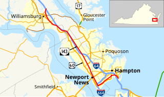
State Route 143 is a primary state highway in the U.S. state of Virginia. The state highway runs 35.39 miles (56.95 km) from Camp Peary near Williamsburg east to U.S. Route 258 at Fort Monroe in Hampton. SR 143 is a major local thoroughfare on the Virginia Peninsula portion of the Hampton Roads metropolitan area. The state highway is named Merrimac Trail through the independent city of Williamsburg and adjacent portions of York County and James City County. SR 143 follows Jefferson Avenue through the city of Newport News from the Williamsburg area past Virginia Peninsula Regional Jail to near Downtown Newport News. The state highway, which mostly runs northwest–southeast, heads northeast from Newport News, serving as one highway connecting the downtown areas of Newport News and Hampton. SR 143 parallels both US 60 and Interstate 64 (I-64) extensively, and sometimes very closely, throughout its course. The state highway also runs concurrently with US 60 in Hampton and with US 17 in Newport News.
Delaware Route 2 (DE 2) is a 10.81-mile-long (17.40 km) east–west highway located in northern New Castle County, Delaware. It runs from DE 72 and DE 273 on the eastern edge of Newark east to DE 52 in Wilmington. DE 2 is known variously as Capitol Trail, Kirkwood Highway, and Lincoln and Union streets along its route. Between Newark and Wilmington, the route is a four- to six-lane divided highway that passes through suburban areas. In Wilmington, DE 2 is routed along a one-way pair of city streets.

Pennsylvania Route 3 is a 24.3-mile (39.1 km) state highway located in the southeastern portion of Pennsylvania. The route connects U.S. Route 322 Business in West Chester with PA 611 in Philadelphia. The route begins in downtown West Chester and heads east out of town as a one-way pair of streets. Between West Chester and Upper Darby Township, PA 3 follows a four-lane divided highway known as West Chester Pike through suburban areas. Along this stretch, the route passes through Edgmont, Newtown Square, Broomall, and Havertown. The route has an interchange with Interstate 476 (I-476) between Broomall and Havertown. Upon reaching Upper Darby, PA 3 heads into Philadelphia along Market Street. In Philadelphia, the route follows multiple one-way pairs, running along Chestnut Street eastbound and Walnut Street westbound in West Philadelphia before heading into Center City Philadelphia along Market Street eastbound and John F. Kennedy Boulevard westbound and ending at Philadelphia City Hall.
Delaware Route 273 (DE 273) is a state highway in New Castle County, Delaware. The route runs from Maryland Route 273 (MD 273) at the Maryland border near Newark east to DE 9 and DE 141 in New Castle. The route runs through suburban areas between Newark and New Castle as a multilane road, passing through Ogletown and Christiana. DE 273 intersects DE 896 in downtown Newark; DE 2/DE 72 on the eastern edge of Newark; DE 4 in Ogletown; Interstate 95 (I-95), DE 7, and DE 1 in Christiana; DE 37 in Pleasantville; and DE 58 and U.S. Route 13 (US 13)/US 40 in Hares Corner.

Pennsylvania Route 462 is a 32-mile-long (51 km) east–west running local state route in York and Lancaster counties in central Pennsylvania. The western terminus is west of York, and the eastern terminus is east of Lancaster. At both ends, PA 462 terminates at U.S. Route 30, which follows a mostly freeway alignment parallel to the north between York and Lancaster. The route heads east into York, where it follows the one-way pair of Market Street eastbound and Philadelphia Street westbound. In York, PA 462 runs concurrent with PA 74 and crosses Interstate 83 Business. East of York, the route becomes a multilane road and has an interchange with I-83 and crosses PA 24. PA 462 continues east through Hallam to Wrightsville and passes through that town before it crosses the Susquehanna River and runs through Columbia. East of here, the route continues through Mountville before reaching the city of Lancaster. In Lancaster, PA 462 is routed on the one-way pair of King Street eastbound and West Walnut Street, with the westbound direction concurrent with PA 23. The route crosses US 222/PA 272 and northbound PA 72 in Lancaster. East of Lancaster, PA 462 becomes a multilane road again and continues to its eastern terminus.

Delaware Route 48 (DE 48) is a state highway in New Castle County, Delaware. The route runs from DE 41 in Hockessin east to U.S. Route 13 Business in downtown Wilmington. The route passes through suburban areas of Wilmington such as Lancaster Pike, intersecting DE 100 and DE 141. DE 48 continues into Wilmington as Lancaster Avenue and intersects DE 2, where it splits into the one-way pair of Lancaster Avenue eastbound and Second Street westbound. Upon reaching downtown Wilmington, the route intersects Interstate 95 (I-95)/US 202 and DE 4 before continuing to the eastern terminus.

Metcalfe Street is a downtown arterial road in Ottawa, Ontario, Canada. It is named for Charles Theophilus Metcalfe, a nineteenth-century Governor General of the Province of Canada. It is a north-south route, operating one way northbound, providing a key thoroughfare from Highway 417. In the late 19th century and the early 20th century, it was one of the most prestigious addresses in Ottawa being home address of Ottawa's mayor Thomas Birkett, Canada's lumber and railroad baron John Rudolphus Booth, inventor Thomas Willson a.k.a. Carbide Willson, and Sir Alexander Campbell, law partner of Sir John A. Macdonald.
O'Connor Street is a downtown arterial road in Ottawa, Ontario, Canada. It is a north-south route, operating one way southbound, providing a key thoroughfare parallel to Bank Street.

Stony Plain Road is an expressway and arterial road Edmonton, Alberta. Parkland Highway is an alternative route to the corresponding section of Highway 16 in Parkland County.
