
Bank Street is the major commercial north-south street in Ottawa, Ontario, Canada. It runs south from Wellington Street in downtown Ottawa, south through the neighbourhoods of Centretown, The Glebe, Old Ottawa South, Alta Vista, Hunt Club, and then through the villages of Blossom Park, Leitrim, South Gloucester, Greely, Metcalfe, Spring Hill, and Vernon before exiting the city limits at Belmeade Road.

Hunt Club Road, also known as Ottawa Road 32, is a major east–west route in Ottawa, Ontario, Canada. It originally ran from a dead end east of Bank Street to the Hunt Club Golf Course; later, there were many extensions due to the 1970s housing boom, first westward to Riverside Drive, then eastward to Hawthorne Road in the late 1980s. The section between Bank Street and Riverside Drive, originally only one lane in each direction, was expanded to two lanes in each direction in 1993–1994. It was further extended across the Rideau River and the southern edge of the suburbs to Richmond Road by the late 1990s; this extension is signed as West Hunt Club Road by the City of Ottawa. Construction to extend Hunt Club eastward to Highway 417 near Ramsayville was completed on August 21, 2014.

Riverside Drive is a major road in Ottawa, Ontario, Canada that follows along the eastern bank of the Rideau River. Its northern terminus is at the Transitway/Via Rail underpass just south of the Queensway, and the road proceeds south to Limebank Road where it continues as River Road until the city limits. North of the Queensway, Riverside continues as Vanier Parkway, which travels through Vanier until Beechwood Avenue.

Main Street is an arterial road in Ottawa, Ontario, Canada.

Highway 7, known for most of its length as the Lougheed Highway and Broadway, is an alternative route to Highway 1 through the Lower Mainland region of British Columbia. Whereas the controlled-access Highway 1 follows the southern bank of the Fraser River, Highway 7 follows the northern bank.

Laurier Avenue(French: Avenue Laurier) is a central east west street running through Ottawa, Ontario, Canada. Originally known as "Maria Street" and "Theodore Street", it was renamed in honour of Canadian Prime Minister Sir Wilfrid Laurier. Laurier House, the residence of Prime Ministers Laurier and William Lyon Mackenzie King, is located at the corner of Laurier Avenue East and Chapel Street.
Russell Road is a road in Eastern Ontario, Canada.
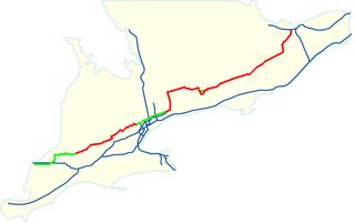
King's Highway 7, commonly referred to as Highway 7 and The 7 historically as the Northern Highway, is a provincially maintained highway in the Canadian province of Ontario. At its peak, Highway 7 measured 716 km (445 mi) in length, stretching from Highway 40 east of Sarnia in Southwestern Ontario to Highway 17 west of Ottawa in Eastern Ontario. However, due in part to the construction of Highways 402 and 407, the province transferred the sections of Highway 7 west of London and through the Greater Toronto Area to county and regional jurisdiction. The highway is now 535.7 km (332.9 mi) long; the western segment begins at Highway 4 north of London and extends 154.1 km (95.8 mi) to Georgetown, while the eastern segment begins at Donald Cousens Parkway in Markham and extends 381.6 km (237.1 mi) to Highway 417 in Ottawa.
Baseline Road is a road in Ottawa, Ontario, Canada.

Barrhaven is a rapidly growing suburban neighbourhood in the southwest of the urban area of the city of Ottawa, Ontario, Canada, about 17 km (11 mi) southwest of downtown Ottawa. Prior to amalgamation with Ottawa in 2001, Barrhaven was part of the City of Nepean. Its population as of the Canada 2016 Census was 87,234.
Illinois Route 23 is a north–south state highway in northern Illinois. It runs from Illinois Route 116 in Pontiac north to U.S. Route 14 south of Harvard. This is a distance of 122.77 miles (197.58 km).
Trim Road is an arterial road in the eastern end of Orléans, Ontario, a suburb of Ottawa. It serves as the only road access to Petrie Island and its public beach in the Ottawa River. From Petrie Island, Trim runs south through the eastern suburban areas of Orleans and then south into rural former Cumberland Township. It travels through the communities of Chartrand and Navan before ending at Perreault Road. It has a total length of 14.4 km (8.9 mi) and connects with Regional Road 174 that connects with Highway 417 further to the west. Its status as a numbered road in Ottawa's city road status ends at Innes Road on the south side of Orleans.
Fourth Line Road is a designated arterial road in the rural portion of Ottawa, Ontario, Canada. The street follows one of the meridian lines first laid out when Carleton County was surveyed. It begins southeast of Richmond, Ontario at Brophy Drive, and runs southeast until it hits the Rideau River, where it turns into Donnelly Drive at Reevcraig Road South. Fourth Line Road passes through the heart of North Gower, Ontario, and when in that town it is known as "Main Street." The road runs just to the west of Highway 416, which is the more important north-south route.The southern portion of it was originally part of Ontario Highway 16.
Albion Road is an important north–south road in the southern part of Ottawa, Ontario, Canada. The street begins in the north as Albion Road North, at Walkley Road.
Blair Road is a road in the eastern part of Ottawa, Ontario, Canada. It begins just south of the Rockcliffe Parkway, but does not connect to the parkway, except for a small bike-path connection to the Ottawa River Pathway - one of the city's main bike trails that runs along the Ottawa River.
King's Highway 148, commonly referred to as Highway 148, is a provincially maintained highway in Ontario, Canada. The highway acts as an extension of Route 148 in Quebec, once connecting it with Highway 17, the Trans-Canada Highway, near Pembroke. It was shortened to its present terminus in 1997, and now connects downtown Pembroke to the provincial border. Highway 148 follows a route that was once part of Highway 17 and Highway 62 until the Pembroke Bypass opened in 1982.
Route 159 is a 21.14-mile-long (34.02 km) state highway connecting the Hartford and Springfield areas in the U.S. states of Connecticut and Massachusetts. It begins as the northern extension of Main Street in Hartford and proceeds northward along the west bank of the Connecticut River towards Agawam, Massachusetts. The route ends at the junction of Route 147 and Route 75 in Agawam center just south of the West Springfield city line. The route was originally designated as U.S. Route 5A in 1932 and was renumbered to its modern designation in October 1968.
Strandherd Drive is a major road serving the community of Barrhaven in southwest Ottawa.

State Route 358 (SR 358) is a 0.92-mile-long (1.48 km) north–south state highway in the northern portion of the U.S. state of Ohio. The southern terminus of SR 358 is at a T-intersection with SR 163 nearly 5.75 miles (9.25 km) east of Oak Harbor, just north of the Portage River. Its northern terminus is at SR 2 at an intersection just outside Camp Perry about three and a half miles (5.6 km) west of Port Clinton.

Parkdale Avenue is an arterial road located west of downtown Ottawa, Ontario, Canada. It runs in a north-south direction between the Sir John A. Macdonald Parkway and Carling Avenue in the Hintonburg and Civic Hospital neighbourhoods. It is an extremely busy road providing access to Tunney's Pasture, the Parkdale Market, the Ottawa Civic Hospital, and the Central Experimental Farm. Furthermore, it has direct connections to other major east-west arteries such as Scott Street, Wellington Street West, Gladstone Avenue, and Highway 417.